Bangor Trident Base elevation
Bangor Trident Base (Washington, Kitsap County), United States elevation is 110 meters and Bangor Trident Base elevation in feet is 361 ft above sea level [src 1]. Bangor Trident Base is a populated place (feature code) with elevation that is 169 meters (554 ft) smaller than average city elevation in United States.
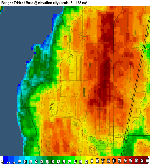
Below is the Elevation map of Bangor Trident Base, which displays elevation range with different colors. Scale of the first map is from -5 to 168 m (-16 to 551 ft) with average elevation of 106.3 meters (=349 ft) [note 1]
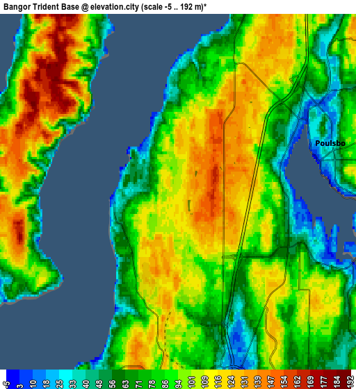
These maps also provides idea of topography and contour of this city, they are displayed at different zoom levels. More info about maps, scale and edge coordinates you can find below images.
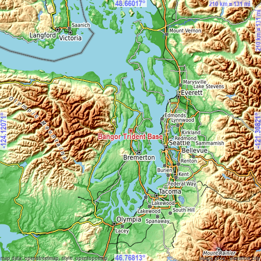
| \ | Map #1 | Map #2 | Topo.Map |
| Scale [m] | -5..168 m | -5..192 m | × |
| Scale [ft] | -16..551 ft | -16..630 ft | × |
| Average | 106.3 m = 349 ft | 91.5 m = 300 ft | × |
| Width | 6.57 km = 4.1 mi | 13.15 km = 8.2 mi | 210.4 km = 130.7 mi |
| Height | 6.57 km = 4.1 mi | 13.15 km = 8.2 mi | 210.4 km = 130.7 mi |
| ↑Max Latitude | 47.752294° | 47.781832° | 48.66017° |
| Latitude at center | 47.72274° | 47.72274° | 47.72274° |
| ↓Min Latitude | 47.693169° | 47.663581° | 46.76813° |
| ← Min Longitude | -122.758405° | -122.802351° | -124.12071° |
| Longitude center | -122.71446° | -122.71446° | -122.71446° |
| →Max Longitude | -122.670515° | -122.626569° | -121.30821° |
Nearby cities:
Cities around Bangor Trident Base sort by population:
• Bainbridge Island elevation 26 m
18 km,  126°
126°
• Silverdale 1 m
8.8 km,  170°
170°
• Poulsbo 7 m
5.3 km,  73°
73°
• Tracyton 30 m
13.4 km,  160°
160°
• Suquamish 21 m
12.2 km,  85°
85°
• Indianola 8 m
14.4 km,  79°
79°
• Erlands Point-Kitsap Lake 16 m
14 km,  176°
176°
• Lofall 27 m
10.8 km,  22°
22°
• Enetai 37 m
17.6 km,  150°
150°
• Chico 16 m
12.4 km, 178°
• Rocky Point 41 m
14.8 km, 166°
• Seabeck 28 m
12.6 km,  222°
222°
Multilingual:
 En español:
Bangor Trident Base elevación 110 m.
 En France:
Bangor Trident Base élévation 110 m.
 Auf Deutsch:
Bangor Trident Base höhe über dem Meeresspiegel ist 110 m.
 На русском:
Bangor Trident Base высота над уровнем моря 110 м
Sources and notes:
- [note 1] Map square and city borders are not equal. Map elevation data is calculated only from area inside that square.
- [src 1] Elevation data from geonames database provided with same terms of usage.
- [src 2] The elevation map of Bangor Trident Base is generated using elevation data from NASA's 3 arcsec (90m) resolution SRTM data.
- [src 3] Base (background) map © OpenStreetMap contributors tiles are generated by Geofabrik and OpenTopoMap.
Copyright & License:
This Bangor Trident Base Elevation Map is licensed under CC BY-SA. You may reuse any part from this page, if you give a proper credit by linking to this URL:
 More info on terms of use page.