Fort Stewart elevation
Fort Stewart (Georgia, Liberty County), United States elevation is 27 meters and Fort Stewart elevation in feet is 89 ft above sea level [src 1]. Fort Stewart is a populated place (feature code) with elevation that is 252 meters (827 ft) smaller than average city elevation in United States.
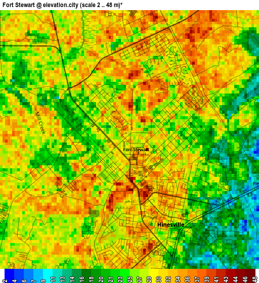
Below is the Elevation map of Fort Stewart, which displays elevation range with different colors. Scale of the first map is from 2 to 48 m (7 to 157 ft) with average elevation of 27.6 meters (=91 ft) [note 1]
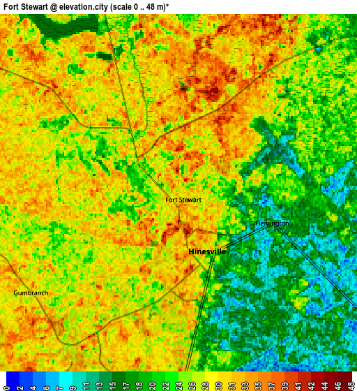
These maps also provides idea of topography and contour of this city, they are displayed at different zoom levels. More info about maps, scale and edge coordinates you can find below images.
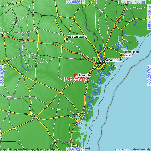
| \ | Map #1 | Map #2 | Topo.Map |
| Scale [m] | 2..48 m | 0..48 m | × |
| Scale [ft] | 7..157 ft | 0..157 ft | × |
| Average | 27.6 m = 91 ft | 25.6 m = 84 ft | × |
| Width | 8.3 km = 5.2 mi | 16.6 km = 10.3 mi | 265.6 km = 165 mi |
| Height | 8.3 km = 5.2 mi | 16.6 km = 10.3 mi | 265.6 km = 165 mi |
| ↑Max Latitude | 31.909482° | 31.946779° | 33.05861° |
| Latitude at center | 31.87217° | 31.87217° | 31.87217° |
| ↓Min Latitude | 31.834843° | 31.797501° | 30.67026° |
| ← Min Longitude | -81.653955° | -81.697901° | -83.01626° |
| Longitude center | -81.61001° | -81.61001° | -81.61001° |
| →Max Longitude | -81.566065° | -81.522119° | -80.20376° |
Nearby cities:
Cities around Fort Stewart sort by population:
• Hinesville elevation 24 m
3.1 km,  154°
154°
• Richmond Hill 6 m
29.9 km,  75°
75°
• Georgetown 7 m
38.2 km,  71°
71°
• Jesup 33 m
39.3 km,  221°
221°
• Glennville 57 m
30.9 km,  283°
283°
• Walthourville 33 m
11.1 km,  191°
191°
• Bloomingdale 12 m
41.2 km,  45°
45°
• Pembroke 34 m
29.4 km,  357°
357°
• Claxton 59 m
42.5 km,  319°
319°
• Ludowici 22 m
22.1 km,  214°
214°
• Midway 20 m
18.5 km,  113°
113°
• Henderson 1 m
36.4 km, 65°
Multilingual:
 En español:
Fort Stewart elevación 27 m.
 En France:
Fort Stewart élévation 27 m.
 Auf Deutsch:
Fort Stewart höhe über dem Meeresspiegel ist 27 m.

Sources and notes:
- [note 1] Map square and city borders are not equal. Map elevation data is calculated only from area inside that square.
- [src 1] Elevation data from geonames database provided with same terms of usage.
- [src 2] The elevation map of Fort Stewart is generated using elevation data from NASA's 3 arcsec (90m) resolution SRTM data.
- [src 3] Base (background) map © OpenStreetMap contributors tiles are generated by Geofabrik and OpenTopoMap.
Copyright & License:
This Fort Stewart Elevation Map is licensed under CC BY-SA. You may reuse any part from this page, if you give a proper credit by linking to this URL:
 More info on terms of use page.