McGuire AFB elevation
McGuire AFB (New Jersey, Burlington County), United States elevation is 35 meters and McGuire AFB elevation in feet is 115 ft above sea level [src 1]. McGuire AFB is a populated place (feature code) with elevation that is 244 meters (801 ft) smaller than average city elevation in United States.
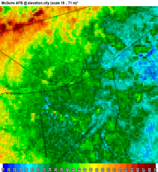
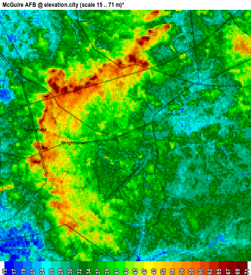
Below is the Elevation map of McGuire AFB, which displays elevation range with different colors. Scale of the first map is from 18 to 71 m (59 to 233 ft) with average elevation of 39 meters (=128 ft) [note 1]
These maps also provides idea of topography and contour of this city, they are displayed at different zoom levels. More info about maps, scale and edge coordinates you can find below images.
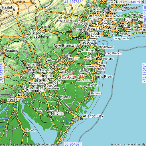
| \ | Map #1 | Map #2 | Topo.Map |
| Scale [m] | 18..71 m | 15..71 m | × |
| Scale [ft] | 59..233 ft | 49..233 ft | × |
| Average | 39 m = 128 ft | 36.6 m = 120 ft | × |
| Width | 7.48 km = 4.6 mi | 14.96 km = 9.3 mi | 239.4 km = 148.8 mi |
| Height | 7.48 km = 4.6 mi | 14.96 km = 9.3 mi | 239.4 km = 148.8 mi |
| ↑Max Latitude | 40.073406° | 40.107026° | 41.10788° |
| Latitude at center | 40.03977° | 40.03977° | 40.03977° |
| ↓Min Latitude | 40.006117° | 39.972448° | 38.95467° |
| ← Min Longitude | -74.625685° | -74.669631° | -75.98799° |
| Longitude center | -74.58174° | -74.58174° | -74.58174° |
| →Max Longitude | -74.537795° | -74.493849° | -73.17549° |
Nearby cities:
Cities around McGuire AFB sort by population:
• Browns Mills elevation 28 m
7.5 km,  180°
180°
• Fort Dix 48 m
3.3 km,  250°
250°
• Magnolia 23 m
12.1 km,  213°
213°
• Country Lake Estates 28 m
11.3 km,  163°
163°
• Bordentown 22 m
16.2 km,  316°
316°
• Shrewsbury 43 m
16.5 km,  15°
15°
• Groveville 21 m
16.4 km,  332°
332°
• New Egypt 26 m
5.3 km,  54°
54°
• Pemberton Heights 22 m
11.9 km,  223°
223°
• Presidential Lakes Estates 40 m
14.1 km,  174°
174°
• Allentown 30 m
15.4 km,  359°
359°
• Pemberton 20 m
11.4 km,  228°
228°
Multilingual:
 En español:
McGuire AFB elevación 35 m.
 En France:
McGuire AFB élévation 35 m.
 Auf Deutsch:
McGuire AFB höhe über dem Meeresspiegel ist 35 m.

Sources and notes:
- [note 1] Map square and city borders are not equal. Map elevation data is calculated only from area inside that square.
- [src 1] Elevation data from geonames database provided with same terms of usage.
- [src 2] The elevation map of McGuire AFB is generated using elevation data from NASA's 3 arcsec (90m) resolution SRTM data.
- [src 3] Base (background) map © OpenStreetMap contributors tiles are generated by Geofabrik and OpenTopoMap.
Copyright & License:
This McGuire AFB Elevation Map is licensed under CC BY-SA. You may reuse any part from this page, if you give a proper credit by linking to this URL:
 More info on terms of use page.