Verde Village elevation
Verde Village (Arizona, Yavapai County), United States elevation is 1057 meters and Verde Village elevation in feet is 3468 ft above sea level [src 1]. Verde Village is a populated place (feature code) with elevation that is 778 meters (2552 ft) bigger than average city elevation in United States.
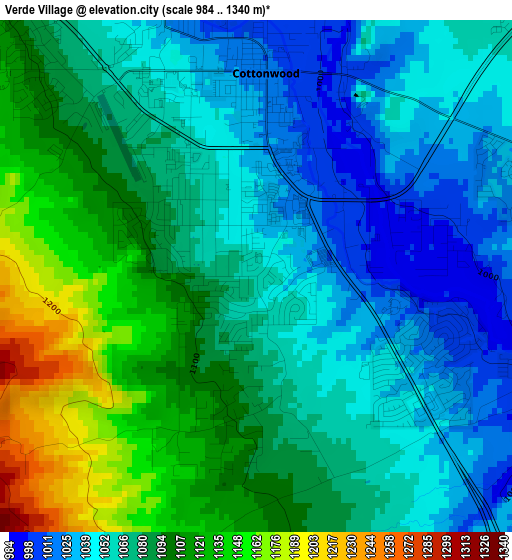
Below is the Elevation map of Verde Village, which displays elevation range with different colors. Scale of the first map is from 984 to 1340 m (3228 to 4396 ft) with average elevation of 1078.3 meters (=3538 ft) [note 1]
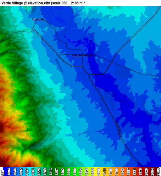
These maps also provides idea of topography and contour of this city, they are displayed at different zoom levels. More info about maps, scale and edge coordinates you can find below images.
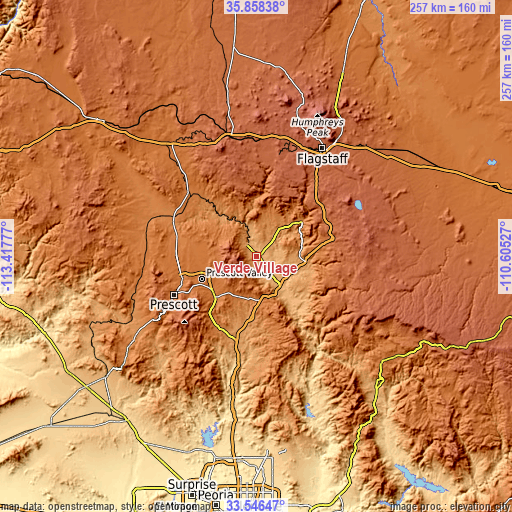
| \ | Map #1 | Map #2 | Topo.Map |
| Scale [m] | 984..1340 m | 960..2108 m | × |
| Scale [ft] | 3228..4396 ft | 3150..6916 ft | × |
| Average | 1078.3 m = 3538 ft | 1171 m = 3842 ft | × |
| Width | 8.03 km = 5 mi | 16.07 km = 10 mi | 257.1 km = 159.8 mi |
| Height | 8.03 km = 5 mi | 16.07 km = 10 mi | 257.1 km = 159.8 mi |
| ↑Max Latitude | 34.746617° | 34.782718° | 35.85838° |
| Latitude at center | 34.7105° | 34.7105° | 34.7105° |
| ↓Min Latitude | 34.674367° | 34.638219° | 33.54647° |
| ← Min Longitude | -112.055465° | -112.099411° | -113.41777° |
| Longitude center | -112.01152° | -112.01152° | -112.01152° |
| →Max Longitude | -111.967575° | -111.923629° | -110.60527° |
Nearby cities:
Cities around Verde Village sort by population:
• Prescott Valley elevation 1529 m
30 km,  248°
248°
• Cottonwood 1016 m
3.2 km,  2°
2°
• West Sedona 1354 m
25.6 km,  47°
47°
• Camp Verde 959 m
21.8 km,  138°
138°
• Sedona 1323 m
28.9 km, 52°
• Big Park 1239 m
24 km,  71°
71°
• Village of Oak Creek (Big Park) 1239 m
24.1 km, 71°
• Lake Montezuma 1051 m
23.1 km,  112°
112°
• Clarkdale 1088 m
8 km,  327°
327°
• Dewey-Humboldt 1395 m
29.1 km,  226°
226°
• Cornville 1011 m
8.3 km,  84°
84°
• Mayer 1353 m
40.4 km,  210°
210°
Multilingual:
 En español:
Verde Village elevación 1057 m.
 En France:
Verde Village élévation 1057 m.
 Auf Deutsch:
Verde Village höhe über dem Meeresspiegel ist 1057 m.

Sources and notes:
- [note 1] Map square and city borders are not equal. Map elevation data is calculated only from area inside that square.
- [src 1] Elevation data from geonames database provided with same terms of usage.
- [src 2] The elevation map of Verde Village is generated using elevation data from NASA's 3 arcsec (90m) resolution SRTM data.
- [src 3] Base (background) map © OpenStreetMap contributors tiles are generated by Geofabrik and OpenTopoMap.
Copyright & License:
This Verde Village Elevation Map is licensed under CC BY-SA. You may reuse any part from this page, if you give a proper credit by linking to this URL:
 More info on terms of use page.