‘Āhuimanu elevation
‘Āhuimanu (Hawaii, Honolulu County), United States elevation is 33 meters and ‘Āhuimanu elevation in feet is 108 ft above sea level [src 1]. ‘Āhuimanu is a populated place (feature code) with elevation that is 246 meters (807 ft) smaller than average city elevation in United States.
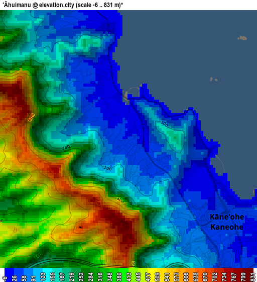
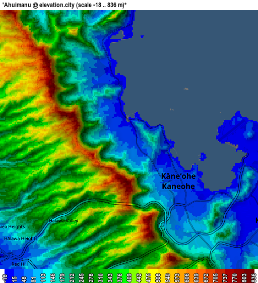
Below is the Elevation map of ‘Āhuimanu, which displays elevation range with different colors. Scale of the first map is from -6 to 831 m (-20 to 2726 ft) with average elevation of 234.3 meters (=769 ft) [note 1]
These maps also provides idea of topography and contour of this city, they are displayed at different zoom levels. More info about maps, scale and edge coordinates you can find below images.
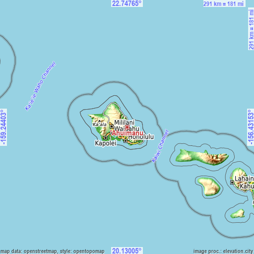
| \ | Map #1 | Map #2 | Topo.Map |
| Scale [m] | -6..831 m | -18..836 m | × |
| Scale [ft] | -20..2726 ft | -59..2743 ft | × |
| Average | 234.3 m = 769 ft | 258.9 m = 849 ft | × |
| Width | 9.1 km = 5.7 mi | 18.19 km = 11.3 mi | 291 km = 180.8 mi |
| Height | 9.1 km = 5.7 mi | 18.19 km = 11.3 mi | 291.1 km = 180.9 mi |
| ↑Max Latitude | 21.485617° | 21.526503° | 22.74765° |
| Latitude at center | 21.44472° | 21.44472° | 21.44472° |
| ↓Min Latitude | 21.403811° | 21.362891° | 20.13005° |
| ← Min Longitude | -157.881725° | -157.925671° | -159.24403° |
| Longitude center | -157.83778° | -157.83778° | -157.83778° |
| →Max Longitude | -157.793835° | -157.749889° | -156.43153° |
Nearby cities:
Cities around ‘Āhuimanu sort by population:
• Kailua elevation 8 m
11.1 km,  115°
115°
• Kaneohe 46 m
6.4 km,  141°
141°
• Hālawa 58 m
11.3 km,  230°
230°
• Waimalu 121 m
11.8 km,  247°
247°
• Hālawa Heights 74 m
10.8 km, 226°
• Marine Corps Base Hawaii - MCBH 6 m
9.1 km,  90°
90°
• ‘Aiea 36 m
12.1 km, 234°
• He‘eia 7 m
2.7 km,  125°
125°
• Kahalu‘u 20 m
1.6 km,  334°
334°
• Maunawili 30 m
10.6 km, 138°
• Ka‘a‘awa 4 m
12.3 km,  353°
353°
• Punalu‘u 10 m
14.5 km,  344°
344°
Multilingual:
 En español:
‘Āhuimanu elevación 33 m.
 En France:
‘Āhuimanu élévation 33 m.
 Auf Deutsch:
‘Āhuimanu höhe über dem Meeresspiegel ist 33 m.

Sources and notes:
- [note 1] Map square and city borders are not equal. Map elevation data is calculated only from area inside that square.
- [src 1] Elevation data from geonames database provided with same terms of usage.
- [src 2] The elevation map of ‘Āhuimanu is generated using elevation data from NASA's 3 arcsec (90m) resolution SRTM data.
- [src 3] Base (background) map © OpenStreetMap contributors tiles are generated by Geofabrik and OpenTopoMap.
Copyright & License:
This ‘Āhuimanu Elevation Map is licensed under CC BY-SA. You may reuse any part from this page, if you give a proper credit by linking to this URL:
 More info on terms of use page.