Ranchettes elevation
Ranchettes (Wyoming, Laramie County), United States elevation is 1888 meters and Ranchettes elevation in feet is 6194 ft above sea level [src 1]. Ranchettes is a populated place (feature code) with elevation that is 1609 meters (5279 ft) bigger than average city elevation in United States.
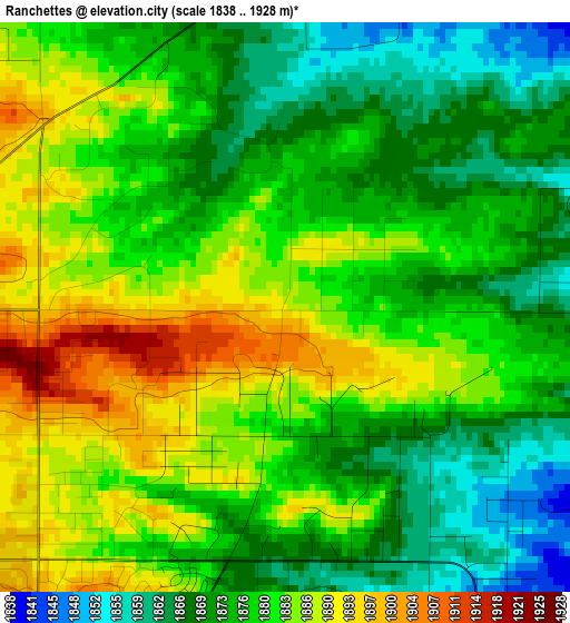
Below is the Elevation map of Ranchettes, which displays elevation range with different colors. Scale of the first map is from 1838 to 1928 m (6030 to 6325 ft) with average elevation of 1878.2 meters (=6162 ft) [note 1]
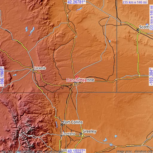
These maps also provides idea of topography and contour of this city, they are displayed at different zoom levels. More info about maps, scale and edge coordinates you can find below images.
| \ | Map #1 | Map #2 | Topo.Map |
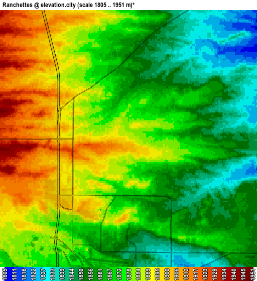
| Scale [m] | 1838..1928 m | 1805..1951 m | × |
| Scale [ft] | 6030..6325 ft | 5922..6401 ft | × |
| Average | 1878.2 m = 6162 ft | 1872.8 m = 6144 ft | × |
| Width | 7.35 km = 4.6 mi | 14.7 km = 9.1 mi | 235.2 km = 146.1 mi |
| Height | 7.35 km = 4.6 mi | 14.7 km = 9.1 mi | 235.2 km = 146.1 mi |
| ↑Max Latitude | 41.251637° | 41.284668° | 42.26781° |
| Latitude at center | 41.21859° | 41.21859° | 41.21859° |
| ↓Min Latitude | 41.185526° | 41.152445° | 40.15227° |
| ← Min Longitude | -104.834195° | -104.878141° | -106.1965° |
| Longitude center | -104.79025° | -104.79025° | -104.79025° |
| →Max Longitude | -104.746305° | -104.702359° | -103.384° |
Nearby cities:
Cities around Ranchettes sort by population:
• Fort Collins elevation 1531 m
74.6 km,  199°
199°
• Cheyenne 1866 m
9.1 km, 196°
• Laramie 2190 m
67.7 km,  278°
278°
• Windsor 1468 m
82.9 km,  186°
186°
• Wellington 1588 m
60.1 km, 197°
• Eaton 1476 m
76.8 km,  175°
175°
• South Greeley 1845 m
13.6 km, 185°
• Severance 1494 m
77.4 km, 183°
• Fox Farm-College 1828 m
11.9 km, 178°
• Laporte 1546 m
72.1 km, 203°
• Ault 1508 m
70.9 km, 176°
• Pine Bluffs 1539 m
60.5 km,  93°
93°
Multilingual:
 En español:
Ranchettes elevación 1888 m.
 En France:
Ranchettes élévation 1888 m.
 Auf Deutsch:
Ranchettes höhe über dem Meeresspiegel ist 1888 m.

Sources and notes:
- [note 1] Map square and city borders are not equal. Map elevation data is calculated only from area inside that square.
- [src 1] Elevation data from geonames database provided with same terms of usage.
- [src 2] The elevation map of Ranchettes is generated using elevation data from NASA's 3 arcsec (90m) resolution SRTM data.
- [src 3] Base (background) map © OpenStreetMap contributors tiles are generated by Geofabrik and OpenTopoMap.
Copyright & License:
This Ranchettes Elevation Map is licensed under CC BY-SA. You may reuse any part from this page, if you give a proper credit by linking to this URL:
 More info on terms of use page.