Woodland elevation
Woodland (Washington, Cowlitz County), United States elevation is 10 meters and Woodland elevation in feet is 33 ft above sea level [src 1]. Woodland is a populated place (feature code) with elevation that is 269 meters (883 ft) smaller than average city elevation in United States.
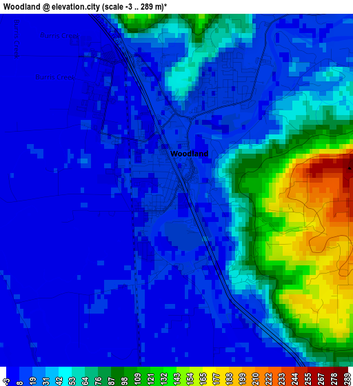
Below is the Elevation map of Woodland, which displays elevation range with different colors. Scale of the first map is from -3 to 289 m (-10 to 948 ft) with average elevation of 38.9 meters (=128 ft) [note 1]
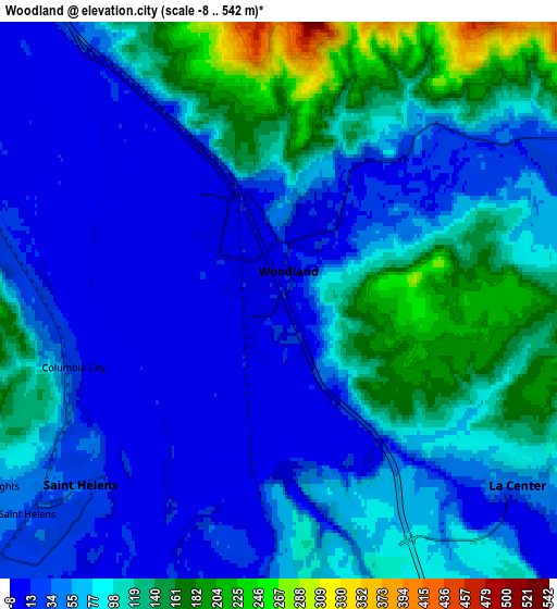
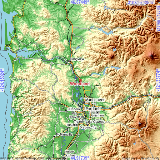
These maps also provides idea of topography and contour of this city, they are displayed at different zoom levels. More info about maps, scale and edge coordinates you can find below images.
| \ | Map #1 | Map #2 | Topo.Map |
| Scale [m] | -3..289 m | -8..542 m | × |
| Scale [ft] | -10..948 ft | -26..1778 ft | × |
| Average | 38.9 m = 128 ft | 74.7 m = 245 ft | × |
| Width | 6.8 km = 4.2 mi | 13.6 km = 8.5 mi | 217.6 km = 135.2 mi |
| Height | 6.8 km = 4.2 mi | 13.6 km = 8.5 mi | 217.6 km = 135.2 mi |
| ↑Max Latitude | 45.935131° | 45.965685° | 46.87449° |
| Latitude at center | 45.90456° | 45.90456° | 45.90456° |
| ↓Min Latitude | 45.873972° | 45.843367° | 44.91739° |
| ← Min Longitude | -122.787935° | -122.831881° | -124.15024° |
| Longitude center | -122.74399° | -122.74399° | -122.74399° |
| →Max Longitude | -122.700045° | -122.656099° | -121.33774° |
Nearby cities:
Cities around Woodland sort by population:
• Battle Ground elevation 93 m
21.3 km,  130°
130°
• Saint Helens 31 m
6.6 km,  227°
227°
• Mount Vista 72 m
20.8 km,  155°
155°
• Scappoose 24 m
19.7 km,  211°
211°
• Ridgefield 36 m
9.9 km,  179°
179°
• La Center 34 m
7.4 km, 129°
• Meadow Glade 86 m
21.6 km,  138°
138°
• Kalama 13 m
13.9 km,  326°
326°
• Columbia City 16 m
5.1 km,  251°
251°
• Warren 16 m
12.5 km,  220°
220°
• Lewisville 130 m
20.1 km,  121°
121°
• Dollar Corner 67 m
17.8 km, 141°
Multilingual:
 En español:
Woodland elevación 10 m.
 En France:
Woodland élévation 10 m.


Sources and notes:
- [note 1] Map square and city borders are not equal. Map elevation data is calculated only from area inside that square.
- [src 1] Elevation data from geonames database provided with same terms of usage.
- [src 2] The elevation map of Woodland is generated using elevation data from NASA's 3 arcsec (90m) resolution SRTM data.
- [src 3] Base (background) map © OpenStreetMap contributors tiles are generated by Geofabrik and OpenTopoMap.
Copyright & License:
This Woodland Elevation Map is licensed under CC BY-SA. You may reuse any part from this page, if you give a proper credit by linking to this URL:
 More info on terms of use page.