Trentwood elevation
Trentwood (Washington, Spokane County), United States elevation is 616 meters and Trentwood elevation in feet is 2021 ft above sea level [src 1]. Trentwood is a section of populated place (feature code) with elevation that is 337 meters (1106 ft) bigger than average city elevation in United States.
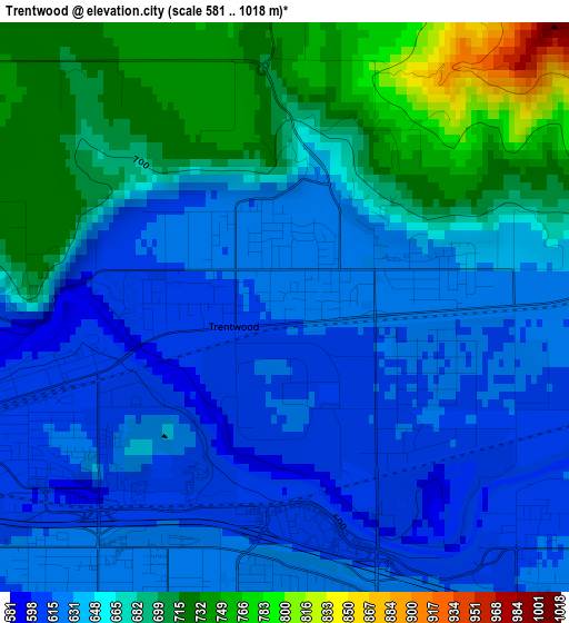
Below is the Elevation map of Trentwood, which displays elevation range with different colors. Scale of the first map is from 581 to 1018 m (1906 to 3340 ft) with average elevation of 657.7 meters (=2158 ft) [note 1]
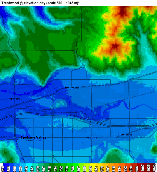
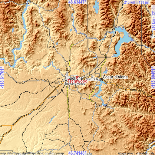
These maps also provides idea of topography and contour of this city, they are displayed at different zoom levels. More info about maps, scale and edge coordinates you can find below images.
| \ | Map #1 | Map #2 | Topo.Map |
| Scale [m] | 581..1018 m | 570..1043 m | × |
| Scale [ft] | 1906..3340 ft | 1870..3422 ft | × |
| Average | 657.7 m = 2158 ft | 671.9 m = 2204 ft | × |
| Width | 6.58 km = 4.1 mi | 13.15 km = 8.2 mi | 210.5 km = 130.8 mi |
| Height | 6.58 km = 4.1 mi | 13.15 km = 8.2 mi | 210.5 km = 130.8 mi |
| ↑Max Latitude | 47.726129° | 47.755682° | 48.63447° |
| Latitude at center | 47.69656° | 47.69656° | 47.69656° |
| ↓Min Latitude | 47.666974° | 47.637371° | 46.74148° |
| ← Min Longitude | -117.254705° | -117.298651° | -118.61701° |
| Longitude center | -117.21076° | -117.21076° | -117.21076° |
| →Max Longitude | -117.166815° | -117.122869° | -115.80451° |
Nearby cities:
Cities around Trentwood sort by population:
• Spokane elevation 530 m
16.9 km,  255°
255°
• Spokane Valley 610 m
3.4 km,  219°
219°
• Opportunity 612 m
5.6 km,  202°
202°
• Veradale 614 m
5.2 km,  177°
177°
• Dishman 609 m
6.3 km,  230°
230°
• Liberty Lake 618 m
7.3 km,  108°
108°
• Fairwood 551 m
17.3 km,  296°
296°
• Mead 578 m
13.4 km,  306°
306°
• Otis Orchards-East Farms 634 m
9.9 km,  81°
81°
• Country Homes 593 m
15.6 km,  291°
291°
• Town and Country 626 m
16.1 km,  282°
282°
• Millwood 601 m
5.6 km,  252°
252°
Multilingual:
 En español:
Trentwood elevación 616 m.
 En France:
Trentwood élévation 616 m.
 Auf Deutsch:
Trentwood höhe über dem Meeresspiegel ist 616 m.

Sources and notes:
- [note 1] Map square and city borders are not equal. Map elevation data is calculated only from area inside that square.
- [src 1] Elevation data from geonames database provided with same terms of usage.
- [src 2] The elevation map of Trentwood is generated using elevation data from NASA's 3 arcsec (90m) resolution SRTM data.
- [src 3] Base (background) map © OpenStreetMap contributors tiles are generated by Geofabrik and OpenTopoMap.
Copyright & License:
This Trentwood Elevation Map is licensed under CC BY-SA. You may reuse any part from this page, if you give a proper credit by linking to this URL:
 More info on terms of use page.