Tanner elevation
Tanner (Washington, King County), United States elevation is 161 meters and Tanner elevation in feet is 528 ft above sea level [src 1]. Tanner is a populated place (feature code) with elevation that is 118 meters (387 ft) smaller than average city elevation in United States.
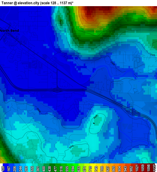
Below is the Elevation map of Tanner, which displays elevation range with different colors. Scale of the first map is from 128 to 1137 m (420 to 3730 ft) with average elevation of 269.5 meters (=884 ft) [note 1]
These maps also provides idea of topography and contour of this city, they are displayed at different zoom levels. More info about maps, scale and edge coordinates you can find below images.
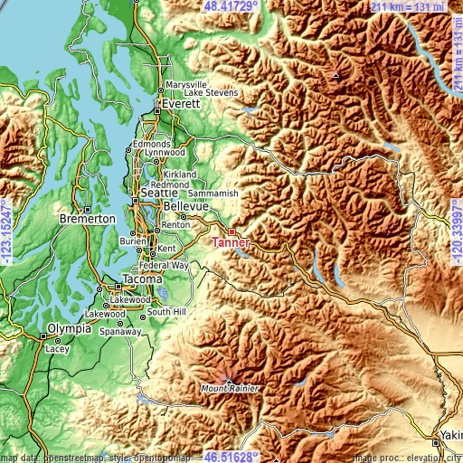
| \ | Map #1 | Topo.Map |
| Scale [m] | 128..1137 m | × |
| Scale [ft] | 420..3730 ft | × |
| Average | 269.5 m = 884 ft | × |
| Width | 6.61 km = 4.1 mi | 211.4 km = 131.4 mi |
| Height | 6.61 km = 4.1 mi | 211.4 km = 131.4 mi |
| ↑Max Latitude | 47.505075° | 48.41729° |
| Latitude at center | 47.47538° | 47.47538° |
| ↓Min Latitude | 47.445669° | 46.51628° |
| ← Min Longitude | -121.790165° | -123.15247° |
| Longitude center | -121.74622° | -121.74622° |
| →Max Longitude | -121.702275° | -120.33997° |
Nearby cities:
Cities around Tanner sort by population:
• Issaquah elevation 33 m
22.4 km,  285°
285°
• Snoqualmie 130 m
8.4 km,  314°
314°
• Klahanie 138 m
22.4 km,  298°
298°
• North Bend 135 m
3.8 km, 306°
• Hobart 176 m
18.1 km,  250°
250°
• Mirrormont 249 m
18.8 km,  265°
265°
• Riverbend 158 m
1 km,  197°
197°
• Fall City 29 m
14.8 km, 313°
• Carnation 23 m
22.9 km,  326°
326°
• Wilderness Rim 319 m
3.6 km,  208°
208°
• Ames Lake 110 m
24.1 km,  316°
316°
• Ravensdale 190 m
22.5 km,  232°
232°
Multilingual:
 En español:
Tanner elevación 161 m.
 En France:
Tanner élévation 161 m.


Sources and notes:
- [note 1] Map square and city borders are not equal. Map elevation data is calculated only from area inside that square.
- [src 1] Elevation data from geonames database provided with same terms of usage.
- [src 2] The elevation map of Tanner is generated using elevation data from NASA's 3 arcsec (90m) resolution SRTM data.
- [src 3] Base (background) map © OpenStreetMap contributors tiles are generated by Geofabrik and OpenTopoMap.
Copyright & License:
This Tanner Elevation Map is licensed under CC BY-SA. You may reuse any part from this page, if you give a proper credit by linking to this URL:
 More info on terms of use page.