Summit elevation
Summit (Washington, Pierce County), United States elevation is 141 meters and Summit elevation in feet is 463 ft above sea level [src 1]. Summit is a populated place (feature code) with elevation that is 138 meters (453 ft) smaller than average city elevation in United States.
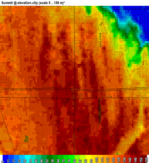
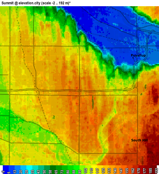
Below is the Elevation map of Summit, which displays elevation range with different colors. Scale of the first map is from 5 to 158 m (16 to 518 ft) with average elevation of 122.4 meters (=402 ft) [note 1]
These maps also provides idea of topography and contour of this city, they are displayed at different zoom levels. More info about maps, scale and edge coordinates you can find below images.
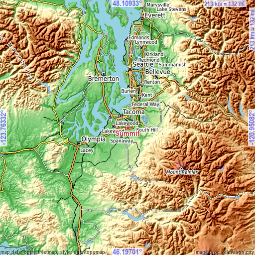
| \ | Map #1 | Map #2 | Topo.Map |
| Scale [m] | 5..158 m | -2..192 m | × |
| Scale [ft] | 16..518 ft | -7..630 ft | × |
| Average | 122.4 m = 402 ft | 104.7 m = 344 ft | × |
| Width | 6.64 km = 4.1 mi | 13.29 km = 8.3 mi | 212.6 km = 132.1 mi |
| Height | 6.64 km = 4.1 mi | 13.29 km = 8.3 mi | 212.6 km = 132.1 mi |
| ↑Max Latitude | 47.191641° | 47.221496° | 48.10933° |
| Latitude at center | 47.16177° | 47.16177° | 47.16177° |
| ↓Min Latitude | 47.131882° | 47.101977° | 46.19701° |
| ← Min Longitude | -122.401015° | -122.444961° | -123.76332° |
| Longitude center | -122.35707° | -122.35707° | -122.35707° |
| →Max Longitude | -122.313125° | -122.269179° | -120.95082° |
Nearby cities:
Cities around Summit sort by population:
• South Hill elevation 165 m
7 km,  109°
109°
• Puyallup 11 m
5.5 km,  61°
61°
• Parkland 114 m
5.9 km,  263°
263°
• Spanaway 111 m
8.7 km,  222°
222°
• Frederickson 119 m
7.3 km,  180°
180°
• Fife 2 m
8.6 km,  0°
0°
• Midland 126 m
3.7 km,  279°
279°
• Waller 121 m
4.4 km,  347°
347°
• Summit View 155 m
2.9 km,  172°
172°
• Alderton 25 m
9.7 km,  84°
84°
• North Puyallup 15 m
7.5 km,  48°
48°
• McMillin 36 m
9.4 km,  104°
104°
Multilingual:
 En español:
Summit elevación 141 m.
 En France:
Summit élévation 141 m.


Sources and notes:
- [note 1] Map square and city borders are not equal. Map elevation data is calculated only from area inside that square.
- [src 1] Elevation data from geonames database provided with same terms of usage.
- [src 2] The elevation map of Summit is generated using elevation data from NASA's 3 arcsec (90m) resolution SRTM data.
- [src 3] Base (background) map © OpenStreetMap contributors tiles are generated by Geofabrik and OpenTopoMap.
Copyright & License:
This Summit Elevation Map is licensed under CC BY-SA. You may reuse any part from this page, if you give a proper credit by linking to this URL:
 More info on terms of use page.