Richland elevation
Richland (Washington, Benton County), United States elevation is 115 meters and Richland elevation in feet is 377 ft above sea level [src 1]. Richland is a populated place (feature code) with elevation that is 164 meters (538 ft) smaller than average city elevation in United States.
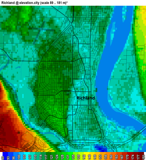
Below is the Elevation map of Richland, which displays elevation range with different colors. Scale of the first map is from 89 to 181 m (292 to 594 ft) with average elevation of 116.5 meters (=382 ft) [note 1]
These maps also provides idea of topography and contour of this city, they are displayed at different zoom levels. More info about maps, scale and edge coordinates you can find below images.
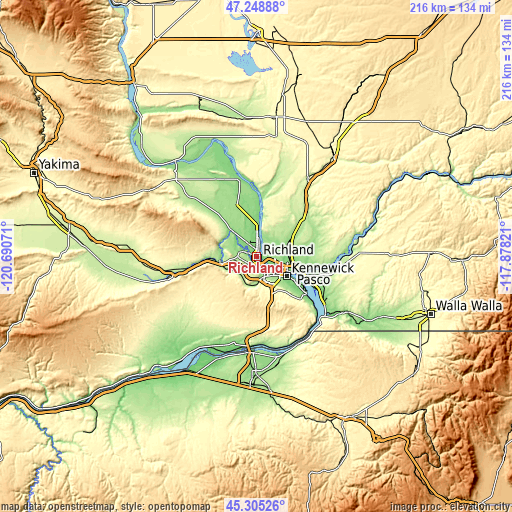
| \ | Map #1 | Map #2 | Topo.Map |
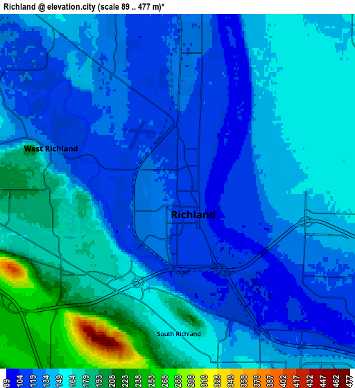
| Scale [m] | 89..181 m | 89..477 m | × |
| Scale [ft] | 292..594 ft | 292..1565 ft | × |
| Average | 116.5 m = 382 ft | 145.6 m = 478 ft | × |
| Width | 6.75 km = 4.2 mi | 13.51 km = 8.4 mi | 216.1 km = 134.3 mi |
| Height | 6.75 km = 4.2 mi | 13.51 km = 8.4 mi | 216.1 km = 134.3 mi |
| ↑Max Latitude | 46.316051° | 46.346394° | 47.24888° |
| Latitude at center | 46.28569° | 46.28569° | 46.28569° |
| ↓Min Latitude | 46.255313° | 46.224918° | 45.30526° |
| ← Min Longitude | -119.328405° | -119.372351° | -120.69071° |
| Longitude center | -119.28446° | -119.28446° | -119.28446° |
| →Max Longitude | -119.240515° | -119.196569° | -117.87821° |
Nearby cities:
Cities around Richland sort by population:
• Kennewick elevation 126 m
14 km,  126°
126°
• Pasco 115 m
15 km,  109°
109°
• West Richland 126 m
6.3 km,  289°
289°
• Umatilla 98 m
41.2 km,  186°
186°
• Finley 106 m
24.2 km, 127°
• Prosser 203 m
38.3 km,  256°
256°
• West Pasco 107 m
9 km,  119°
119°
• Burbank 114 m
22.9 km, 114°
• Benton City 152 m
15.8 km, 260°
• Highland 331 m
21.6 km,  142°
142°
• Irrigon 92 m
46.2 km,  200°
200°
• Basin City 211 m
35.7 km,  16°
16°
Multilingual:
 En español:
Richland elevación 115 m.
 En France:
Richland élévation 115 m.
 Auf Deutsch:
Richland höhe über dem Meeresspiegel ist 115 m.

Sources and notes:
- [note 1] Map square and city borders are not equal. Map elevation data is calculated only from area inside that square.
- [src 1] Elevation data from geonames database provided with same terms of usage.
- [src 2] The elevation map of Richland is generated using elevation data from NASA's 3 arcsec (90m) resolution SRTM data.
- [src 3] Base (background) map © OpenStreetMap contributors tiles are generated by Geofabrik and OpenTopoMap.
Copyright & License:
This Richland Elevation Map is licensed under CC BY-SA. You may reuse any part from this page, if you give a proper credit by linking to this URL:
 More info on terms of use page.