Colville elevation
Colville (Washington, Stevens County), United States elevation is 490 meters and Colville elevation in feet is 1608 ft above sea level [src 1]. Colville is a seat of a second-order administrative division (feature code) with elevation that is 211 meters (692 ft) bigger than average city elevation in United States.
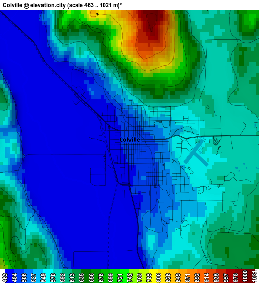
Below is the Elevation map of Colville, which displays elevation range with different colors. Scale of the first map is from 463 to 1021 m (1519 to 3350 ft) with average elevation of 561.9 meters (=1844 ft) [note 1]
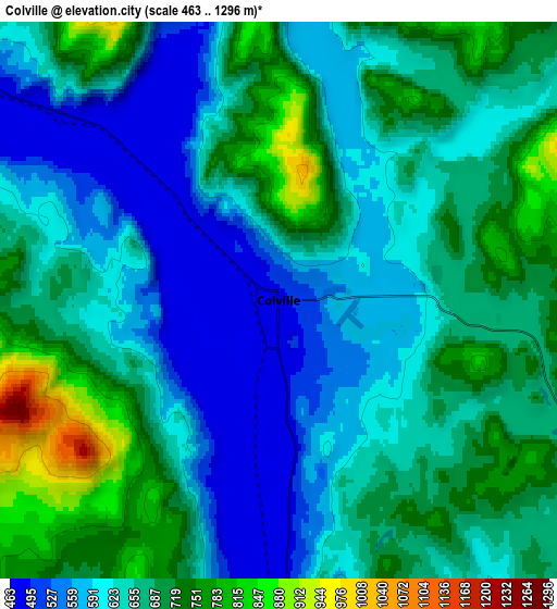
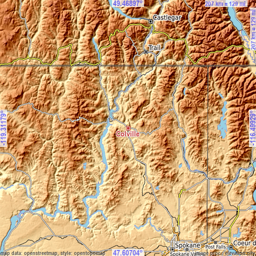
These maps also provides idea of topography and contour of this city, they are displayed at different zoom levels. More info about maps, scale and edge coordinates you can find below images.
| \ | Map #1 | Map #2 | Topo.Map |
| Scale [m] | 463..1021 m | 463..1296 m | × |
| Scale [ft] | 1519..3350 ft | 1519..4252 ft | × |
| Average | 561.9 m = 1844 ft | 652.3 m = 2140 ft | × |
| Width | 6.47 km = 4 mi | 12.94 km = 8 mi | 207 km = 128.6 mi |
| Height | 6.47 km = 4 mi | 12.94 km = 8 mi | 207 km = 128.6 mi |
| ↑Max Latitude | 48.575654° | 48.604721° | 49.46897° |
| Latitude at center | 48.54657° | 48.54657° | 48.54657° |
| ↓Min Latitude | 48.517469° | 48.488352° | 47.60704° |
| ← Min Longitude | -117.949485° | -117.993431° | -119.31179° |
| Longitude center | -117.90554° | -117.90554° | -117.90554° |
| →Max Longitude | -117.861595° | -117.817649° | -116.49929° |
Nearby cities:
Cities around Colville sort by population:
• Fairwood elevation 551 m
94 km,  157°
157°
• Mead 578 m
95.8 km,  154°
154°
• Country Homes 593 m
96.2 km, 157°
• Town and Country 626 m
97.9 km, 158°
• Deer Park 645 m
73.1 km, 154°
• Chewelah 509 m
33.2 km, 154°
• Newport 652 m
75.6 km,  122°
122°
• Spirit Lake 783 m
100.3 km,  130°
130°
• Priest River 653 m
83.9 km, 118°
• Davenport 723 m
100.9 km,  190°
190°
• Kettle Falls 494 m
13.2 km,  302°
302°
• Republic 782 m
62.2 km,  280°
280°
Multilingual:
 En español:
Colville elevación 490 m.
 En France:
Colville élévation 490 m.
 Auf Deutsch:
Colville höhe über dem Meeresspiegel ist 490 m.

Sources and notes:
- [note 1] Map square and city borders are not equal. Map elevation data is calculated only from area inside that square.
- [src 1] Elevation data from geonames database provided with same terms of usage.
- [src 2] The elevation map of Colville is generated using elevation data from NASA's 3 arcsec (90m) resolution SRTM data.
- [src 3] Base (background) map © OpenStreetMap contributors tiles are generated by Geofabrik and OpenTopoMap.
Copyright & License:
This Colville Elevation Map is licensed under CC BY-SA. You may reuse any part from this page, if you give a proper credit by linking to this URL:
 More info on terms of use page.