Smithfield elevation
Smithfield (Utah, Cache County), United States elevation is 1403 meters and Smithfield elevation in feet is 4603 ft above sea level [src 1]. Smithfield is a populated place (feature code) with elevation that is 1124 meters (3688 ft) bigger than average city elevation in United States.
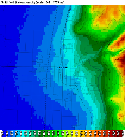
Below is the Elevation map of Smithfield, which displays elevation range with different colors. Scale of the first map is from 1344 to 1759 m (4409 to 5771 ft) with average elevation of 1424.5 meters (=4674 ft) [note 1]
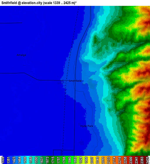
These maps also provides idea of topography and contour of this city, they are displayed at different zoom levels. More info about maps, scale and edge coordinates you can find below images.
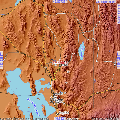
| \ | Map #1 | Map #2 | Topo.Map |
| Scale [m] | 1344..1759 m | 1339..2425 m | × |
| Scale [ft] | 4409..5771 ft | 4393..7956 ft | × |
| Average | 1424.5 m = 4674 ft | 1509.2 m = 4951 ft | × |
| Width | 7.28 km = 4.5 mi | 14.56 km = 9 mi | 233 km = 144.8 mi |
| Height | 7.28 km = 4.5 mi | 14.56 km = 9 mi | 233 km = 144.8 mi |
| ↑Max Latitude | 41.870992° | 41.903708° | 42.87737° |
| Latitude at center | 41.83826° | 41.83826° | 41.83826° |
| ↓Min Latitude | 41.805511° | 41.772745° | 40.782° |
| ← Min Longitude | -111.876665° | -111.920611° | -113.23897° |
| Longitude center | -111.83272° | -111.83272° | -111.83272° |
| →Max Longitude | -111.788775° | -111.744829° | -110.42647° |
Nearby cities:
Cities around Smithfield sort by population:
• Logan elevation 1381 m
11.4 km,  180°
180°
• North Logan 1432 m
8 km,  163°
163°
• Hyrum 1434 m
22.8 km, 184°
• Providence 1401 m
14.7 km,  174°
174°
• Nibley 1390 m
18.2 km, 180°
• Hyde Park 1388 m
4.5 km, 165°
• Richmond 1410 m
9.5 km,  9°
9°
• Millville 1404 m
17.4 km, 177°
• River Heights 1393 m
13 km, 175°
• Lewiston 1378 m
15.4 km,  352°
352°
• Benson 1350 m
9.9 km,  235°
235°
• Mendon 1371 m
18.7 km,  220°
220°
Multilingual:
 En español:
Smithfield elevación 1403 m.
 En France:
Smithfield élévation 1403 m.
 Auf Deutsch:
Smithfield höhe über dem Meeresspiegel ist 1403 m.

Sources and notes:
- [note 1] Map square and city borders are not equal. Map elevation data is calculated only from area inside that square.
- [src 1] Elevation data from geonames database provided with same terms of usage.
- [src 2] The elevation map of Smithfield is generated using elevation data from NASA's 3 arcsec (90m) resolution SRTM data.
- [src 3] Base (background) map © OpenStreetMap contributors tiles are generated by Geofabrik and OpenTopoMap.
Copyright & License:
This Smithfield Elevation Map is licensed under CC BY-SA. You may reuse any part from this page, if you give a proper credit by linking to this URL:
 More info on terms of use page.