Mapleton elevation
Mapleton (Utah, Utah County), United States elevation is 1448 meters and Mapleton elevation in feet is 4751 ft above sea level [src 1]. Mapleton is a populated place (feature code) with elevation that is 1169 meters (3835 ft) bigger than average city elevation in United States.
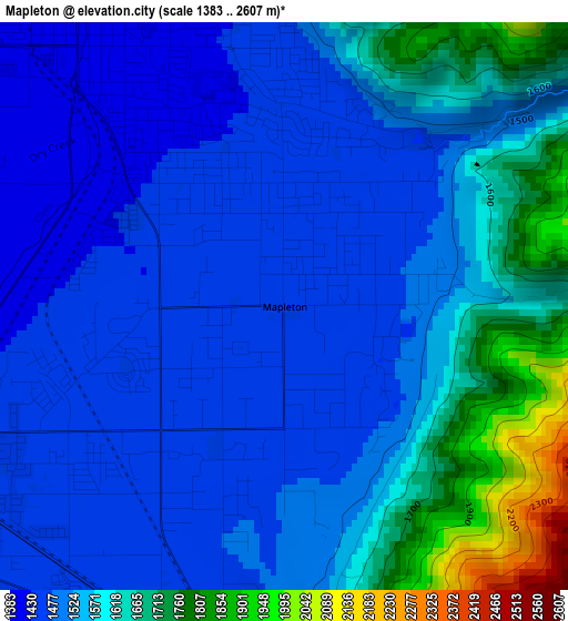
Below is the Elevation map of Mapleton, which displays elevation range with different colors. Scale of the first map is from 1383 to 2607 m (4537 to 8553 ft) with average elevation of 1548.9 meters (=5082 ft) [note 1]
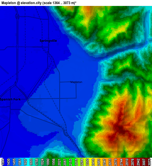
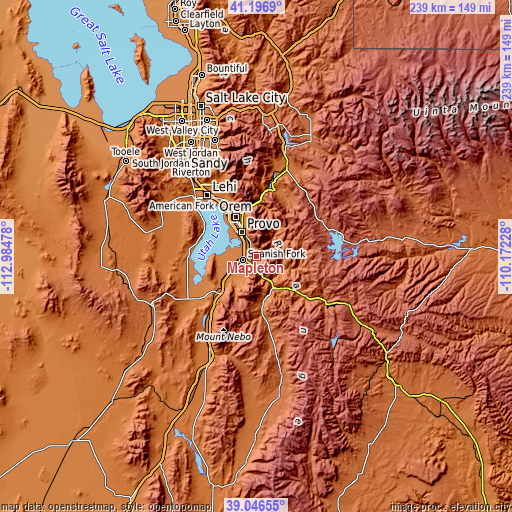
These maps also provides idea of topography and contour of this city, they are displayed at different zoom levels. More info about maps, scale and edge coordinates you can find below images.
| \ | Map #1 | Map #2 | Topo.Map |
| Scale [m] | 1383..2607 m | 1364..3073 m | × |
| Scale [ft] | 4537..8553 ft | 4475..10082 ft | × |
| Average | 1548.9 m = 5082 ft | 1729.6 m = 5675 ft | × |
| Width | 7.47 km = 4.6 mi | 14.94 km = 9.3 mi | 239.1 km = 148.6 mi |
| Height | 7.47 km = 4.6 mi | 14.94 km = 9.3 mi | 239.1 km = 148.6 mi |
| ↑Max Latitude | 40.163821° | 40.197396° | 41.1969° |
| Latitude at center | 40.13023° | 40.13023° | 40.13023° |
| ↓Min Latitude | 40.096622° | 40.062997° | 39.04655° |
| ← Min Longitude | -111.622475° | -111.666421° | -112.98478° |
| Longitude center | -111.57853° | -111.57853° | -111.57853° |
| →Max Longitude | -111.534585° | -111.490639° | -110.17228° |
Nearby cities:
Cities around Mapleton sort by population:
• Provo elevation 1394 m
13.4 km,  329°
329°
• Orem 1458 m
21 km, 331°
• Spanish Fork 1394 m
6.7 km,  255°
255°
• Springville 1401 m
4.8 km,  324°
324°
• Payson 1423 m
16.2 km,  233°
233°
• Santaquin 1519 m
24.6 km, 225°
• Salem 1405 m
11.8 km,  223°
223°
• Vineyard 1380 m
23.4 km, 322°
• Elk Ridge 1635 m
15.6 km,  212°
212°
• Woodland Hills 1710 m
14.1 km, 205°
• West Mountain 1388 m
19.4 km,  246°
246°
• Benjamin 1385 m
13.5 km, 254°
Multilingual:
 En español:
Mapleton elevación 1448 m.
 En France:
Mapleton élévation 1448 m.
 Auf Deutsch:
Mapleton höhe über dem Meeresspiegel ist 1448 m.

Sources and notes:
- [note 1] Map square and city borders are not equal. Map elevation data is calculated only from area inside that square.
- [src 1] Elevation data from geonames database provided with same terms of usage.
- [src 2] The elevation map of Mapleton is generated using elevation data from NASA's 3 arcsec (90m) resolution SRTM data.
- [src 3] Base (background) map © OpenStreetMap contributors tiles are generated by Geofabrik and OpenTopoMap.
Copyright & License:
This Mapleton Elevation Map is licensed under CC BY-SA. You may reuse any part from this page, if you give a proper credit by linking to this URL:
 More info on terms of use page.