Daniel elevation
Daniel (Utah, Wasatch County), United States elevation is 1745 meters and Daniel elevation in feet is 5725 ft above sea level [src 1]. Daniel is a populated place (feature code) with elevation that is 1466 meters (4810 ft) bigger than average city elevation in United States.
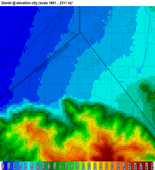
Below is the Elevation map of Daniel, which displays elevation range with different colors. Scale of the first map is from 1661 to 2311 m (5449 to 7582 ft) with average elevation of 1824.2 meters (=5985 ft) [note 1]
These maps also provides idea of topography and contour of this city, they are displayed at different zoom levels. More info about maps, scale and edge coordinates you can find below images.
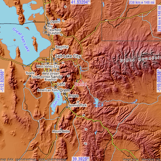
| \ | Map #1 | Topo.Map |
| Scale [m] | 1661..2311 m | × |
| Scale [ft] | 5449..7582 ft | × |
| Average | 1824.2 m = 5985 ft | × |
| Width | 7.43 km = 4.6 mi | 237.9 km = 147.8 mi |
| Height | 7.43 km = 4.6 mi | 237.9 km = 147.8 mi |
| ↑Max Latitude | 40.504213° | 41.53204° |
| Latitude at center | 40.47079° | 40.47079° |
| ↓Min Latitude | 40.437351° | 39.3925° |
| ← Min Longitude | -111.458575° | -112.82088° |
| Longitude center | -111.41463° | -111.41463° |
| →Max Longitude | -111.370685° | -110.00838° |
Nearby cities:
Cities around Daniel sort by population:
• Orem elevation 1458 m
30.6 km,  230°
230°
• Pleasant Grove 1416 m
29.9 km,  246°
246°
• Lindon 1418 m
29.5 km,  241°
241°
• Cedar Hills 1517 m
29.8 km,  257°
257°
• Heber City 1710 m
4 km,  1°
1°
• Park City 2151 m
20.7 km,  340°
340°
• Snyderville 2019 m
27.1 km, 336°
• Midway 1709 m
6.8 km,  312°
312°
• Silver Summit 1997 m
30.7 km,  348°
348°
• Kamas 1979 m
22.2 km,  30°
30°
• Oakley 1964 m
28.8 km,  19°
19°
• Francis 2002 m
19.2 km,  36°
36°
Multilingual:
 En español:
Daniel elevación 1745 m.
 En France:
Daniel élévation 1745 m.


Sources and notes:
- [note 1] Map square and city borders are not equal. Map elevation data is calculated only from area inside that square.
- [src 1] Elevation data from geonames database provided with same terms of usage.
- [src 2] The elevation map of Daniel is generated using elevation data from NASA's 3 arcsec (90m) resolution SRTM data.
- [src 3] Base (background) map © OpenStreetMap contributors tiles are generated by Geofabrik and OpenTopoMap.
Copyright & License:
This Daniel Elevation Map is licensed under CC BY-SA. You may reuse any part from this page, if you give a proper credit by linking to this URL:
 More info on terms of use page.