Coalville elevation
Coalville (Utah, Summit County), United States elevation is 1704 meters and Coalville elevation in feet is 5591 ft above sea level [src 1]. Coalville is a seat of a second-order administrative division (feature code) with elevation that is 1425 meters (4675 ft) bigger than average city elevation in United States.
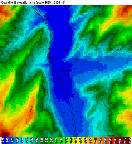
Below is the Elevation map of Coalville, which displays elevation range with different colors. Scale of the first map is from 1689 to 2134 m (5541 to 7001 ft) with average elevation of 1815.2 meters (=5955 ft) [note 1]
These maps also provides idea of topography and contour of this city, they are displayed at different zoom levels. More info about maps, scale and edge coordinates you can find below images.
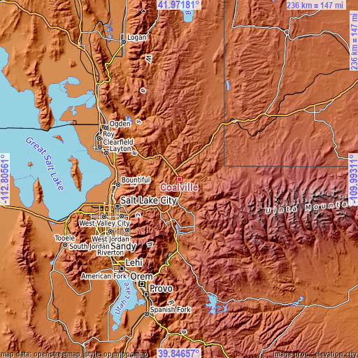
| \ | Map #1 | Topo.Map |
| Scale [m] | 1689..2134 m | × |
| Scale [ft] | 5541..7001 ft | × |
| Average | 1815.2 m = 5955 ft | × |
| Width | 7.38 km = 4.6 mi | 236.3 km = 146.8 mi |
| Height | 7.38 km = 4.6 mi | 236.3 km = 146.8 mi |
| ↑Max Latitude | 40.950929° | 41.97181° |
| Latitude at center | 40.91773° | 40.91773° |
| ↓Min Latitude | 40.884514° | 39.84657° |
| ← Min Longitude | -111.443305° | -112.80561° |
| Longitude center | -111.39936° | -111.39936° |
| →Max Longitude | -111.355415° | -109.99311° |
Nearby cities:
Cities around Coalville sort by population:
• Bountiful elevation 1337 m
40.6 km,  265°
265°
• Farmington 1315 m
41.6 km,  279°
279°
• Centerville 1332 m
39.7 km, 270°
• Park City 2151 m
31.3 km,  195°
195°
• Summit Park 2111 m
26.2 km,  223°
223°
• Snyderville 2019 m
27.6 km,  206°
206°
• Morgan 1548 m
26.8 km,  299°
299°
• Silver Summit 1997 m
21 km, 200°
• Mountain Green 1488 m
41.3 km,  307°
307°
• Kamas 1979 m
32.1 km,  161°
161°
• Oakley 1964 m
24.1 km, 159°
• Francis 2002 m
35.6 km, 163°
Multilingual:
 En español:
Coalville elevación 1704 m.
 En France:
Coalville élévation 1704 m.
 Auf Deutsch:
Coalville höhe über dem Meeresspiegel ist 1704 m.

Sources and notes:
- [note 1] Map square and city borders are not equal. Map elevation data is calculated only from area inside that square.
- [src 1] Elevation data from geonames database provided with same terms of usage.
- [src 2] The elevation map of Coalville is generated using elevation data from NASA's 3 arcsec (90m) resolution SRTM data.
- [src 3] Base (background) map © OpenStreetMap contributors tiles are generated by Geofabrik and OpenTopoMap.
Copyright & License:
This Coalville Elevation Map is licensed under CC BY-SA. You may reuse any part from this page, if you give a proper credit by linking to this URL:
 More info on terms of use page.