Winston elevation
Winston (Oregon, Douglas County), United States elevation is 165 meters and Winston elevation in feet is 541 ft above sea level [src 1]. Winston is a populated place (feature code) with elevation that is 114 meters (374 ft) smaller than average city elevation in United States.
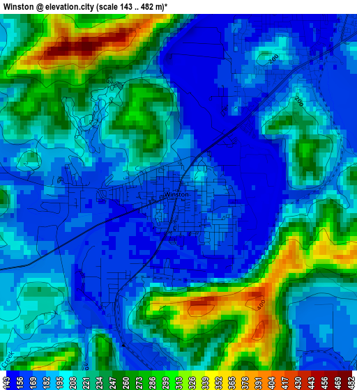
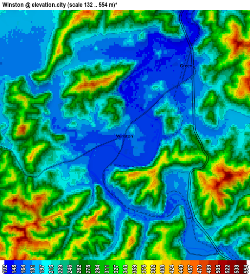
Below is the Elevation map of Winston, which displays elevation range with different colors. Scale of the first map is from 143 to 482 m (469 to 1581 ft) with average elevation of 212.4 meters (=697 ft) [note 1]
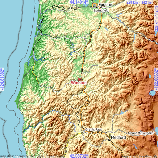
These maps also provides idea of topography and contour of this city, they are displayed at different zoom levels. More info about maps, scale and edge coordinates you can find below images.
| \ | Map #1 | Map #2 | Topo.Map |
| Scale [m] | 143..482 m | 132..554 m | × |
| Scale [ft] | 469..1581 ft | 433..1818 ft | × |
| Average | 212.4 m = 697 ft | 249.3 m = 818 ft | × |
| Width | 7.13 km = 4.4 mi | 14.27 km = 8.9 mi | 228.3 km = 141.9 mi |
| Height | 7.13 km = 4.4 mi | 14.27 km = 8.9 mi | 228.2 km = 141.8 mi |
| ↑Max Latitude | 43.154407° | 43.186457° | 44.14014° |
| Latitude at center | 43.12234° | 43.12234° | 43.12234° |
| ↓Min Latitude | 43.090256° | 43.058155° | 42.08732° |
| ← Min Longitude | -123.456515° | -123.500461° | -124.81882° |
| Longitude center | -123.41257° | -123.41257° | -123.41257° |
| →Max Longitude | -123.368625° | -123.324679° | -122.00632° |
Nearby cities:
Cities around Winston sort by population:
• Roseburg elevation 146 m
11.9 km,  28°
28°
• Sutherlin 156 m
30.9 km,  15°
15°
• Green 154 m
5.6 km,  40°
40°
• Roseburg North 320 m
18.1 km, 29°
• Tri-City 240 m
17.4 km,  151°
151°
• Myrtle Creek 209 m
14.9 km,  139°
139°
• Myrtle Point 28 m
59.3 km,  263°
263°
• Canyonville 235 m
24.2 km, 153°
• Glide 214 m
32.2 km,  51°
51°
• Riddle 213 m
19.5 km,  168°
168°
• Drain 91 m
60.1 km,  7°
7°
• Yoncalla 114 m
54 km, 11°
Multilingual:
 En español:
Winston elevación 165 m.
 En France:
Winston élévation 165 m.


Sources and notes:
- [note 1] Map square and city borders are not equal. Map elevation data is calculated only from area inside that square.
- [src 1] Elevation data from geonames database provided with same terms of usage.
- [src 2] The elevation map of Winston is generated using elevation data from NASA's 3 arcsec (90m) resolution SRTM data.
- [src 3] Base (background) map © OpenStreetMap contributors tiles are generated by Geofabrik and OpenTopoMap.
Copyright & License:
This Winston Elevation Map is licensed under CC BY-SA. You may reuse any part from this page, if you give a proper credit by linking to this URL:
 More info on terms of use page.