Salem elevation
Salem (Oregon, Marion County), United States elevation is 55 meters and Salem elevation in feet is 180 ft above sea level [src 1]. Salem is a seat of a first-order administrative division (feature code) with elevation that is 224 meters (735 ft) smaller than average city elevation in United States.
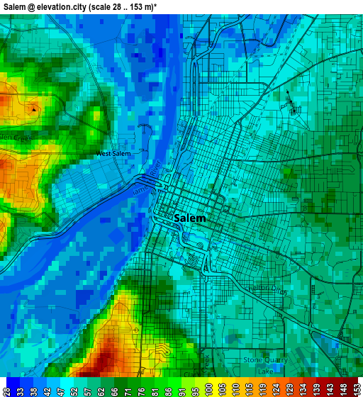
Below is the Elevation map of Salem, which displays elevation range with different colors. Scale of the first map is from 28 to 153 m (92 to 502 ft) with average elevation of 57.8 meters (=190 ft) [note 1]
These maps also provides idea of topography and contour of this city, they are displayed at different zoom levels. More info about maps, scale and edge coordinates you can find below images.
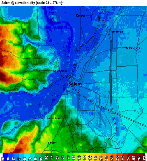
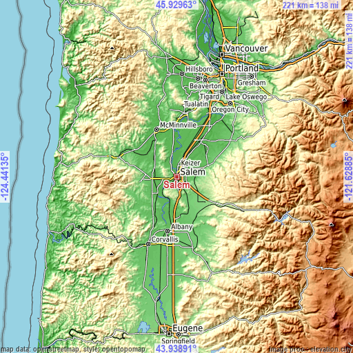
| \ | Map #1 | Map #2 | Topo.Map |
| Scale [m] | 28..153 m | 28..278 m | × |
| Scale [ft] | 92..502 ft | 92..912 ft | × |
| Average | 57.8 m = 190 ft | 79.9 m = 262 ft | × |
| Width | 6.92 km = 4.3 mi | 13.83 km = 8.6 mi | 221.3 km = 137.5 mi |
| Height | 6.92 km = 4.3 mi | 13.83 km = 8.6 mi | 221.3 km = 137.5 mi |
| ↑Max Latitude | 44.973997° | 45.005076° | 45.92963° |
| Latitude at center | 44.9429° | 44.9429° | 44.9429° |
| ↓Min Latitude | 44.911787° | 44.880656° | 43.93891° |
| ← Min Longitude | -123.079045° | -123.122991° | -124.44135° |
| Longitude center | -123.0351° | -123.0351° | -123.0351° |
| →Max Longitude | -122.991155° | -122.947209° | -121.62885° |
Nearby cities:
Cities around Salem sort by population:
• Keizer elevation 42 m
5.3 km,  7°
7°
• Hayesville 55 m
6.3 km,  40°
40°
• Four Corners 69 m
4.4 km,  112°
112°
• Dallas 101 m
22.3 km,  263°
263°
• Monmouth 63 m
18.9 km,  236°
236°
• Silverton 76 m
21 km,  70°
70°
• Independence 52 m
15.7 km,  229°
229°
• Aumsville 113 m
17.2 km,  131°
131°
• Mount Angel 50 m
23.1 km,  53°
53°
• Sublimity 169 m
22.8 km,  123°
123°
• Gervais 56 m
21.3 km,  30°
30°
• Turner 87 m
12.8 km,  149°
149°
Multilingual:
 En español:
Salem elevación 55 m.
 En France:
Salem élévation 55 m.


Sources and notes:
- [note 1] Map square and city borders are not equal. Map elevation data is calculated only from area inside that square.
- [src 1] Elevation data from geonames database provided with same terms of usage.
- [src 2] The elevation map of Salem is generated using elevation data from NASA's 3 arcsec (90m) resolution SRTM data.
- [src 3] Base (background) map © OpenStreetMap contributors tiles are generated by Geofabrik and OpenTopoMap.
Copyright & License:
This Salem Elevation Map is licensed under CC BY-SA. You may reuse any part from this page, if you give a proper credit by linking to this URL:
 More info on terms of use page.