Molalla elevation
Molalla (Oregon, Clackamas County), United States elevation is 117 meters and Molalla elevation in feet is 384 ft above sea level [src 1]. Molalla is a populated place (feature code) with elevation that is 162 meters (531 ft) smaller than average city elevation in United States.
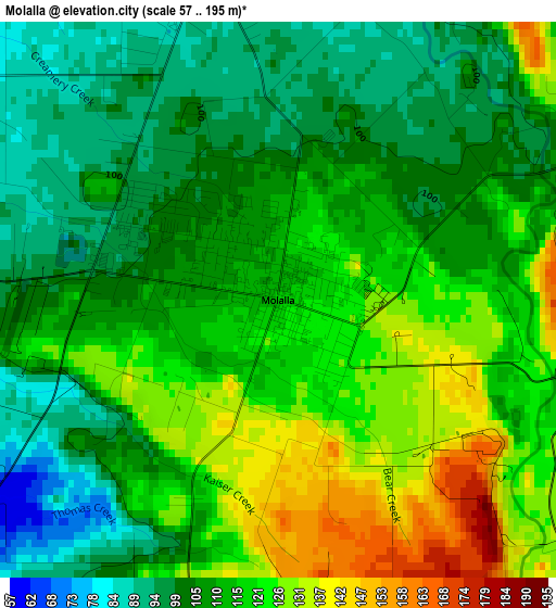
Below is the Elevation map of Molalla, which displays elevation range with different colors. Scale of the first map is from 57 to 195 m (187 to 640 ft) with average elevation of 112.6 meters (=369 ft) [note 1]
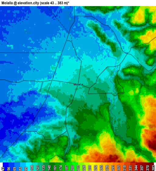
These maps also provides idea of topography and contour of this city, they are displayed at different zoom levels. More info about maps, scale and edge coordinates you can find below images.
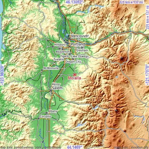
| \ | Map #1 | Map #2 | Topo.Map |
| Scale [m] | 57..195 m | 43..383 m | × |
| Scale [ft] | 187..640 ft | 141..1257 ft | × |
| Average | 112.6 m = 369 ft | 129.5 m = 425 ft | × |
| Width | 6.89 km = 4.3 mi | 13.78 km = 8.6 mi | 220.6 km = 137.1 mi |
| Height | 6.89 km = 4.3 mi | 13.78 km = 8.6 mi | 220.5 km = 137 mi |
| ↑Max Latitude | 45.178326° | 45.209294° | 46.13052° |
| Latitude at center | 45.14734° | 45.14734° | 45.14734° |
| ↓Min Latitude | 45.116338° | 45.085318° | 44.1469° |
| ← Min Longitude | -122.620975° | -122.664921° | -123.98328° |
| Longitude center | -122.57703° | -122.57703° | -122.57703° |
| →Max Longitude | -122.533085° | -122.489139° | -121.17078° |
Nearby cities:
Cities around Molalla sort by population:
• Oregon City elevation 37 m
23.5 km,  354°
354°
• West Linn 44 m
24.4 km, 353°
• Woodburn 59 m
21.8 km,  268°
268°
• Wilsonville 45 m
22.9 km,  317°
317°
• Canby 47 m
15.7 km, 324°
• Silverton 76 m
22.6 km,  225°
225°
• Beavercreek 161 m
16 km,  11°
11°
• Mount Angel 50 m
19.6 km,  243°
243°
• Hubbard 55 m
18.5 km,  282°
282°
• Estacada 158 m
24.8 km,  50°
50°
• Mulino 75 m
8.3 km,  357°
357°
• Donald 59 m
22.2 km,  292°
292°
Multilingual:
 En español:
Molalla elevación 117 m.
 En France:
Molalla élévation 117 m.


Sources and notes:
- [note 1] Map square and city borders are not equal. Map elevation data is calculated only from area inside that square.
- [src 1] Elevation data from geonames database provided with same terms of usage.
- [src 2] The elevation map of Molalla is generated using elevation data from NASA's 3 arcsec (90m) resolution SRTM data.
- [src 3] Base (background) map © OpenStreetMap contributors tiles are generated by Geofabrik and OpenTopoMap.
Copyright & License:
This Molalla Elevation Map is licensed under CC BY-SA. You may reuse any part from this page, if you give a proper credit by linking to this URL:
 More info on terms of use page.