Central Point elevation
Central Point (Oregon, Jackson County), United States elevation is 388 meters and Central Point elevation in feet is 1273 ft above sea level [src 1]. Central Point is a populated place (feature code) with elevation that is 109 meters (358 ft) bigger than average city elevation in United States.
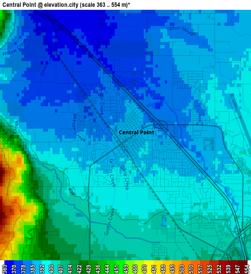
Below is the Elevation map of Central Point, which displays elevation range with different colors. Scale of the first map is from 363 to 554 m (1191 to 1818 ft) with average elevation of 395.6 meters (=1298 ft) [note 1]
These maps also provides idea of topography and contour of this city, they are displayed at different zoom levels. More info about maps, scale and edge coordinates you can find below images.
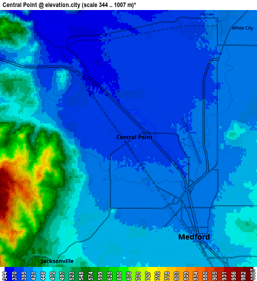
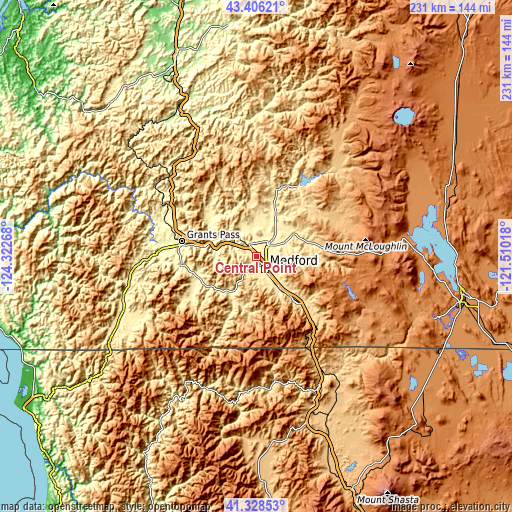
| \ | Map #1 | Map #2 | Topo.Map |
| Scale [m] | 363..554 m | 344..1007 m | × |
| Scale [ft] | 1191..1818 ft | 1129..3304 ft | × |
| Average | 395.6 m = 1298 ft | 442.7 m = 1452 ft | × |
| Width | 7.22 km = 4.5 mi | 14.44 km = 9 mi | 231 km = 143.5 mi |
| Height | 7.22 km = 4.5 mi | 14.44 km = 9 mi | 231 km = 143.5 mi |
| ↑Max Latitude | 42.408416° | 42.440855° | 43.40621° |
| Latitude at center | 42.37596° | 42.37596° | 42.37596° |
| ↓Min Latitude | 42.343488° | 42.310998° | 41.32853° |
| ← Min Longitude | -122.960375° | -123.004321° | -124.32268° |
| Longitude center | -122.91643° | -122.91643° | -122.91643° |
| →Max Longitude | -122.872485° | -122.828539° | -121.51018° |
Nearby cities:
Cities around Central Point sort by population:
• Medford elevation 422 m
6.4 km,  148°
148°
• Ashland 597 m
26.4 km,  139°
139°
• Eagle Point 396 m
14.2 km,  40°
40°
• White City 397 m
8.3 km,  34°
34°
• Talent 497 m
17.9 km, 144°
• Phoenix 460 m
13.8 km, 144°
• Shady Cove 426 m
27.5 km,  18°
18°
• Jacksonville 479 m
8.1 km,  210°
210°
• Rogue River 307 m
22 km,  287°
287°
• Gold Hill 333 m
12.6 km,  299°
299°
• Fruitdale 290 m
32.6 km,  279°
279°
• Williams 426 m
34.2 km,  239°
239°
Multilingual:
 En español:
Central Point elevación 388 m.
 En France:
Central Point élévation 388 m.
 Auf Deutsch:
Central Point höhe über dem Meeresspiegel ist 388 m.

Sources and notes:
- [note 1] Map square and city borders are not equal. Map elevation data is calculated only from area inside that square.
- [src 1] Elevation data from geonames database provided with same terms of usage.
- [src 2] The elevation map of Central Point is generated using elevation data from NASA's 3 arcsec (90m) resolution SRTM data.
- [src 3] Base (background) map © OpenStreetMap contributors tiles are generated by Geofabrik and OpenTopoMap.
Copyright & License:
This Central Point Elevation Map is licensed under CC BY-SA. You may reuse any part from this page, if you give a proper credit by linking to this URL:
 More info on terms of use page.