Bend elevation
Bend (Oregon, Deschutes County), United States elevation is 1106 meters and Bend elevation in feet is 3629 ft above sea level [src 1]. Bend is a seat of a second-order administrative division (feature code) with elevation that is 827 meters (2713 ft) bigger than average city elevation in United States.
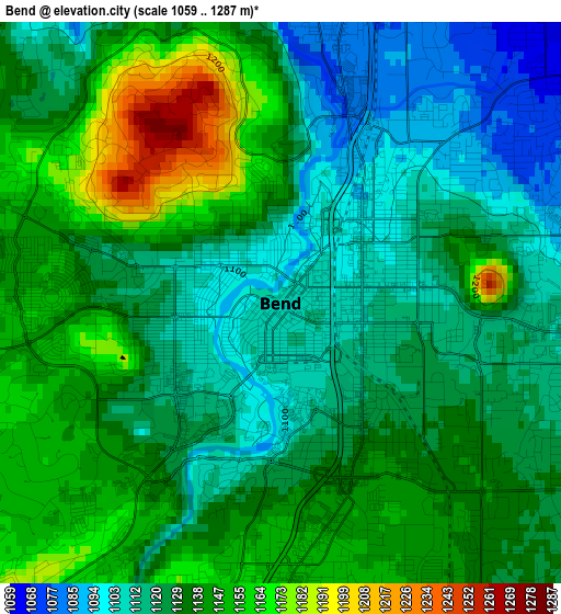
Below is the Elevation map of Bend, which displays elevation range with different colors. Scale of the first map is from 1059 to 1287 m (3474 to 4222 ft) with average elevation of 1131.3 meters (=3712 ft) [note 1]
These maps also provides idea of topography and contour of this city, they are displayed at different zoom levels. More info about maps, scale and edge coordinates you can find below images.
| \ | Map #1 | Map #2 | Topo.Map |
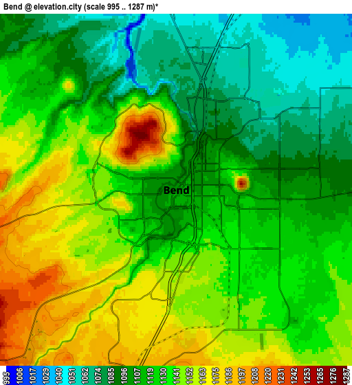
| Scale [m] | 1059..1287 m | 995..1287 m | × |
| Scale [ft] | 3474..4222 ft | 3264..4222 ft | × |
| Average | 1131.3 m = 3712 ft | 1125.6 m = 3693 ft | × |
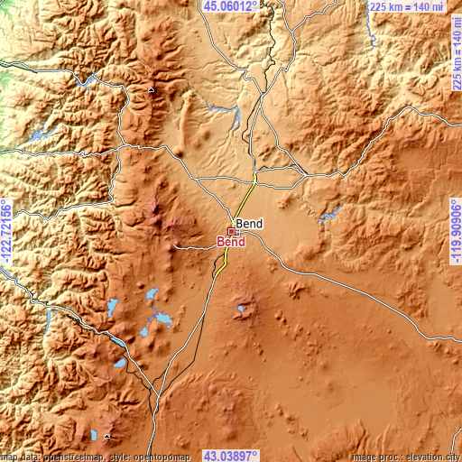
| Width | 7.02 km = 4.4 mi | 14.05 km = 8.7 mi | 224.7 km = 139.6 mi |
| Height | 7.02 km = 4.4 mi | 14.05 km = 8.7 mi | 224.7 km = 139.6 mi |
| ↑Max Latitude | 44.089742° | 44.121298° | 45.06012° |
| Latitude at center | 44.05817° | 44.05817° | 44.05817° |
| ↓Min Latitude | 44.026581° | 43.994975° | 43.03897° |
| ← Min Longitude | -121.359255° | -121.403201° | -122.72156° |
| Longitude center | -121.31531° | -121.31531° | -121.31531° |
| →Max Longitude | -121.271365° | -121.227419° | -119.90906° |
Nearby cities:
Cities around Bend sort by population:
• Redmond elevation 912 m
26.4 km,  25°
25°
• Prineville 878 m
46.8 km,  54°
54°
• Madras 685 m
65.6 km,  13°
13°
• Deschutes River Woods 1198 m
8.2 km,  204°
204°
• Oakridge 368 m
98.2 km,  249°
249°
• Three Rivers 1277 m
29.2 km, 204°
• Warm Springs 466 m
78.5 km,  2°
2°
• Sisters 972 m
31.9 km,  324°
324°
• La Pine 1289 m
45.7 km, 199°
• Culver 802 m
52.6 km, 8°
• Sunriver 1272 m
21.7 km,  207°
207°
• Terrebonne 873 m
34.6 km,  18°
18°
Multilingual:
 En español:
Bend elevación 1106 m.
 En France:
Bend élévation 1106 m.


Sources and notes:
- [note 1] Map square and city borders are not equal. Map elevation data is calculated only from area inside that square.
- [src 1] Elevation data from geonames database provided with same terms of usage.
- [src 2] The elevation map of Bend is generated using elevation data from NASA's 3 arcsec (90m) resolution SRTM data.
- [src 3] Base (background) map © OpenStreetMap contributors tiles are generated by Geofabrik and OpenTopoMap.
Copyright & License:
This Bend Elevation Map is licensed under CC BY-SA. You may reuse any part from this page, if you give a proper credit by linking to this URL:
 More info on terms of use page.