Beaverton elevation
Beaverton (Oregon, Washington County), United States elevation is 55 meters and Beaverton elevation in feet is 180 ft above sea level [src 1]. Beaverton is a populated place (feature code) with elevation that is 224 meters (735 ft) smaller than average city elevation in United States.
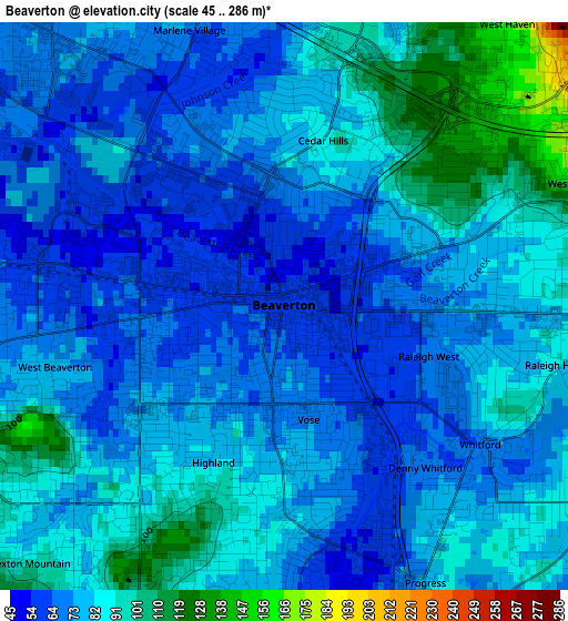
Below is the Elevation map of Beaverton, which displays elevation range with different colors. Scale of the first map is from 45 to 286 m (148 to 938 ft) with average elevation of 78.7 meters (=258 ft) [note 1]
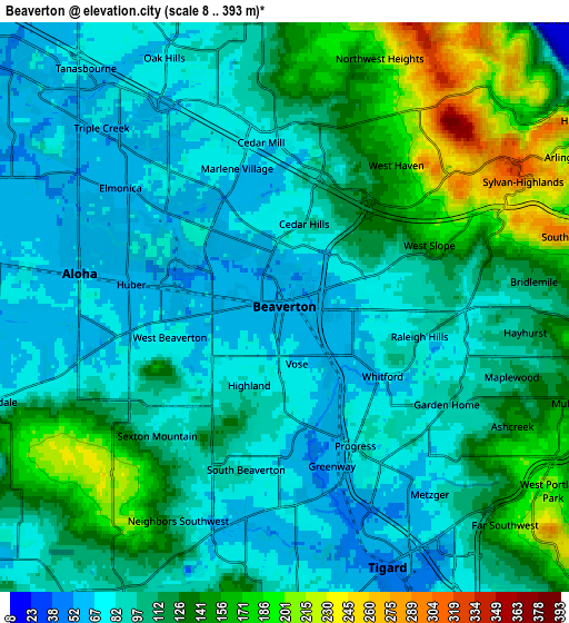
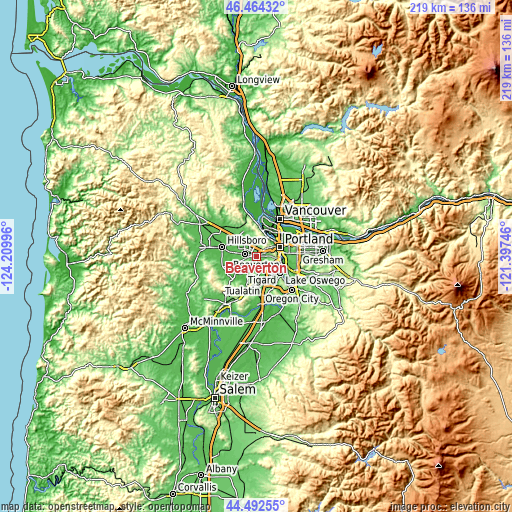
These maps also provides idea of topography and contour of this city, they are displayed at different zoom levels. More info about maps, scale and edge coordinates you can find below images.
| \ | Map #1 | Map #2 | Topo.Map |
| Scale [m] | 45..286 m | 8..393 m | × |
| Scale [ft] | 148..938 ft | 26..1289 ft | × |
| Average | 78.7 m = 258 ft | 109.4 m = 359 ft | × |
| Width | 6.85 km = 4.3 mi | 13.7 km = 8.5 mi | 219.2 km = 136.2 mi |
| Height | 6.85 km = 4.3 mi | 13.7 km = 8.5 mi | 219.2 km = 136.2 mi |
| ↑Max Latitude | 45.51786° | 45.548644° | 46.46432° |
| Latitude at center | 45.48706° | 45.48706° | 45.48706° |
| ↓Min Latitude | 45.456243° | 45.425409° | 44.49255° |
| ← Min Longitude | -122.847655° | -122.891601° | -124.20996° |
| Longitude center | -122.80371° | -122.80371° | -122.80371° |
| →Max Longitude | -122.759765° | -122.715819° | -121.39746° |
Nearby cities:
Cities around Beaverton sort by population:
• Tigard elevation 49 m
6.7 km,  157°
157°
• Aloha 64 m
5 km,  279°
279°
• Cedar Mill 83 m
4.2 km,  352°
352°
• Oak Hills 72 m
6.7 km,  334°
334°
• Rockcreek 56 m
9 km,  320°
320°
• Cedar Hills 85 m
2 km,  11°
11°
• West Haven-Sylvan 163 m
4.3 km,  40°
40°
• Garden Home-Whitford 81 m
4.3 km,  126°
126°
• West Slope 113 m
3.3 km,  66°
66°
• West Haven 164 m
4.3 km, 38°
• Raleigh Hills 92 m
3.3 km,  102°
102°
• Metzger 70 m
5.7 km,  142°
142°
Multilingual:
 En español:
Beaverton elevación 55 m.
 En France:
Beaverton élévation 55 m.
 Auf Deutsch:
Beaverton höhe über dem Meeresspiegel ist 55 m.

Sources and notes:
- [note 1] Map square and city borders are not equal. Map elevation data is calculated only from area inside that square.
- [src 1] Elevation data from geonames database provided with same terms of usage.
- [src 2] The elevation map of Beaverton is generated using elevation data from NASA's 3 arcsec (90m) resolution SRTM data.
- [src 3] Base (background) map © OpenStreetMap contributors tiles are generated by Geofabrik and OpenTopoMap.
Copyright & License:
This Beaverton Elevation Map is licensed under CC BY-SA. You may reuse any part from this page, if you give a proper credit by linking to this URL:
 More info on terms of use page.