Minot elevation
Minot (North Dakota, Ward County), United States elevation is 491 meters and Minot elevation in feet is 1611 ft above sea level [src 1]. Minot is a seat of a second-order administrative division (feature code) with elevation that is 212 meters (696 ft) bigger than average city elevation in United States.
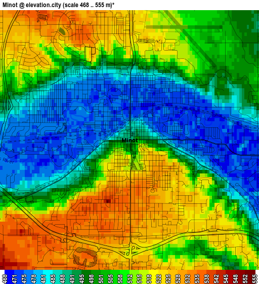
Below is the Elevation map of Minot, which displays elevation range with different colors. Scale of the first map is from 468 to 555 m (1535 to 1821 ft) with average elevation of 504 meters (=1654 ft) [note 1]
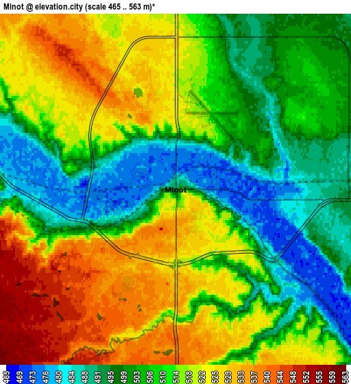
These maps also provides idea of topography and contour of this city, they are displayed at different zoom levels. More info about maps, scale and edge coordinates you can find below images.
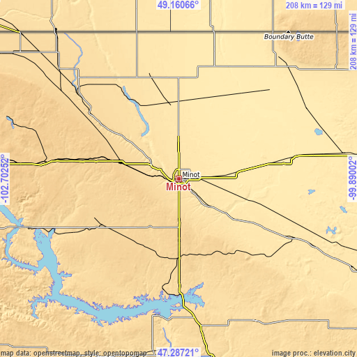
| \ | Map #1 | Map #2 | Topo.Map |
| Scale [m] | 468..555 m | 465..563 m | × |
| Scale [ft] | 1535..1821 ft | 1526..1847 ft | × |
| Average | 504 m = 1654 ft | 511 m = 1677 ft | × |
| Width | 6.51 km = 4 mi | 13.02 km = 8.1 mi | 208.3 km = 129.4 mi |
| Height | 6.51 km = 4 mi | 13.02 km = 8.1 mi | 208.3 km = 129.4 mi |
| ↑Max Latitude | 48.261774° | 48.291021° | 49.16066° |
| Latitude at center | 48.23251° | 48.23251° | 48.23251° |
| ↓Min Latitude | 48.203229° | 48.173932° | 47.28721° |
| ← Min Longitude | -101.340215° | -101.384161° | -102.70252° |
| Longitude center | -101.29627° | -101.29627° | -101.29627° |
| →Max Longitude | -101.252325° | -101.208379° | -99.89002° |
Nearby cities:
Cities around Minot sort by population:
• Minot Air Force Base elevation 491 m
21.2 km,  351°
351°
• Stanley 685 m
81.5 km,  276°
276°
• New Town 583 m
93 km,  252°
252°
• Bottineau 498 m
91.1 km,  43°
43°
• Garrison 589 m
65.1 km,  187°
187°
• Surrey 499 m
12.1 km,  87°
87°
• Parshall 589 m
69.6 km,  243°
243°
• Velva 464 m
33.6 km,  125°
125°
• Burlington 489 m
10.9 km,  295°
295°
• Kenmare 577 m
76 km,  310°
310°
• Mohall 501 m
61.2 km,  344°
344°
• Towner 450 m
67.1 km,  79°
79°
Multilingual:
 En español:
Minot elevación 491 m.
 En France:
Minot élévation 491 m.


Sources and notes:
- [note 1] Map square and city borders are not equal. Map elevation data is calculated only from area inside that square.
- [src 1] Elevation data from geonames database provided with same terms of usage.
- [src 2] The elevation map of Minot is generated using elevation data from NASA's 3 arcsec (90m) resolution SRTM data.
- [src 3] Base (background) map © OpenStreetMap contributors tiles are generated by Geofabrik and OpenTopoMap.
Copyright & License:
This Minot Elevation Map is licensed under CC BY-SA. You may reuse any part from this page, if you give a proper credit by linking to this URL:
 More info on terms of use page.