McClusky elevation
McClusky (North Dakota, Sheridan County), United States elevation is 587 meters and McClusky elevation in feet is 1926 ft above sea level [src 1]. McClusky is a seat of a second-order administrative division (feature code) with elevation that is 308 meters (1010 ft) bigger than average city elevation in United States.
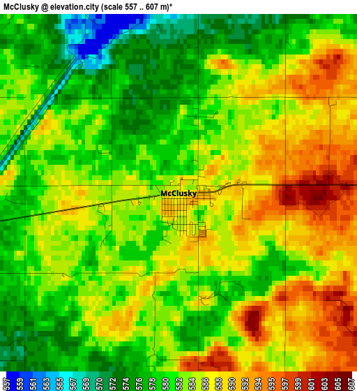
Below is the Elevation map of McClusky, which displays elevation range with different colors. Scale of the first map is from 557 to 607 m (1827 to 1991 ft) with average elevation of 583.3 meters (=1914 ft) [note 1]
These maps also provides idea of topography and contour of this city, they are displayed at different zoom levels. More info about maps, scale and edge coordinates you can find below images.
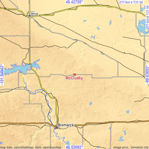
| \ | Map #1 | Topo.Map |
| Scale [m] | 557..607 m | × |
| Scale [ft] | 1827..1991 ft | × |
| Average | 583.3 m = 1914 ft | × |
| Width | 6.6 km = 4.1 mi | 211.3 km = 131.3 mi |
| Height | 6.6 km = 4.1 mi | 211.3 km = 131.3 mi |
| ↑Max Latitude | 47.515519° | 48.42755° |
| Latitude at center | 47.48583° | 47.48583° |
| ↓Min Latitude | 47.456125° | 46.52692° |
| ← Min Longitude | -100.487125° | -101.84943° |
| Longitude center | -100.44318° | -100.44318° |
| →Max Longitude | -100.399235° | -99.03693° |
Nearby cities:
Cities around McClusky sort by population:
• Bismarck elevation 520 m
79.6 km,  198°
198°
• Mandan 505 m
80.7 km, 204°
• Lincoln 514 m
82.7 km,  193°
193°
• Hazen 530 m
91.3 km,  256°
256°
• Harvey 487 m
49.4 km,  50°
50°
• Garrison 589 m
75.3 km,  284°
284°
• Washburn 534 m
49.2 km,  243°
243°
• Velva 464 m
73.1 km,  330°
330°
• Steele 565 m
80.7 km,  150°
150°
• Center 603 m
76.5 km, 237°
• Fessenden 490 m
63.7 km,  73°
73°
• Stanton 521 m
73 km, 255°
Multilingual:
 En español:
McClusky elevación 587 m.
 En France:
McClusky élévation 587 m.
 Auf Deutsch:
McClusky höhe über dem Meeresspiegel ist 587 m.

Sources and notes:
- [note 1] Map square and city borders are not equal. Map elevation data is calculated only from area inside that square.
- [src 1] Elevation data from geonames database provided with same terms of usage.
- [src 2] The elevation map of McClusky is generated using elevation data from NASA's 3 arcsec (90m) resolution SRTM data.
- [src 3] Base (background) map © OpenStreetMap contributors tiles are generated by Geofabrik and OpenTopoMap.
Copyright & License:
This McClusky Elevation Map is licensed under CC BY-SA. You may reuse any part from this page, if you give a proper credit by linking to this URL:
 More info on terms of use page.