Choteau elevation
Choteau (Montana, Teton County), United States elevation is 1165 meters and Choteau elevation in feet is 3822 ft above sea level [src 1]. Choteau is a seat of a second-order administrative division (feature code) with elevation that is 886 meters (2907 ft) bigger than average city elevation in United States.
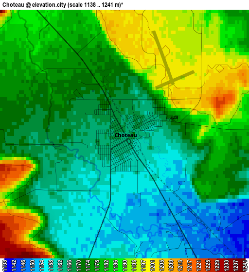
Below is the Elevation map of Choteau, which displays elevation range with different colors. Scale of the first map is from 1138 to 1241 m (3734 to 4072 ft) with average elevation of 1174.6 meters (=3854 ft) [note 1]
These maps also provides idea of topography and contour of this city, they are displayed at different zoom levels. More info about maps, scale and edge coordinates you can find below images.
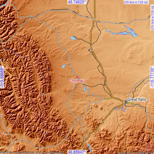
| \ | Map #1 | Topo.Map |
| Scale [m] | 1138..1241 m | × |
| Scale [ft] | 3734..4072 ft | × |
| Average | 1174.6 m = 3854 ft | × |
| Width | 6.56 km = 4.1 mi | 210 km = 130.5 mi |
| Height | 6.56 km = 4.1 mi | 210 km = 130.5 mi |
| ↑Max Latitude | 47.841954° | 48.74825° |
| Latitude at center | 47.81245° | 47.81245° |
| ↓Min Latitude | 47.78293° | 46.85947° |
| ← Min Longitude | -112.227575° | -113.58988° |
| Longitude center | -112.18363° | -112.18363° |
| →Max Longitude | -112.139685° | -110.77738° |
Nearby cities:
Cities around Choteau sort by population:
• Great Falls elevation 1014 m
74.7 km,  117°
117°
• Malmstrom Air Force Base 1056 m
82.3 km,  114°
114°
• Shelby 1005 m
80.8 km,  17°
17°
• Cut Bank 1151 m
91.8 km,  353°
353°
• Conrad 1068 m
43.5 km, 23°
• North Browning 1327 m
104.1 km,  324°
324°
• South Browning 1338 m
102.2 km, 322°
• Sun Prairie 1016 m
60.9 km, 120°
• Fort Benton 803 m
113.2 km,  89°
89°
• Browning 1331 m
103.1 km, 323°
• Lincoln 1384 m
102.5 km,  201°
201°
• Chester 952 m
119 km,  49°
49°
Multilingual:
 En español:
Choteau elevación 1165 m.
 En France:
Choteau élévation 1165 m.
 Auf Deutsch:
Choteau höhe über dem Meeresspiegel ist 1165 m.

Sources and notes:
- [note 1] Map square and city borders are not equal. Map elevation data is calculated only from area inside that square.
- [src 1] Elevation data from geonames database provided with same terms of usage.
- [src 2] The elevation map of Choteau is generated using elevation data from NASA's 3 arcsec (90m) resolution SRTM data.
- [src 3] Base (background) map © OpenStreetMap contributors tiles are generated by Geofabrik and OpenTopoMap.
Copyright & License:
This Choteau Elevation Map is licensed under CC BY-SA. You may reuse any part from this page, if you give a proper credit by linking to this URL:
 More info on terms of use page.