Fort Lupton elevation
Fort Lupton (Colorado, Weld County), United States elevation is 1499 meters and Fort Lupton elevation in feet is 4918 ft above sea level [src 1]. Fort Lupton is a populated place (feature code) with elevation that is 1220 meters (4003 ft) bigger than average city elevation in United States.
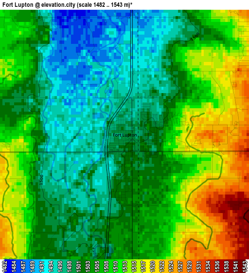
Below is the Elevation map of Fort Lupton, which displays elevation range with different colors. Scale of the first map is from 1482 to 1543 m (4862 to 5062 ft) with average elevation of 1505.5 meters (=4939 ft) [note 1]
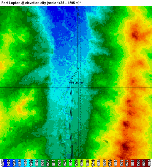
These maps also provides idea of topography and contour of this city, they are displayed at different zoom levels. More info about maps, scale and edge coordinates you can find below images.
| \ | Map #1 | Map #2 | Topo.Map |
| Scale [m] | 1482..1543 m | 1475..1595 m | × |
| Scale [ft] | 4862..5062 ft | 4839..5233 ft | × |
| Average | 1505.5 m = 4939 ft | 1522.1 m = 4994 ft | × |
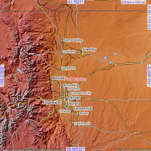
| Width | 7.48 km = 4.6 mi | 14.95 km = 9.3 mi | 239.3 km = 148.7 mi |
| Height | 7.48 km = 4.6 mi | 14.95 km = 9.3 mi | 239.3 km = 148.7 mi |
| ↑Max Latitude | 40.118324° | 40.151921° | 41.1521° |
| Latitude at center | 40.08471° | 40.08471° | 40.08471° |
| ↓Min Latitude | 40.051079° | 40.017432° | 39.00032° |
| ← Min Longitude | -104.856975° | -104.900921° | -106.21928° |
| Longitude center | -104.81303° | -104.81303° | -104.81303° |
| →Max Longitude | -104.769085° | -104.725139° | -103.40678° |
Nearby cities:
Cities around Fort Lupton sort by population:
• Brighton elevation 1520 m
11.1 km,  183°
183°
• Erie 1539 m
20.5 km,  259°
259°
• Firestone 1516 m
11 km,  286°
286°
• Frederick 1521 m
10.7 km,  278°
278°
• Lochbuie 1533 m
11.9 km,  136°
136°
• Dacono 1533 m
10.8 km,  270°
270°
• Mead 1528 m
22.8 km,  316°
316°
• Todd Creek 1540 m
12.9 km,  203°
203°
• Platteville 1472 m
14.5 km,  356°
356°
• Hudson 1528 m
14.5 km,  94°
94°
• Aristocrat Ranchettes 1528 m
5.1 km,  57°
57°
• Gilcrest 1450 m
22.1 km,  7°
7°
Multilingual:
 En español:
Fort Lupton elevación 1499 m.
 En France:
Fort Lupton élévation 1499 m.
 Auf Deutsch:
Fort Lupton höhe über dem Meeresspiegel ist 1499 m.

Sources and notes:
- [note 1] Map square and city borders are not equal. Map elevation data is calculated only from area inside that square.
- [src 1] Elevation data from geonames database provided with same terms of usage.
- [src 2] The elevation map of Fort Lupton is generated using elevation data from NASA's 3 arcsec (90m) resolution SRTM data.
- [src 3] Base (background) map © OpenStreetMap contributors tiles are generated by Geofabrik and OpenTopoMap.
Copyright & License:
This Fort Lupton Elevation Map is licensed under CC BY-SA. You may reuse any part from this page, if you give a proper credit by linking to this URL:
 More info on terms of use page.