Bayside elevation
Bayside (California, Humboldt County), United States elevation is 10 meters and Bayside elevation in feet is 33 ft above sea level [src 1]. Bayside is a populated place (feature code) with elevation that is 269 meters (883 ft) smaller than average city elevation in United States.
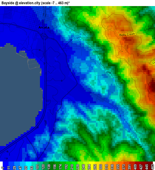
Below is the Elevation map of Bayside, which displays elevation range with different colors. Scale of the first map is from -7 to 463 m (-23 to 1519 ft) with average elevation of 116.8 meters (=383 ft) [note 1]
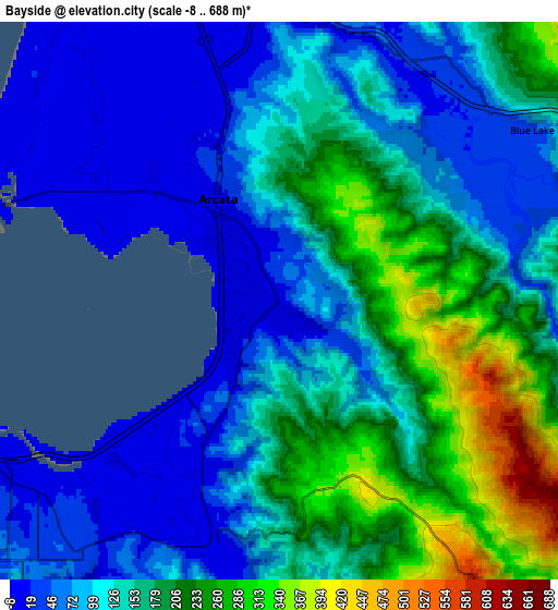
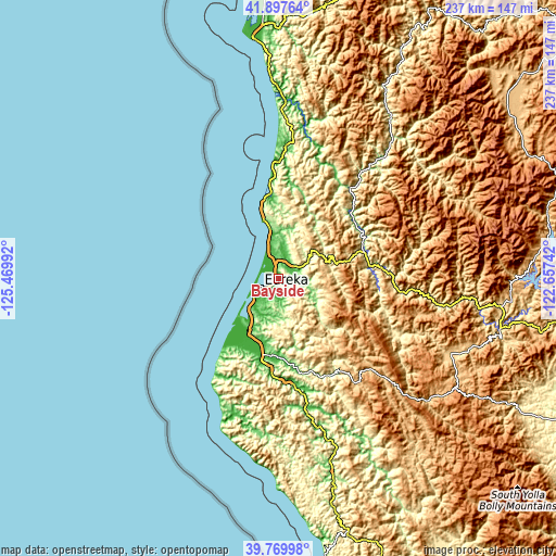
These maps also provides idea of topography and contour of this city, they are displayed at different zoom levels. More info about maps, scale and edge coordinates you can find below images.
| \ | Map #1 | Map #2 | Topo.Map |
| Scale [m] | -7..463 m | -8..688 m | × |
| Scale [ft] | -23..1519 ft | -26..2257 ft | × |
| Average | 116.8 m = 383 ft | 135.2 m = 444 ft | × |
| Width | 7.39 km = 4.6 mi | 14.79 km = 9.2 mi | 236.6 km = 147 mi |
| Height | 7.39 km = 4.6 mi | 14.79 km = 9.2 mi | 236.6 km = 147 mi |
| ↑Max Latitude | 40.875587° | 40.908807° | 41.89764° |
| Latitude at center | 40.84235° | 40.84235° | 40.84235° |
| ↓Min Latitude | 40.809097° | 40.775826° | 39.76998° |
| ← Min Longitude | -124.107615° | -124.151561° | -125.46992° |
| Longitude center | -124.06367° | -124.06367° | -124.06367° |
| →Max Longitude | -124.019725° | -123.975779° | -122.65742° |
Nearby cities:
Cities around Bayside sort by population:
• Eureka elevation 15 m
9.5 km,  241°
241°
• Arcata 8 m
3.1 km,  329°
329°
• McKinleyville 44 m
12 km,  344°
344°
• Fortuna 20 m
28.3 km,  196°
196°
• Myrtletown 33 m
8.2 km,  223°
223°
• Humboldt Hill 91 m
16.7 km, 219°
• Pine Hills 130 m
14.2 km,  211°
211°
• Cutten 60 m
10.5 km, 219°
• Bayview 18 m
12.8 km,  232°
232°
• Blue Lake 42 m
8.1 km,  56°
56°
• Hydesville 113 m
32.9 km,  184°
184°
• Westhaven-Moonstone 155 m
22.8 km,  351°
351°
Multilingual:
 En español:
Bayside elevación 10 m.
 En France:
Bayside élévation 10 m.


Sources and notes:
- [note 1] Map square and city borders are not equal. Map elevation data is calculated only from area inside that square.
- [src 1] Elevation data from geonames database provided with same terms of usage.
- [src 2] The elevation map of Bayside is generated using elevation data from NASA's 3 arcsec (90m) resolution SRTM data.
- [src 3] Base (background) map © OpenStreetMap contributors tiles are generated by Geofabrik and OpenTopoMap.
Copyright & License:
This Bayside Elevation Map is licensed under CC BY-SA. You may reuse any part from this page, if you give a proper credit by linking to this URL:
 More info on terms of use page.