Wellington elevation
Wellington (Utah, Carbon County), United States elevation is 1653 meters and Wellington elevation in feet is 5423 ft above sea level [src 1]. Wellington is a populated place (feature code) with elevation that is 1374 meters (4508 ft) bigger than average city elevation in United States.
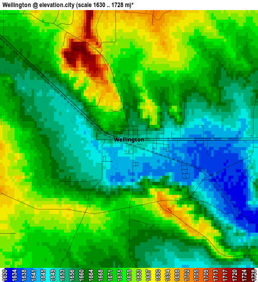
Below is the Elevation map of Wellington, which displays elevation range with different colors. Scale of the first map is from 1630 to 1728 m (5348 to 5669 ft) with average elevation of 1667.5 meters (=5471 ft) [note 1]
These maps also provides idea of topography and contour of this city, they are displayed at different zoom levels. More info about maps, scale and edge coordinates you can find below images.
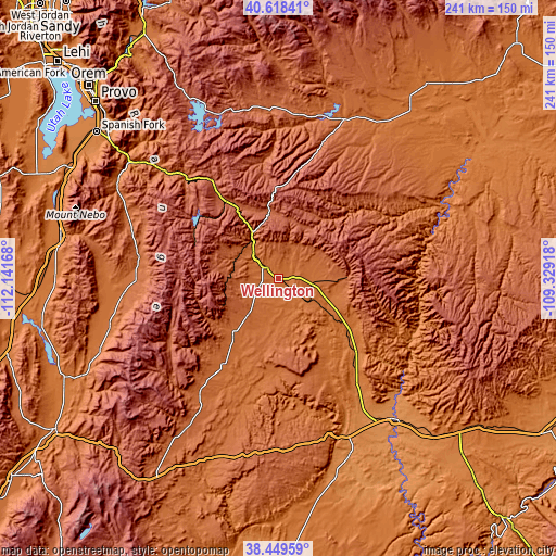
| \ | Map #1 | Topo.Map |
| Scale [m] | 1630..1728 m | × |
| Scale [ft] | 5348..5669 ft | × |
| Average | 1667.5 m = 5471 ft | × |
| Width | 7.54 km = 4.7 mi | 241.2 km = 149.9 mi |
| Height | 7.54 km = 4.7 mi | 241.1 km = 149.8 mi |
| ↑Max Latitude | 39.57635° | 40.61841° |
| Latitude at center | 39.54247° | 39.54247° |
| ↓Min Latitude | 39.508573° | 38.44959° |
| ← Min Longitude | -110.779375° | -112.14168° |
| Longitude center | -110.73543° | -110.73543° |
| →Max Longitude | -110.691485° | -109.32918° |
Nearby cities:
Cities around Wellington sort by population:
• Price elevation 1699 m
9 km,  314°
314°
• Mount Pleasant 1809 m
61.7 km,  270°
270°
• Helper 1778 m
18.8 km,  327°
327°
• Huntington 1769 m
31 km,  219°
219°
• Carbonville 1712 m
12.1 km,  315°
315°
• Ferron 1822 m
60.5 km,  214°
214°
• Castle Dale 1731 m
44.1 km, 213°
• Orangeville 1764 m
44.5 km, 217°
• East Carbon City 1926 m
27.5 km,  88°
88°
• Fairview 1816 m
61.1 km,  278°
278°
• Spring Glen 1762 m
16.5 km, 322°
• Spring City 1778 m
65.6 km,  264°
264°
Multilingual:
 En español:
Wellington elevación 1653 m.
 En France:
Wellington élévation 1653 m.
 Auf Deutsch:
Wellington höhe über dem Meeresspiegel ist 1653 m.

Sources and notes:
- [note 1] Map square and city borders are not equal. Map elevation data is calculated only from area inside that square.
- [src 1] Elevation data from geonames database provided with same terms of usage.
- [src 2] The elevation map of Wellington is generated using elevation data from NASA's 3 arcsec (90m) resolution SRTM data.
- [src 3] Base (background) map © OpenStreetMap contributors tiles are generated by Geofabrik and OpenTopoMap.
Copyright & License:
This Wellington Elevation Map is licensed under CC BY-SA. You may reuse any part from this page, if you give a proper credit by linking to this URL:
 More info on terms of use page.