El Paso elevation
El Paso (Texas, El Paso County), United States elevation is 1137 meters and El Paso elevation in feet is 3730 ft above sea level [src 1]. El Paso is a seat of a second-order administrative division (feature code) with elevation that is 858 meters (2815 ft) bigger than average city elevation in United States.
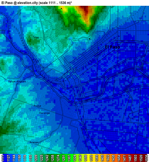
Below is the Elevation map of El Paso, which displays elevation range with different colors. Scale of the first map is from 1111 to 1536 m (3645 to 5039 ft) with average elevation of 1159.5 meters (=3804 ft) [note 1]
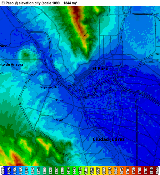
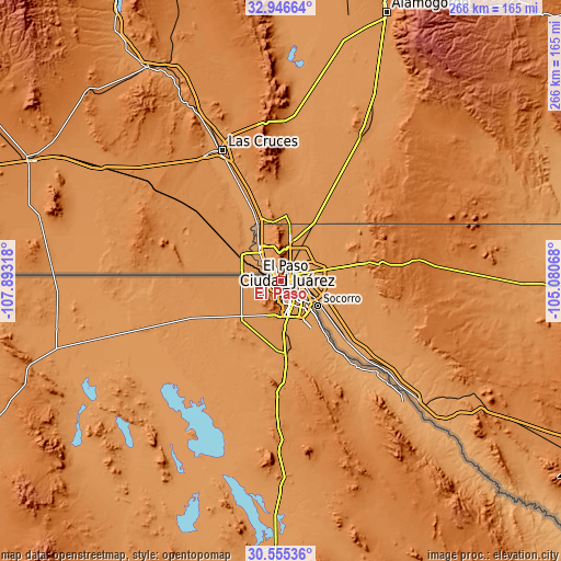
These maps also provides idea of topography and contour of this city, they are displayed at different zoom levels. More info about maps, scale and edge coordinates you can find below images.
| \ | Map #1 | Map #2 | Topo.Map |
| Scale [m] | 1111..1536 m | 1099..1844 m | × |
| Scale [ft] | 3645..5039 ft | 3606..6050 ft | × |
| Average | 1159.5 m = 3804 ft | 1209.2 m = 3967 ft | × |
| Width | 8.31 km = 5.2 mi | 16.62 km = 10.3 mi | 265.9 km = 165.2 mi |
| Height | 8.31 km = 5.2 mi | 16.62 km = 10.3 mi | 265.9 km = 165.2 mi |
| ↑Max Latitude | 31.796078° | 31.833421° | 32.94664° |
| Latitude at center | 31.75872° | 31.75872° | 31.75872° |
| ↓Min Latitude | 31.721347° | 31.683959° | 30.55536° |
| ← Min Longitude | -106.530875° | -106.574821° | -107.89318° |
| Longitude center | -106.48693° | -106.48693° | -106.48693° |
| →Max Longitude | -106.442985° | -106.399039° | -105.08068° |
Nearby cities:
Cities around El Paso sort by population:
• Socorro elevation 1112 m
20.9 km,  123°
123°
• Socorro Mission Number 1 Colonia 1109 m
23 km,  126°
126°
• Horizon City 1228 m
27.4 km,  105°
105°
• Sunland Park 1156 m
9.7 km,  295°
295°
• San Elizario 1107 m
28 km, 133°
• Fort Bliss 1184 m
9.3 km,  49°
49°
• Canutillo 1144 m
20.1 km,  327°
327°
• Sparks 1159 m
25.3 km, 112°
• Santa Teresa 1152 m
18 km,  306°
306°
• Westway 1200 m
23.8 km,  338°
338°
• Vinton 1152 m
24 km, 332°
• La Union 1153 m
27 km,  322°
322°
Multilingual:
 En español:
El Paso elevación 1137 m.
 En France:
El Paso élévation 1137 m.
 Auf Deutsch:
El Paso höhe über dem Meeresspiegel ist 1137 m.

Sources and notes:
- [note 1] Map square and city borders are not equal. Map elevation data is calculated only from area inside that square.
- [src 1] Elevation data from geonames database provided with same terms of usage.
- [src 2] The elevation map of El Paso is generated using elevation data from NASA's 3 arcsec (90m) resolution SRTM data.
- [src 3] Base (background) map © OpenStreetMap contributors tiles are generated by Geofabrik and OpenTopoMap.
Copyright & License:
This El Paso Elevation Map is licensed under CC BY-SA. You may reuse any part from this page, if you give a proper credit by linking to this URL:
 More info on terms of use page.