Del Rio elevation
Del Rio (Texas, Val Verde County), United States elevation is 296 meters and Del Rio elevation in feet is 971 ft above sea level [src 1]. Del Rio is a seat of a second-order administrative division (feature code) with elevation that is 17 meters (56 ft) bigger than average city elevation in United States.
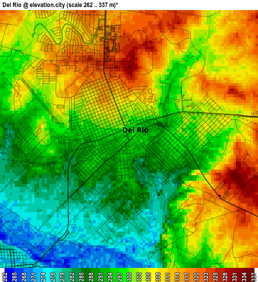
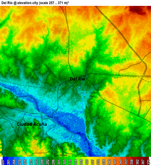
Below is the Elevation map of Del Rio, which displays elevation range with different colors. Scale of the first map is from 262 to 337 m (860 to 1106 ft) with average elevation of 299.6 meters (=983 ft) [note 1]
These maps also provides idea of topography and contour of this city, they are displayed at different zoom levels. More info about maps, scale and edge coordinates you can find below images.
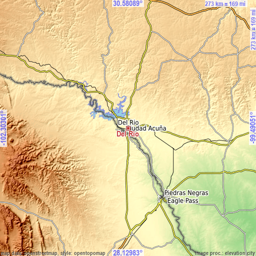
| \ | Map #1 | Map #2 | Topo.Map |
| Scale [m] | 262..337 m | 257..371 m | × |
| Scale [ft] | 860..1106 ft | 843..1217 ft | × |
| Average | 299.6 m = 983 ft | 308.2 m = 1011 ft | × |
| Width | 8.52 km = 5.3 mi | 17.03 km = 10.6 mi | 272.5 km = 169.3 mi |
| Height | 8.52 km = 5.3 mi | 17.03 km = 10.6 mi | 272.5 km = 169.3 mi |
| ↑Max Latitude | 29.401023° | 29.439301° | 30.58089° |
| Latitude at center | 29.36273° | 29.36273° | 29.36273° |
| ↓Min Latitude | 29.324423° | 29.286102° | 28.12983° |
| ← Min Longitude | -100.940705° | -100.984651° | -102.30301° |
| Longitude center | -100.89676° | -100.89676° | -100.89676° |
| →Max Longitude | -100.852815° | -100.808869° | -99.49051° |
Nearby cities:
Cities around Del Rio sort by population:
• Eagle Pass elevation 226 m
82.3 km,  152°
152°
• Eidson Road 227 m
86 km, 152°
• Rosita North 240 m
91.1 km, 149°
• Cienegas Terrace 292 m
4.6 km,  276°
276°
• Las Quintas Fronterizas 229 m
85.5 km, 150°
• Las Quintas Fronterizas Colonia 228 m
85.4 km, 150°
• Elm Creek 229 m
76.3 km, 148°
• Val Verde Park 329 m
6.4 km,  77°
77°
• Siesta Acres 234 m
78 km, 149°
• Brackettville 340 m
46.8 km,  97°
97°
• Laughlin Air Force Base 330 m
11 km,  93°
93°
• Fort Clark Springs 352 m
46.4 km, 97°
Multilingual:
 En español:
Del Río elevación 296 m.
 En France:
Del Rio élévation 296 m.


Sources and notes:
- [note 1] Map square and city borders are not equal. Map elevation data is calculated only from area inside that square.
- [src 1] Elevation data from geonames database provided with same terms of usage.
- [src 2] The elevation map of Del Rio is generated using elevation data from NASA's 3 arcsec (90m) resolution SRTM data.
- [src 3] Base (background) map © OpenStreetMap contributors tiles are generated by Geofabrik and OpenTopoMap.
Copyright & License:
This Del Rio Elevation Map is licensed under CC BY-SA. You may reuse any part from this page, if you give a proper credit by linking to this URL:
 More info on terms of use page.