Clarendon elevation
Clarendon (Texas, Donley County), United States elevation is 836 meters and Clarendon elevation in feet is 2743 ft above sea level [src 1]. Clarendon is a seat of a second-order administrative division (feature code) with elevation that is 557 meters (1827 ft) bigger than average city elevation in United States.
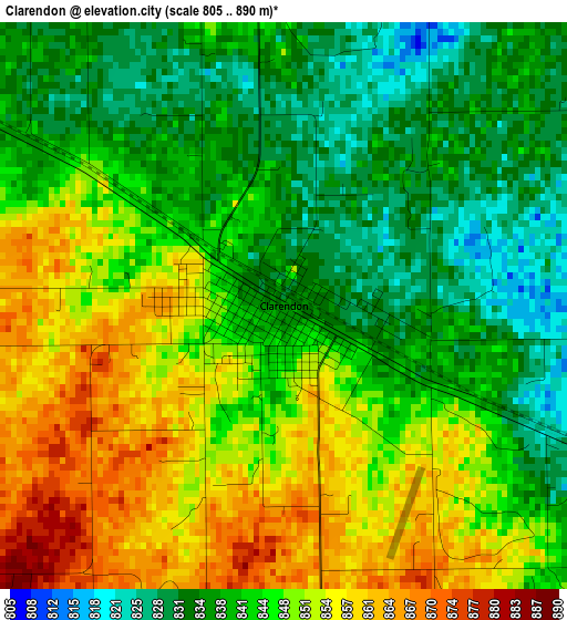
Below is the Elevation map of Clarendon, which displays elevation range with different colors. Scale of the first map is from 805 to 890 m (2641 to 2920 ft) with average elevation of 844.7 meters (=2771 ft) [note 1]
These maps also provides idea of topography and contour of this city, they are displayed at different zoom levels. More info about maps, scale and edge coordinates you can find below images.
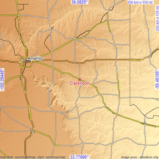
| \ | Map #1 | Topo.Map |
| Scale [m] | 805..890 m | × |
| Scale [ft] | 2641..2920 ft | × |
| Average | 844.7 m = 2771 ft | × |
| Width | 8.01 km = 5 mi | 256.4 km = 159.3 mi |
| Height | 8.01 km = 5 mi | 256.4 km = 159.3 mi |
| ↑Max Latitude | 34.973847° | 36.0825° |
| Latitude at center | 34.93783° | 34.93783° |
| ↓Min Latitude | 34.901797° | 33.77696° |
| ← Min Longitude | -100.932145° | -102.29445° |
| Longitude center | -100.8882° | -100.8882° |
| →Max Longitude | -100.844255° | -99.48195° |
Nearby cities:
Cities around Clarendon sort by population:
• Amarillo elevation 1124 m
91.4 km,  290°
290°
• Pampa 991 m
66.8 km,  354°
354°
• Childress 574 m
84.5 km,  132°
132°
• Tulia 1064 m
91.2 km,  240°
240°
• Panhandle 1057 m
63.7 km,  315°
315°
• Wellington 624 m
62.2 km,  98°
98°
• Memphis 629 m
40.1 km, 126°
• Shamrock 718 m
65.8 km,  62°
62°
• Wheeler 768 m
79.6 km,  44°
44°
• Claude 1039 m
47.4 km, 294°
• Silverton 1002 m
64.1 km,  216°
216°
• Miami 840 m
86.8 km,  15°
15°
Multilingual:
 En español:
Clarendon elevación 836 m.
 En France:
Clarendon élévation 836 m.
 Auf Deutsch:
Clarendon höhe über dem Meeresspiegel ist 836 m.

Sources and notes:
- [note 1] Map square and city borders are not equal. Map elevation data is calculated only from area inside that square.
- [src 1] Elevation data from geonames database provided with same terms of usage.
- [src 2] The elevation map of Clarendon is generated using elevation data from NASA's 3 arcsec (90m) resolution SRTM data.
- [src 3] Base (background) map © OpenStreetMap contributors tiles are generated by Geofabrik and OpenTopoMap.
Copyright & License:
This Clarendon Elevation Map is licensed under CC BY-SA. You may reuse any part from this page, if you give a proper credit by linking to this URL:
 More info on terms of use page.