Navajo elevation
Navajo (New Mexico, McKinley County), United States elevation is 2168 meters and Navajo elevation in feet is 7113 ft above sea level [src 1]. Navajo is a populated place (feature code) with elevation that is 1889 meters (6198 ft) bigger than average city elevation in United States.
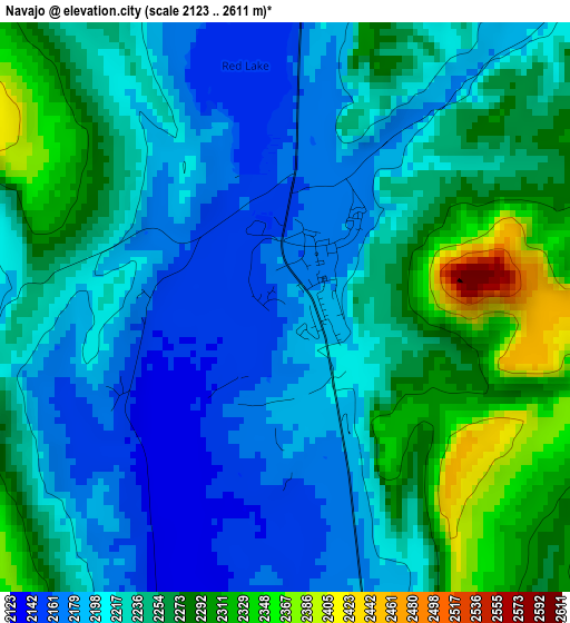
Below is the Elevation map of Navajo, which displays elevation range with different colors. Scale of the first map is from 2123 to 2611 m (6965 to 8566 ft) with average elevation of 2232.2 meters (=7323 ft) [note 1]
These maps also provides idea of topography and contour of this city, they are displayed at different zoom levels. More info about maps, scale and edge coordinates you can find below images.
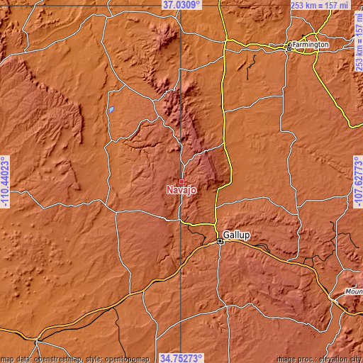
| \ | Map #1 | Topo.Map |
| Scale [m] | 2123..2611 m | × |
| Scale [ft] | 6965..8566 ft | × |
| Average | 2232.2 m = 7323 ft | × |
| Width | 7.92 km = 4.9 mi | 253.3 km = 157.4 mi |
| Height | 7.92 km = 4.9 mi | 253.3 km = 157.4 mi |
| ↑Max Latitude | 35.9356° | 37.0309° |
| Latitude at center | 35.90001° | 35.90001° |
| ↓Min Latitude | 35.864404° | 34.75273° |
| ← Min Longitude | -109.077925° | -110.44023° |
| Longitude center | -109.03398° | -109.03398° |
| →Max Longitude | -108.990035° | -107.62773° |
Nearby cities:
Cities around Navajo sort by population:
• Gallup elevation 1985 m
49 km,  147°
147°
• Chinle 1682 m
54.5 km,  301°
301°
• Fort Defiance 2085 m
17.7 km,  192°
192°
• Window Rock 2105 m
24.5 km,  183°
183°
• Lukachukai 1999 m
60.1 km,  343°
343°
• Saint Michaels 2056 m
28.9 km, 191°
• Many Farms 1619 m
72.7 km,  313°
313°
• Ganado 1949 m
50.4 km,  245°
245°
• Tsaile 2147 m
47.7 km, 339°
• Church Rock 2042 m
56.5 km,  136°
136°
• Twin Lakes 1941 m
31.6 km,  132°
132°
• Houck 1845 m
70.4 km, 192°
Multilingual:
 En español:
Navajo elevación 2168 m.
 En France:
Navajo élévation 2168 m.


Sources and notes:
- [note 1] Map square and city borders are not equal. Map elevation data is calculated only from area inside that square.
- [src 1] Elevation data from geonames database provided with same terms of usage.
- [src 2] The elevation map of Navajo is generated using elevation data from NASA's 3 arcsec (90m) resolution SRTM data.
- [src 3] Base (background) map © OpenStreetMap contributors tiles are generated by Geofabrik and OpenTopoMap.
Copyright & License:
This Navajo Elevation Map is licensed under CC BY-SA. You may reuse any part from this page, if you give a proper credit by linking to this URL:
 More info on terms of use page.