La Luz elevation
La Luz (New Mexico, Otero County), United States elevation is 1444 meters and La Luz elevation in feet is 4738 ft above sea level [src 1]. La Luz is a populated place (feature code) with elevation that is 1165 meters (3822 ft) bigger than average city elevation in United States.
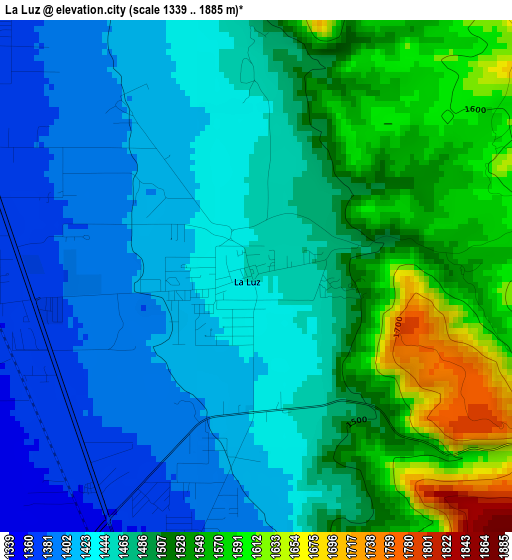
Below is the Elevation map of La Luz, which displays elevation range with different colors. Scale of the first map is from 1339 to 1885 m (4393 to 6184 ft) with average elevation of 1477.7 meters (=4848 ft) [note 1]
These maps also provides idea of topography and contour of this city, they are displayed at different zoom levels. More info about maps, scale and edge coordinates you can find below images.
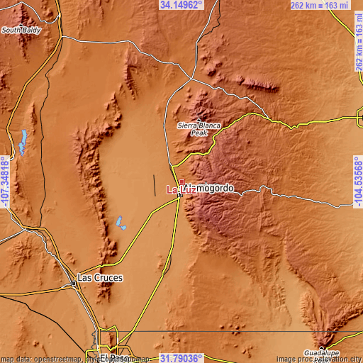
| \ | Map #1 | Topo.Map |
| Scale [m] | 1339..1885 m | × |
| Scale [ft] | 4393..6184 ft | × |
| Average | 1477.7 m = 4848 ft | × |
| Width | 8.2 km = 5.1 mi | 262.3 km = 163 mi |
| Height | 8.2 km = 5.1 mi | 262.3 km = 163 mi |
| ↑Max Latitude | 33.014727° | 34.14962° |
| Latitude at center | 32.97787° | 32.97787° |
| ↓Min Latitude | 32.940997° | 31.79036° |
| ← Min Longitude | -105.985875° | -107.34818° |
| Longitude center | -105.94193° | -105.94193° |
| →Max Longitude | -105.897985° | -104.53568° |
Nearby cities:
Cities around La Luz sort by population:
• Alamogordo elevation 1319 m
8.9 km,  191°
191°
• Ruidoso 2057 m
46.6 km,  32°
32°
• Holloman Air Force Base 1241 m
20.6 km,  225°
225°
• Tularosa 1376 m
12.9 km,  326°
326°
• Ruidoso Downs 1961 m
50.1 km,  38°
38°
• Radium Springs 1208 m
106.4 km,  240°
240°
• White Sands 1294 m
83.3 km,  217°
217°
• Boles Acres 1246 m
19.4 km, 192°
• Capitan 1941 m
71.9 km, 28°
• Mescalero 2014 m
25.4 km, 38°
• Doña Ana 1207 m
104.6 km, 231°
• Carrizozo 1657 m
74.1 km,  4°
4°
Multilingual:
 En español:
La Luz elevación 1444 m.
 En France:
La Luz élévation 1444 m.


Sources and notes:
- [note 1] Map square and city borders are not equal. Map elevation data is calculated only from area inside that square.
- [src 1] Elevation data from geonames database provided with same terms of usage.
- [src 2] The elevation map of La Luz is generated using elevation data from NASA's 3 arcsec (90m) resolution SRTM data.
- [src 3] Base (background) map © OpenStreetMap contributors tiles are generated by Geofabrik and OpenTopoMap.
Copyright & License:
This La Luz Elevation Map is licensed under CC BY-SA. You may reuse any part from this page, if you give a proper credit by linking to this URL:
 More info on terms of use page.