Dexter elevation
Dexter (New Mexico, Chaves County), United States elevation is 1059 meters and Dexter elevation in feet is 3474 ft above sea level [src 1]. Dexter is a populated place (feature code) with elevation that is 780 meters (2559 ft) bigger than average city elevation in United States.
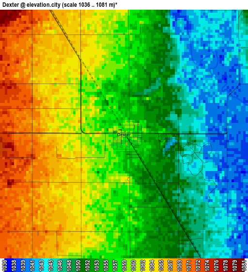
Below is the Elevation map of Dexter, which displays elevation range with different colors. Scale of the first map is from 1036 to 1081 m (3399 to 3547 ft) with average elevation of 1056.2 meters (=3465 ft) [note 1]
These maps also provides idea of topography and contour of this city, they are displayed at different zoom levels. More info about maps, scale and edge coordinates you can find below images.
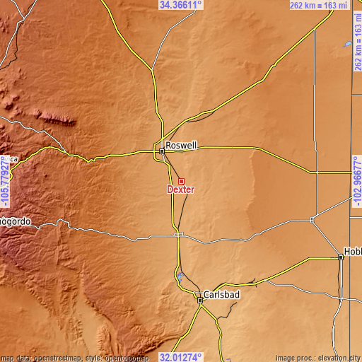
| \ | Map #1 | Topo.Map |
| Scale [m] | 1036..1081 m | × |
| Scale [ft] | 3399..3547 ft | × |
| Average | 1056.2 m = 3465 ft | × |
| Width | 8.18 km = 5.1 mi | 261.7 km = 162.6 mi |
| Height | 8.18 km = 5.1 mi | 261.7 km = 162.6 mi |
| ↑Max Latitude | 33.234095° | 34.36611° |
| Latitude at center | 33.19733° | 33.19733° |
| ↓Min Latitude | 33.160549° | 32.01274° |
| ← Min Longitude | -104.416965° | -105.77927° |
| Longitude center | -104.37302° | -104.37302° |
| →Max Longitude | -104.329075° | -102.96677° |
Nearby cities:
Cities around Dexter sort by population:
• Roswell elevation 1093 m
26.1 km,  327°
327°
• Hobbs 1104 m
127.9 km,  115°
115°
• Carlsbad 951 m
87.4 km,  171°
171°
• Artesia 1036 m
39.6 km,  184°
184°
• Lovington 1195 m
99.5 km,  106°
106°
• Ruidoso 2057 m
121.8 km,  277°
277°
• Ruidoso Downs 1961 m
115.4 km, 277°
• Loving 933 m
104.6 km, 165°
• Capitan 1941 m
117.9 km,  289°
289°
• Hagerman 1044 m
10.1 km,  154°
154°
• La Huerta 955 m
85.1 km, 170°
• Atoka 1030 m
47.6 km, 181°
Multilingual:
 En español:
Dexter elevación 1059 m.
 En France:
Dexter élévation 1059 m.


Sources and notes:
- [note 1] Map square and city borders are not equal. Map elevation data is calculated only from area inside that square.
- [src 1] Elevation data from geonames database provided with same terms of usage.
- [src 2] The elevation map of Dexter is generated using elevation data from NASA's 3 arcsec (90m) resolution SRTM data.
- [src 3] Base (background) map © OpenStreetMap contributors tiles are generated by Geofabrik and OpenTopoMap.
Copyright & License:
This Dexter Elevation Map is licensed under CC BY-SA. You may reuse any part from this page, if you give a proper credit by linking to this URL:
 More info on terms of use page.