Wheat Ridge elevation
Wheat Ridge (Colorado, Jefferson County), United States elevation is 1669 meters and Wheat Ridge elevation in feet is 5476 ft above sea level [src 1]. Wheat Ridge is a populated place (feature code) with elevation that is 1390 meters (4560 ft) bigger than average city elevation in United States.
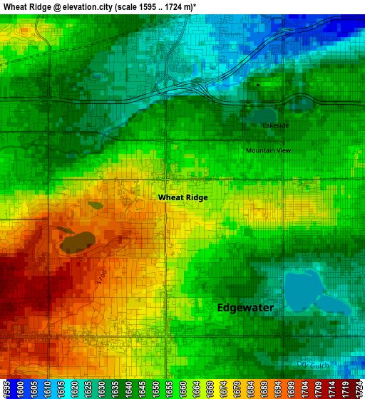
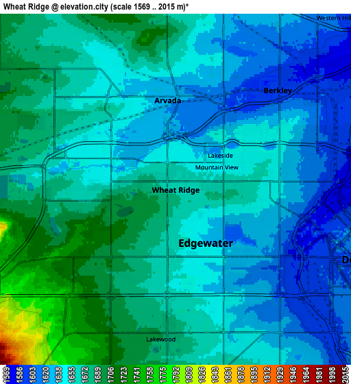
Below is the Elevation map of Wheat Ridge, which displays elevation range with different colors. Scale of the first map is from 1595 to 1724 m (5233 to 5656 ft) with average elevation of 1653.3 meters (=5424 ft) [note 1]
These maps also provides idea of topography and contour of this city, they are displayed at different zoom levels. More info about maps, scale and edge coordinates you can find below images.
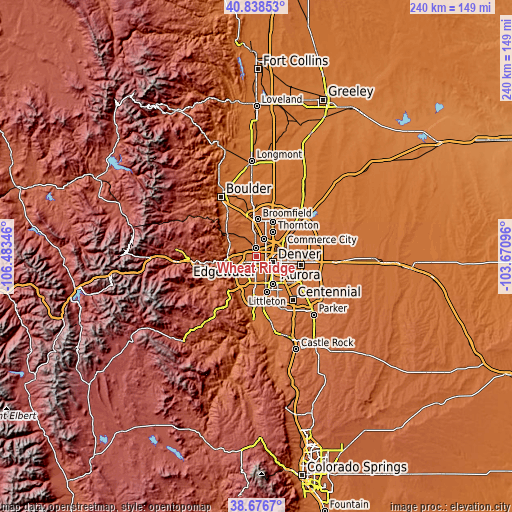
| \ | Map #1 | Map #2 | Topo.Map |
| Scale [m] | 1595..1724 m | 1569..2015 m | × |
| Scale [ft] | 5233..5656 ft | 5148..6611 ft | × |
| Average | 1653.3 m = 5424 ft | 1658.2 m = 5440 ft | × |
| Width | 7.51 km = 4.7 mi | 15.02 km = 9.3 mi | 240.4 km = 149.4 mi |
| Height | 7.51 km = 4.7 mi | 15.02 km = 9.3 mi | 240.4 km = 149.4 mi |
| ↑Max Latitude | 39.799871° | 39.833625° | 40.83853° |
| Latitude at center | 39.7661° | 39.7661° | 39.7661° |
| ↓Min Latitude | 39.732313° | 39.698509° | 38.6767° |
| ← Min Longitude | -105.121155° | -105.165101° | -106.48346° |
| Longitude center | -105.07721° | -105.07721° | -105.07721° |
| →Max Longitude | -105.033265° | -104.989319° | -103.67096° |
Nearby cities:
Cities around Wheat Ridge sort by population:
• Denver elevation 1636 m
8.5 km,  110°
110°
• Lakewood 1682 m
6.8 km,  182°
182°
• Arvada 1637 m
4.2 km,  347°
347°
• Westminster 1644 m
8.6 km,  23°
23°
• Sherrelwood 1618 m
10.3 km,  39°
39°
• Federal Heights 1618 m
11.6 km, 35°
• Berkley 1593 m
6.1 km,  45°
45°
• Applewood 1707 m
7.3 km,  262°
262°
• Twin Lakes 1602 m
9 km, 43°
• Edgewater 1645 m
1.8 km,  142°
142°
• Shaw Heights 1665 m
10 km, 16°
• West Pleasant View 1775 m
9.4 km,  246°
246°
Multilingual:
 En español:
Wheat Ridge elevación 1669 m.
 En France:
Wheat Ridge élévation 1669 m.
 Auf Deutsch:
Wheat Ridge höhe über dem Meeresspiegel ist 1669 m.

Sources and notes:
- [note 1] Map square and city borders are not equal. Map elevation data is calculated only from area inside that square.
- [src 1] Elevation data from geonames database provided with same terms of usage.
- [src 2] The elevation map of Wheat Ridge is generated using elevation data from NASA's 3 arcsec (90m) resolution SRTM data.
- [src 3] Base (background) map © OpenStreetMap contributors tiles are generated by Geofabrik and OpenTopoMap.
Copyright & License:
This Wheat Ridge Elevation Map is licensed under CC BY-SA. You may reuse any part from this page, if you give a proper credit by linking to this URL:
 More info on terms of use page.