Indian Hills elevation
Indian Hills (Colorado, Jefferson County), United States elevation is 2099 meters and Indian Hills elevation in feet is 6886 ft above sea level [src 1]. Indian Hills is a populated place (feature code) with elevation that is 1820 meters (5971 ft) bigger than average city elevation in United States.
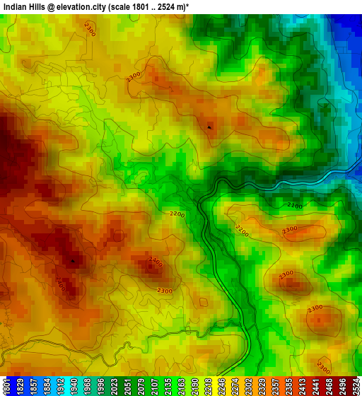
Below is the Elevation map of Indian Hills, which displays elevation range with different colors. Scale of the first map is from 1801 to 2524 m (5909 to 8281 ft) with average elevation of 2224.5 meters (=7298 ft) [note 1]
These maps also provides idea of topography and contour of this city, they are displayed at different zoom levels. More info about maps, scale and edge coordinates you can find below images.
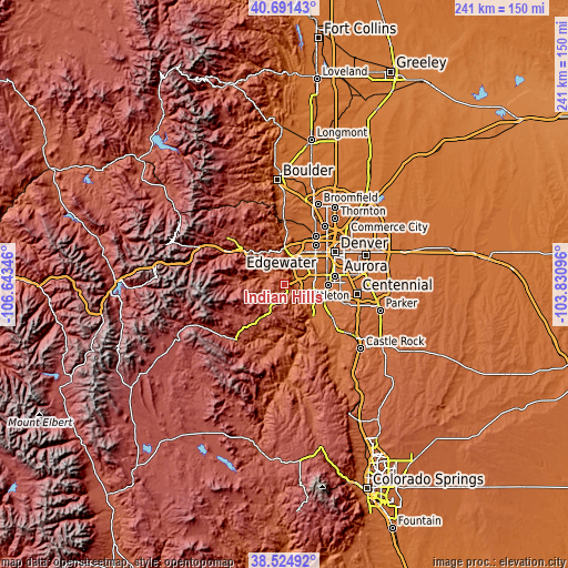
| \ | Map #1 | Topo.Map |
| Scale [m] | 1801..2524 m | × |
| Scale [ft] | 5909..8281 ft | × |
| Average | 2224.5 m = 7298 ft | × |
| Width | 7.53 km = 4.7 mi | 240.9 km = 149.7 mi |
| Height | 7.53 km = 4.7 mi | 240.9 km = 149.7 mi |
| ↑Max Latitude | 39.650494° | 40.69143° |
| Latitude at center | 39.61665° | 39.61665° |
| ↓Min Latitude | 39.582789° | 38.52492° |
| ← Min Longitude | -105.281155° | -106.64346° |
| Longitude center | -105.23721° | -105.23721° |
| →Max Longitude | -105.193265° | -103.83096° |
Nearby cities:
Cities around Indian Hills sort by population:
• Lakewood elevation 1682 m
16.5 km,  53°
53°
• Ken Caryl 1761 m
11.6 km,  112°
112°
• Columbine 1691 m
14.7 km,  102°
102°
• Golden 1733 m
15.5 km,  5°
5°
• Evergreen 2155 m
7.1 km,  285°
285°
• Applewood 1707 m
16.9 km,  22°
22°
• Sheridan 1625 m
18.5 km,  79°
79°
• West Pleasant View 1775 m
13.8 km, 21°
• Genesee 2336 m
8.3 km,  338°
338°
• Columbine Valley 1635 m
17.6 km, 95°
• Kittredge 2102 m
6.8 km,  308°
308°
• Upper Bear Creek 2360 m
15.5 km,  272°
272°
Multilingual:
 En español:
Indian Hills elevación 2099 m.
 En France:
Indian Hills élévation 2099 m.
 Auf Deutsch:
Indian Hills höhe über dem Meeresspiegel ist 2099 m.

Sources and notes:
- [note 1] Map square and city borders are not equal. Map elevation data is calculated only from area inside that square.
- [src 1] Elevation data from geonames database provided with same terms of usage.
- [src 2] The elevation map of Indian Hills is generated using elevation data from NASA's 3 arcsec (90m) resolution SRTM data.
- [src 3] Base (background) map © OpenStreetMap contributors tiles are generated by Geofabrik and OpenTopoMap.
Copyright & License:
This Indian Hills Elevation Map is licensed under CC BY-SA. You may reuse any part from this page, if you give a proper credit by linking to this URL:
 More info on terms of use page.