Black Forest elevation
Black Forest (Colorado, El Paso County), United States elevation is 2253 meters and Black Forest elevation in feet is 7392 ft above sea level [src 1]. Black Forest is a populated place (feature code) with elevation that is 1974 meters (6476 ft) bigger than average city elevation in United States.
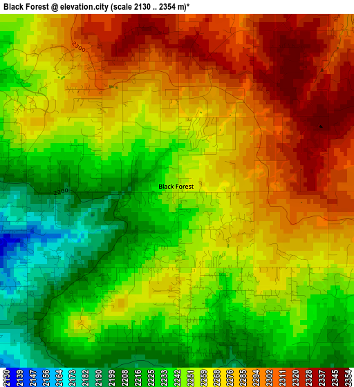
Below is the Elevation map of Black Forest, which displays elevation range with different colors. Scale of the first map is from 2130 to 2354 m (6988 to 7723 ft) with average elevation of 2259.9 meters (=7414 ft) [note 1]
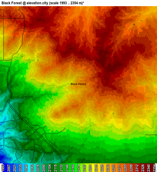
These maps also provides idea of topography and contour of this city, they are displayed at different zoom levels. More info about maps, scale and edge coordinates you can find below images.
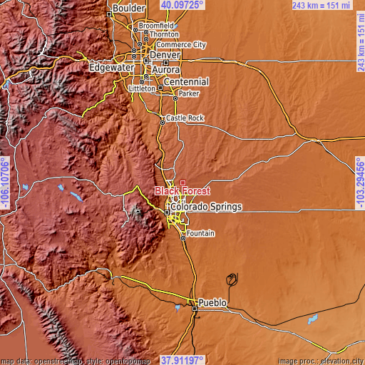
| \ | Map #1 | Map #2 | Topo.Map |
| Scale [m] | 2130..2354 m | 1993..2354 m | × |
| Scale [ft] | 6988..7723 ft | 6539..7723 ft | × |
| Average | 2259.9 m = 7414 ft | 2224.6 m = 7299 ft | × |
| Width | 7.59 km = 4.7 mi | 15.19 km = 9.4 mi | 243 km = 151 mi |
| Height | 7.59 km = 4.7 mi | 15.19 km = 9.4 mi | 243 km = 151 mi |
| ↑Max Latitude | 39.047187° | 39.081308° | 40.09725° |
| Latitude at center | 39.01305° | 39.01305° | 39.01305° |
| ↓Min Latitude | 38.978896° | 38.944726° | 37.91197° |
| ← Min Longitude | -104.744755° | -104.788701° | -106.10706° |
| Longitude center | -104.70081° | -104.70081° | -104.70081° |
| →Max Longitude | -104.656865° | -104.612919° | -103.29456° |
Nearby cities:
Cities around Black Forest sort by population:
• Colorado Springs elevation 1838 m
22.5 km,  207°
207°
• Security-Widefield 1783 m
29.6 km,  182°
182°
• Cimarron Hills 1965 m
17.2 km, 179°
• Woodmoor 2217 m
16 km,  307°
307°
• Woodland Park 2590 m
30.8 km,  266°
266°
• Stratmoor 1764 m
27.5 km,  194°
194°
• Air Force Academy 2070 m
14.2 km,  261°
261°
• Gleneagle 2114 m
11.3 km,  288°
288°
• Monument 2132 m
17.2 km,  300°
300°
• Manitou Springs 1946 m
25.3 km,  227°
227°
• Palmer Lake 2233 m
22.3 km, 303°
• Cascade-Chipita Park 2570 m
27.2 km,  253°
253°
Multilingual:
 En español:
Black Forest elevación 2253 m.
 En France:
Black Forest élévation 2253 m.
 Auf Deutsch:
Black Forest höhe über dem Meeresspiegel ist 2253 m.

Sources and notes:
- [note 1] Map square and city borders are not equal. Map elevation data is calculated only from area inside that square.
- [src 1] Elevation data from geonames database provided with same terms of usage.
- [src 2] The elevation map of Black Forest is generated using elevation data from NASA's 3 arcsec (90m) resolution SRTM data.
- [src 3] Base (background) map © OpenStreetMap contributors tiles are generated by Geofabrik and OpenTopoMap.
Copyright & License:
This Black Forest Elevation Map is licensed under CC BY-SA. You may reuse any part from this page, if you give a proper credit by linking to this URL:
 More info on terms of use page.