Woodland elevation
Woodland (California, Yolo County), United States elevation is 21 meters and Woodland elevation in feet is 69 ft above sea level [src 1]. Woodland is a seat of a second-order administrative division (feature code) with elevation that is 258 meters (846 ft) smaller than average city elevation in United States.
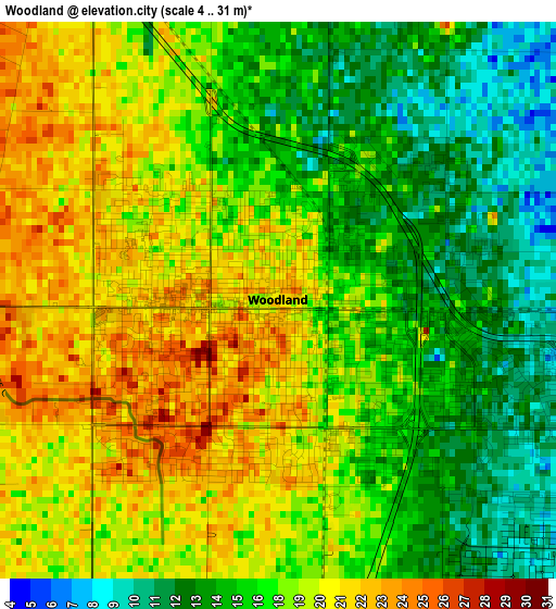
Below is the Elevation map of Woodland, which displays elevation range with different colors. Scale of the first map is from 4 to 31 m (13 to 102 ft) with average elevation of 17.4 meters (=57 ft) [note 1]
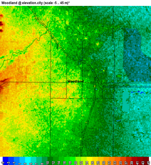
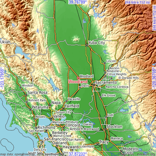
These maps also provides idea of topography and contour of this city, they are displayed at different zoom levels. More info about maps, scale and edge coordinates you can find below images.
| \ | Map #1 | Map #2 | Topo.Map |
| Scale [m] | 4..31 m | -5..45 m | × |
| Scale [ft] | 13..102 ft | -16..148 ft | × |
| Average | 17.4 m = 57 ft | 16.1 m = 53 ft | × |
| Width | 7.63 km = 4.7 mi | 15.26 km = 9.5 mi | 244.1 km = 151.7 mi |
| Height | 7.63 km = 4.7 mi | 15.26 km = 9.5 mi | 244.1 km = 151.7 mi |
| ↑Max Latitude | 38.712818° | 38.7471° | 39.76789° |
| Latitude at center | 38.67852° | 38.67852° | 38.67852° |
| ↓Min Latitude | 38.644205° | 38.609874° | 37.57232° |
| ← Min Longitude | -121.817245° | -121.861191° | -123.17955° |
| Longitude center | -121.7733° | -121.7733° | -121.7733° |
| →Max Longitude | -121.729355° | -121.685409° | -120.36705° |
Nearby cities:
Cities around Woodland sort by population:
• Sacramento elevation 14 m
26.5 km,  113°
113°
• Davis 17 m
15.1 km,  169°
169°
• West Sacramento 4 m
23.8 km,  117°
117°
• Dixon 20 m
26.3 km,  189°
189°
• Rio Linda 18 m
28.2 km,  87°
87°
• Winters 39 m
24.2 km,  225°
225°
• Elverta 17 m
27.2 km,  81°
81°
• Cottonwood 52 m
17.3 km,  262°
262°
• Esparto 58 m
21.2 km,  274°
274°
• Monument Hills 38 m
9 km, 259°
• Allendale 36 m
29.9 km,  209°
209°
• Dunnigan 23 m
28.6 km,  323°
323°
Multilingual:
 En español:
Woodland elevación 21 m.
 En France:
Woodland élévation 21 m.


Sources and notes:
- [note 1] Map square and city borders are not equal. Map elevation data is calculated only from area inside that square.
- [src 1] Elevation data from geonames database provided with same terms of usage.
- [src 2] The elevation map of Woodland is generated using elevation data from NASA's 3 arcsec (90m) resolution SRTM data.
- [src 3] Base (background) map © OpenStreetMap contributors tiles are generated by Geofabrik and OpenTopoMap.
Copyright & License:
This Woodland Elevation Map is licensed under CC BY-SA. You may reuse any part from this page, if you give a proper credit by linking to this URL:
 More info on terms of use page.