Westmont elevation
Westmont (California, Los Angeles County), United States elevation is 67 meters and Westmont elevation in feet is 220 ft above sea level [src 1]. Westmont is a populated place (feature code) with elevation that is 212 meters (696 ft) smaller than average city elevation in United States.
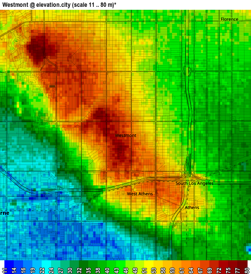
Below is the Elevation map of Westmont, which displays elevation range with different colors. Scale of the first map is from 11 to 80 m (36 to 262 ft) with average elevation of 44.8 meters (=147 ft) [note 1]
These maps also provides idea of topography and contour of this city, they are displayed at different zoom levels. More info about maps, scale and edge coordinates you can find below images.
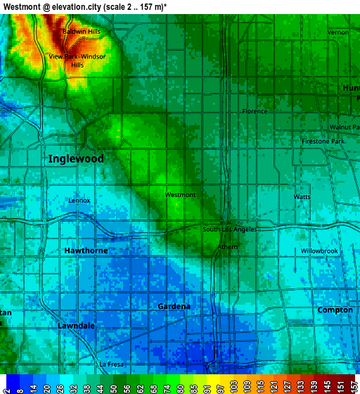
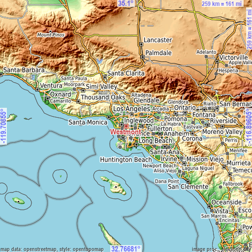
| \ | Map #1 | Map #2 | Topo.Map |
| Scale [m] | 11..80 m | 2..157 m | × |
| Scale [ft] | 36..262 ft | 7..515 ft | × |
| Average | 44.8 m = 147 ft | 41.3 m = 135 ft | × |
| Width | 8.11 km = 5 mi | 16.21 km = 10.1 mi | 259.4 km = 161.2 mi |
| Height | 8.11 km = 5 mi | 16.21 km = 10.1 mi | 259.4 km = 161.2 mi |
| ↑Max Latitude | 33.97785° | 34.014284° | 35.1° |
| Latitude at center | 33.9414° | 33.9414° | 33.9414° |
| ↓Min Latitude | 33.904935° | 33.868454° | 32.76681° |
| ← Min Longitude | -118.346245° | -118.390191° | -119.70855° |
| Longitude center | -118.3023° | -118.3023° | -118.3023° |
| →Max Longitude | -118.258355° | -118.214409° | -116.89605° |
Nearby cities:
Cities around Westmont sort by population:
• Inglewood elevation 44 m
5.2 km,  295°
295°
• Hawthorne 24 m
5.4 km,  239°
239°
• Florence-Graham 46 m
6.1 km,  61°
61°
• Gardena 18 m
5.9 km,  185°
185°
• Willowbrook 33 m
5.1 km,  121°
121°
• Lawndale 19 m
7.6 km,  217°
217°
• Lennox 23 m
4.7 km,  265°
265°
• View Park-Windsor Hills 106 m
7.4 km,  324°
324°
• Del Aire 33 m
6.8 km,  245°
245°
• West Athens 58 m
2 km,  182°
182°
• Alondra Park 21 m
6.3 km,  204°
204°
• West Rancho Dominguez 27 m
6 km,  151°
151°
Multilingual:
 En español:
Westmont elevación 67 m.
 En France:
Westmont élévation 67 m.


Sources and notes:
- [note 1] Map square and city borders are not equal. Map elevation data is calculated only from area inside that square.
- [src 1] Elevation data from geonames database provided with same terms of usage.
- [src 2] The elevation map of Westmont is generated using elevation data from NASA's 3 arcsec (90m) resolution SRTM data.
- [src 3] Base (background) map © OpenStreetMap contributors tiles are generated by Geofabrik and OpenTopoMap.
Copyright & License:
This Westmont Elevation Map is licensed under CC BY-SA. You may reuse any part from this page, if you give a proper credit by linking to this URL:
 More info on terms of use page.