Summerland elevation
Summerland (California, Santa Barbara County), United States elevation is 43 meters and Summerland elevation in feet is 141 ft above sea level [src 1]. Summerland is a populated place (feature code) with elevation that is 236 meters (774 ft) smaller than average city elevation in United States.
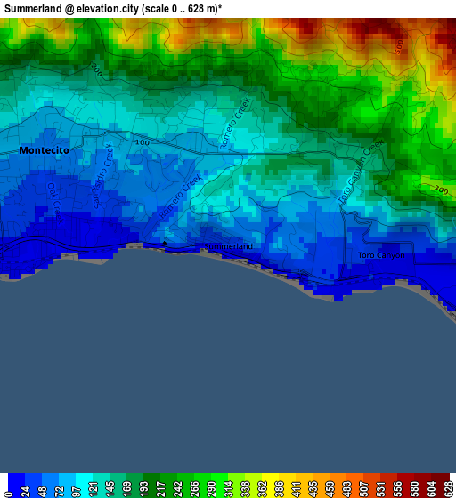
Below is the Elevation map of Summerland, which displays elevation range with different colors. Scale of the first map is from 0 to 628 m (0 to 2060 ft) with average elevation of 169 meters (=554 ft) [note 1]
These maps also provides idea of topography and contour of this city, they are displayed at different zoom levels. More info about maps, scale and edge coordinates you can find below images.
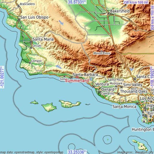
| \ | Map #1 | Topo.Map |
| Scale [m] | 0..628 m | × |
| Scale [ft] | 0..2060 ft | × |
| Average | 169 m = 554 ft | × |
| Width | 8.06 km = 5 mi | 258 km = 160.3 mi |
| Height | 8.06 km = 5 mi | 258 km = 160.3 mi |
| ↑Max Latitude | 34.457623° | 35.57331° |
| Latitude at center | 34.42138° | 34.42138° |
| ↓Min Latitude | 34.385122° | 33.25336° |
| ← Min Longitude | -119.640465° | -121.00277° |
| Longitude center | -119.59652° | -119.59652° |
| →Max Longitude | -119.552575° | -118.19027° |
Nearby cities:
Cities around Summerland sort by population:
• Ventura elevation 12 m
32.1 km,  119°
119°
• Santa Barbara 16 m
9.3 km,  269°
269°
• Goleta 7 m
21.3 km, 274°
• Isla Vista 15 m
24.3 km, 267°
• Carpinteria 9 m
7.6 km,  109°
109°
• Montecito 62 m
3.7 km,  297°
297°
• Ojai 232 m
32.6 km,  84°
84°
• Mira Monte 199 m
28.6 km,  87°
87°
• Oak View 164 m
27.3 km, 94°
• Meiners Oaks 231 m
29.2 km, 84°
• Mission Canyon 191 m
11.2 km,  287°
287°
• Toro Canyon 21 m
2.7 km, 93°
Multilingual:
 En español:
Summerland elevación 43 m.
 En France:
Summerland élévation 43 m.
 Auf Deutsch:
Summerland höhe über dem Meeresspiegel ist 43 m.

Sources and notes:
- [note 1] Map square and city borders are not equal. Map elevation data is calculated only from area inside that square.
- [src 1] Elevation data from geonames database provided with same terms of usage.
- [src 2] The elevation map of Summerland is generated using elevation data from NASA's 3 arcsec (90m) resolution SRTM data.
- [src 3] Base (background) map © OpenStreetMap contributors tiles are generated by Geofabrik and OpenTopoMap.
Copyright & License:
This Summerland Elevation Map is licensed under CC BY-SA. You may reuse any part from this page, if you give a proper credit by linking to this URL:
 More info on terms of use page.