Santee elevation
Santee (California, San Diego County), United States elevation is 108 meters and Santee elevation in feet is 354 ft above sea level [src 1]. Santee is a populated place (feature code) with elevation that is 171 meters (561 ft) smaller than average city elevation in United States.
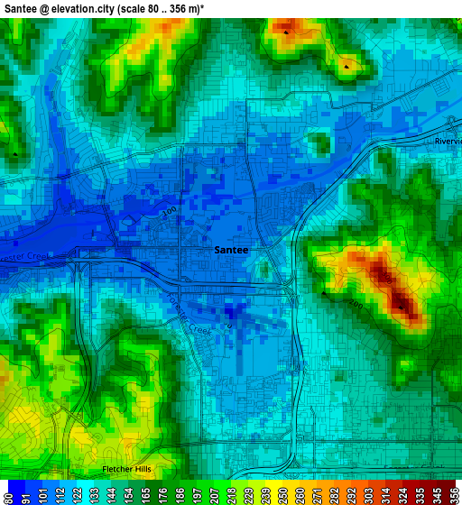
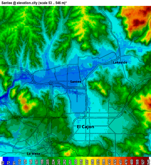
Below is the Elevation map of Santee, which displays elevation range with different colors. Scale of the first map is from 80 to 356 m (262 to 1168 ft) with average elevation of 151 meters (=495 ft) [note 1]
These maps also provides idea of topography and contour of this city, they are displayed at different zoom levels. More info about maps, scale and edge coordinates you can find below images.
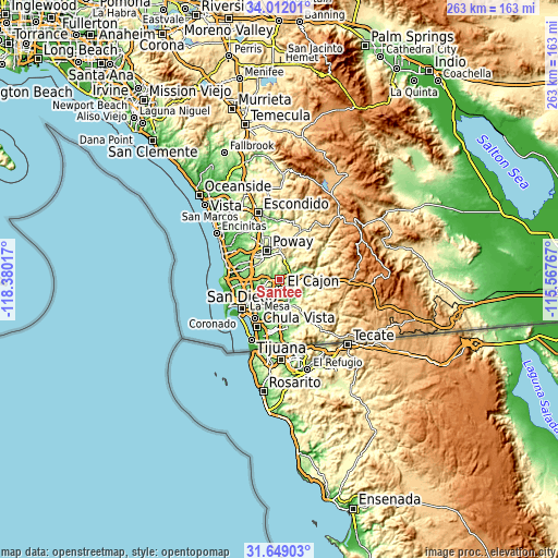
| \ | Map #1 | Map #2 | Topo.Map |
| Scale [m] | 80..356 m | 53..546 m | × |
| Scale [ft] | 262..1168 ft | 174..1791 ft | × |
| Average | 151 m = 495 ft | 197.7 m = 649 ft | × |
| Width | 8.21 km = 5.1 mi | 16.42 km = 10.2 mi | 262.7 km = 163.2 mi |
| Height | 8.21 km = 5.1 mi | 16.42 km = 10.2 mi | 262.7 km = 163.2 mi |
| ↑Max Latitude | 32.875295° | 32.912195° | 34.01201° |
| Latitude at center | 32.83838° | 32.83838° | 32.83838° |
| ↓Min Latitude | 32.801449° | 32.764503° | 31.64903° |
| ← Min Longitude | -117.017865° | -117.061811° | -118.38017° |
| Longitude center | -116.97392° | -116.97392° | -116.97392° |
| →Max Longitude | -116.929975° | -116.886029° | -115.56767° |
Nearby cities:
Cities around Santee sort by population:
• El Cajon elevation 133 m
5 km,  167°
167°
• La Mesa 162 m
9.1 km,  210°
210°
• Spring Valley 121 m
10.7 km,  192°
192°
• Lemon Grove 135 m
11.9 km, 206°
• Rancho San Diego 110 m
10.8 km,  160°
160°
• Lakeside 126 m
5.3 km,  66°
66°
• Winter Gardens 206 m
3.9 km,  101°
101°
• Casa de Oro-Mount Helix 256 m
8.3 km,  176°
176°
• Bostonia 147 m
4.9 km,  134°
134°
• Eucalyptus Hills 201 m
5.3 km,  28°
28°
• Granite Hills 200 m
7.6 km,  121°
121°
• Crest 500 m
10.5 km,  109°
109°
Multilingual:
 En español:
Santee elevación 108 m.
 En France:
Santee élévation 108 m.


Sources and notes:
- [note 1] Map square and city borders are not equal. Map elevation data is calculated only from area inside that square.
- [src 1] Elevation data from geonames database provided with same terms of usage.
- [src 2] The elevation map of Santee is generated using elevation data from NASA's 3 arcsec (90m) resolution SRTM data.
- [src 3] Base (background) map © OpenStreetMap contributors tiles are generated by Geofabrik and OpenTopoMap.
Copyright & License:
This Santee Elevation Map is licensed under CC BY-SA. You may reuse any part from this page, if you give a proper credit by linking to this URL:
 More info on terms of use page.