Santa Paula elevation
Santa Paula (California, Ventura County), United States elevation is 87 meters and Santa Paula elevation in feet is 285 ft above sea level [src 1]. Santa Paula is a populated place (feature code) with elevation that is 192 meters (630 ft) smaller than average city elevation in United States.
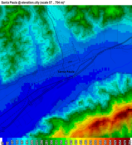
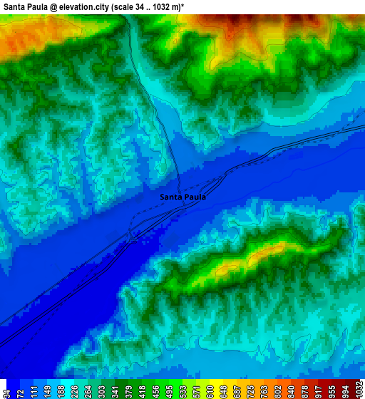
Below is the Elevation map of Santa Paula, which displays elevation range with different colors. Scale of the first map is from 57 to 704 m (187 to 2310 ft) with average elevation of 188.7 meters (=619 ft) [note 1]
These maps also provides idea of topography and contour of this city, they are displayed at different zoom levels. More info about maps, scale and edge coordinates you can find below images.
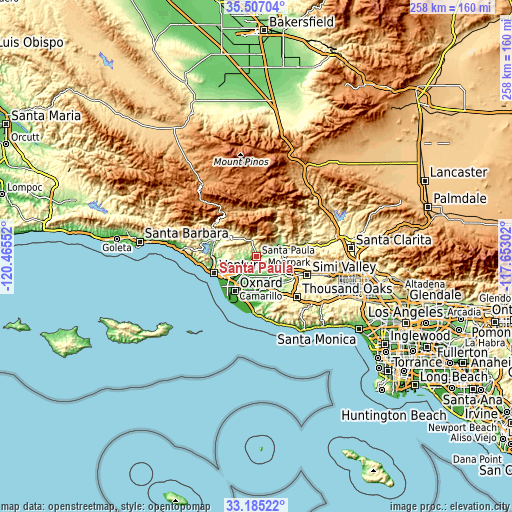
| \ | Map #1 | Map #2 | Topo.Map |
| Scale [m] | 57..704 m | 34..1032 m | × |
| Scale [ft] | 187..2310 ft | 112..3386 ft | × |
| Average | 188.7 m = 619 ft | 255.1 m = 837 ft | × |
| Width | 8.07 km = 5 mi | 16.14 km = 10 mi | 258.2 km = 160.4 mi |
| Height | 8.07 km = 5 mi | 16.14 km = 10 mi | 258.2 km = 160.4 mi |
| ↑Max Latitude | 34.390442° | 34.426698° | 35.50704° |
| Latitude at center | 34.35417° | 34.35417° | 34.35417° |
| ↓Min Latitude | 34.317882° | 34.281579° | 33.18522° |
| ← Min Longitude | -119.103215° | -119.147161° | -120.46552° |
| Longitude center | -119.05927° | -119.05927° | -119.05927° |
| →Max Longitude | -119.015325° | -118.971379° | -117.65302° |
Nearby cities:
Cities around Santa Paula sort by population:
• Oxnard elevation 19 m
20.5 km,  211°
211°
• Ventura 12 m
23.1 km,  248°
248°
• Camarillo 55 m
15.4 km,  172°
172°
• Moorpark 160 m
18 km,  115°
115°
• Fillmore 143 m
13.9 km,  68°
68°
• Ojai 232 m
19.8 km,  301°
301°
• El Rio 29 m
16.3 km,  216°
216°
• Mira Monte 199 m
22.5 km,  293°
293°
• Oak View 164 m
22.7 km,  282°
282°
• Meiners Oaks 231 m
22.7 km, 297°
• Casa Conejo 203 m
21.7 km,  150°
150°
• Saticoy 48 m
11.5 km,  226°
226°
Multilingual:
 En español:
Santa Paula elevación 87 m.
 En France:
Santa Paula élévation 87 m.
 Auf Deutsch:
Santa Paula höhe über dem Meeresspiegel ist 87 m.

Sources and notes:
- [note 1] Map square and city borders are not equal. Map elevation data is calculated only from area inside that square.
- [src 1] Elevation data from geonames database provided with same terms of usage.
- [src 2] The elevation map of Santa Paula is generated using elevation data from NASA's 3 arcsec (90m) resolution SRTM data.
- [src 3] Base (background) map © OpenStreetMap contributors tiles are generated by Geofabrik and OpenTopoMap.
Copyright & License:
This Santa Paula Elevation Map is licensed under CC BY-SA. You may reuse any part from this page, if you give a proper credit by linking to this URL:
 More info on terms of use page.