San Rafael elevation
San Rafael (California, Marin County), United States elevation is 13 meters and San Rafael elevation in feet is 43 ft above sea level [src 1]. San Rafael is a seat of a second-order administrative division (feature code) with elevation that is 266 meters (873 ft) smaller than average city elevation in United States.
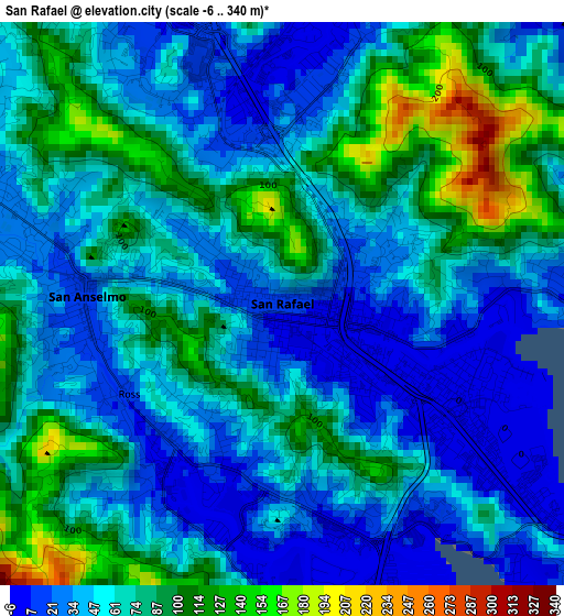
Below is the Elevation map of San Rafael, which displays elevation range with different colors. Scale of the first map is from -6 to 340 m (-20 to 1115 ft) with average elevation of 62.5 meters (=205 ft) [note 1]
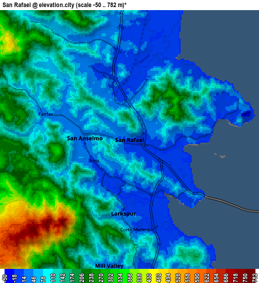
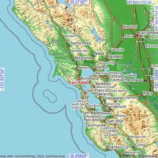
These maps also provides idea of topography and contour of this city, they are displayed at different zoom levels. More info about maps, scale and edge coordinates you can find below images.
| \ | Map #1 | Map #2 | Topo.Map |
| Scale [m] | -6..340 m | -50..782 m | × |
| Scale [ft] | -20..1115 ft | -164..2566 ft | × |
| Average | 62.5 m = 205 ft | 131.4 m = 431 ft | × |
| Width | 7.7 km = 4.8 mi | 15.41 km = 9.6 mi | 246.5 km = 153.2 mi |
| Height | 7.7 km = 4.8 mi | 15.41 km = 9.6 mi | 246.5 km = 153.2 mi |
| ↑Max Latitude | 38.008164° | 38.042781° | 39.07367° |
| Latitude at center | 37.97353° | 37.97353° | 37.97353° |
| ↓Min Latitude | 37.93888° | 37.904214° | 36.85665° |
| ← Min Longitude | -122.575035° | -122.618981° | -123.93734° |
| Longitude center | -122.53109° | -122.53109° | -122.53109° |
| →Max Longitude | -122.487145° | -122.443199° | -121.12484° |
Nearby cities:
Cities around San Rafael sort by population:
• Mill Valley elevation 23 m
7.6 km,  189°
189°
• San Anselmo 15 m
2.7 km,  272°
272°
• Larkspur 14 m
4.4 km,  184°
184°
• Corte Madera 8 m
5.4 km, 176°
• Fairfax 35 m
5.3 km,  286°
286°
• Tamalpais Valley 33 m
10.5 km, 187°
• Kentfield 57 m
3.3 km,  223°
223°
• Lucas Valley-Marinwood 209 m
8.4 km,  332°
332°
• Strawberry 66 m
8.7 km,  167°
167°
• Santa Venetia 21 m
2.8 km,  10°
10°
• Ross 14 m
2.4 km,  239°
239°
• Sleepy Hollow 60 m
6.2 km,  311°
311°
Multilingual:
 En español:
San Rafael elevación 13 m.
 En France:
San Rafael élévation 13 m.
 Auf Deutsch:
San Rafael höhe über dem Meeresspiegel ist 13 m.

Sources and notes:
- [note 1] Map square and city borders are not equal. Map elevation data is calculated only from area inside that square.
- [src 1] Elevation data from geonames database provided with same terms of usage.
- [src 2] The elevation map of San Rafael is generated using elevation data from NASA's 3 arcsec (90m) resolution SRTM data.
- [src 3] Base (background) map © OpenStreetMap contributors tiles are generated by Geofabrik and OpenTopoMap.
Copyright & License:
This San Rafael Elevation Map is licensed under CC BY-SA. You may reuse any part from this page, if you give a proper credit by linking to this URL:
 More info on terms of use page.