Rolling Hills elevation
Rolling Hills (California, Los Angeles County), United States elevation is 371 meters and Rolling Hills elevation in feet is 1217 ft above sea level [src 1]. Rolling Hills is a populated place (feature code) with elevation that is 92 meters (302 ft) bigger than average city elevation in United States.
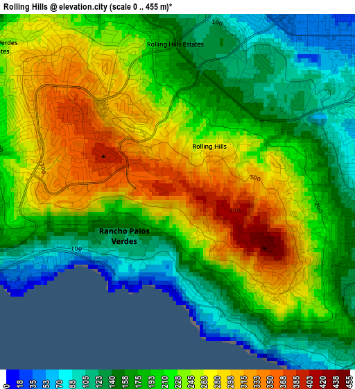
Below is the Elevation map of Rolling Hills, which displays elevation range with different colors. Scale of the first map is from 0 to 455 m (0 to 1493 ft) with average elevation of 211.2 meters (=693 ft) [note 1]
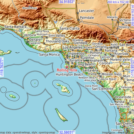
These maps also provides idea of topography and contour of this city, they are displayed at different zoom levels. More info about maps, scale and edge coordinates you can find below images.
| \ | Map #1 | Topo.Map |
| Scale [m] | 0..455 m | × |
| Scale [ft] | 0..1493 ft | × |
| Average | 211.2 m = 693 ft | × |
| Width | 8.12 km = 5 mi | 260 km = 161.6 mi |
| Height | 8.12 km = 5 mi | 260 km = 161.6 mi |
| ↑Max Latitude | 33.793918° | 34.91853° |
| Latitude at center | 33.75739° | 33.75739° |
| ↓Min Latitude | 33.720846° | 32.58031° |
| ← Min Longitude | -118.401465° | -119.76377° |
| Longitude center | -118.35752° | -118.35752° |
| →Max Longitude | -118.313575° | -116.95127° |
Nearby cities:
Cities around Rolling Hills sort by population:
• Torrance elevation 33 m
8.9 km,  10°
10°
• Carson 16 m
10.8 km,  40°
40°
• San Pedro 37 m
6.5 km,  111°
111°
• Redondo Beach 22 m
10.6 km,  344°
344°
• Rancho Palos Verdes 67 m
3.1 km,  242°
242°
• Lawndale 19 m
14.4 km,  1°
1°
• West Carson 16 m
9.3 km, 40°
• Lomita 33 m
5.5 km,  45°
45°
• Hermosa Beach 14 m
12.3 km, 341°
• Palos Verdes Estates 56 m
5.8 km,  326°
326°
• Alondra Park 21 m
14.9 km, 9°
• Rolling Hills Estates 149 m
3.4 km,  359°
359°
Multilingual:
 En español:
Rolling Hills elevación 371 m.
 En France:
Rolling Hills élévation 371 m.
 Auf Deutsch:
Rolling Hills höhe über dem Meeresspiegel ist 371 m.

Sources and notes:
- [note 1] Map square and city borders are not equal. Map elevation data is calculated only from area inside that square.
- [src 1] Elevation data from geonames database provided with same terms of usage.
- [src 2] The elevation map of Rolling Hills is generated using elevation data from NASA's 3 arcsec (90m) resolution SRTM data.
- [src 3] Base (background) map © OpenStreetMap contributors tiles are generated by Geofabrik and OpenTopoMap.
Copyright & License:
This Rolling Hills Elevation Map is licensed under CC BY-SA. You may reuse any part from this page, if you give a proper credit by linking to this URL:
 More info on terms of use page.