Piñon Hills elevation
Piñon Hills (California, San Bernardino County), United States elevation is 1274 meters and Piñon Hills elevation in feet is 4180 ft above sea level [src 1]. Piñon Hills is a populated place (feature code) with elevation that is 995 meters (3264 ft) bigger than average city elevation in United States.
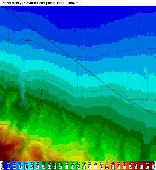
Below is the Elevation map of Piñon Hills, which displays elevation range with different colors. Scale of the first map is from 1110 to 2054 m (3642 to 6739 ft) with average elevation of 1341.2 meters (=4400 ft) [note 1]
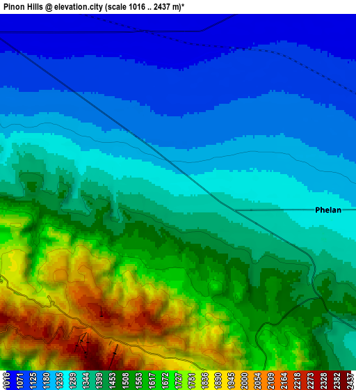
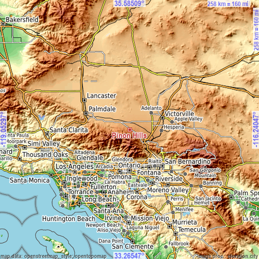
These maps also provides idea of topography and contour of this city, they are displayed at different zoom levels. More info about maps, scale and edge coordinates you can find below images.
| \ | Map #1 | Map #2 | Topo.Map |
| Scale [m] | 1110..2054 m | 1016..2437 m | × |
| Scale [ft] | 3642..6739 ft | 3333..7995 ft | × |
| Average | 1341.2 m = 4400 ft | 1405.6 m = 4612 ft | × |
| Width | 8.06 km = 5 mi | 16.12 km = 10 mi | 257.9 km = 160.3 mi |
| Height | 8.06 km = 5 mi | 16.12 km = 10 mi | 257.9 km = 160.3 mi |
| ↑Max Latitude | 34.469568° | 34.505789° | 35.58509° |
| Latitude at center | 34.43333° | 34.43333° | 34.43333° |
| ↓Min Latitude | 34.397077° | 34.360808° | 33.26547° |
| ← Min Longitude | -117.690665° | -117.734611° | -119.05297° |
| Longitude center | -117.64672° | -117.64672° | -117.64672° |
| →Max Longitude | -117.602775° | -117.558829° | -116.24047° |
Nearby cities:
Cities around Piñon Hills sort by population:
• Victorville elevation 834 m
34.5 km,  70°
70°
• Hesperia 967 m
31.7 km,  91°
91°
• Adelanto 881 m
27.4 km,  52°
52°
• Phelan 1260 m
6.9 km,  96°
96°
• Lake Los Angeles 812 m
25.9 km,  320°
320°
• Sun Village 834 m
31.7 km,  296°
296°
• Oak Hills 1134 m
25 km, 102°
• Spring Valley Lake 851 m
35.3 km,  79°
79°
• Wrightwood 1816 m
8.2 km,  171°
171°
• San Antonio Heights 648 m
30.9 km,  181°
181°
• Mountain View Acres 935 m
28.2 km, 75°
• Littlerock 887 m
32.4 km,  287°
287°
Multilingual:
 En español:
Piñon Hills elevación 1274 m.
 En France:
Piñon Hills élévation 1274 m.
 Auf Deutsch:
Piñon Hills höhe über dem Meeresspiegel ist 1274 m.

Sources and notes:
- [note 1] Map square and city borders are not equal. Map elevation data is calculated only from area inside that square.
- [src 1] Elevation data from geonames database provided with same terms of usage.
- [src 2] The elevation map of Piñon Hills is generated using elevation data from NASA's 3 arcsec (90m) resolution SRTM data.
- [src 3] Base (background) map © OpenStreetMap contributors tiles are generated by Geofabrik and OpenTopoMap.
Copyright & License:
This Piñon Hills Elevation Map is licensed under CC BY-SA. You may reuse any part from this page, if you give a proper credit by linking to this URL:
 More info on terms of use page.