Palmdale elevation
Palmdale (California, Los Angeles County), United States elevation is 815 meters and Palmdale elevation in feet is 2674 ft above sea level [src 1]. Palmdale is a populated place (feature code) with elevation that is 536 meters (1759 ft) bigger than average city elevation in United States.
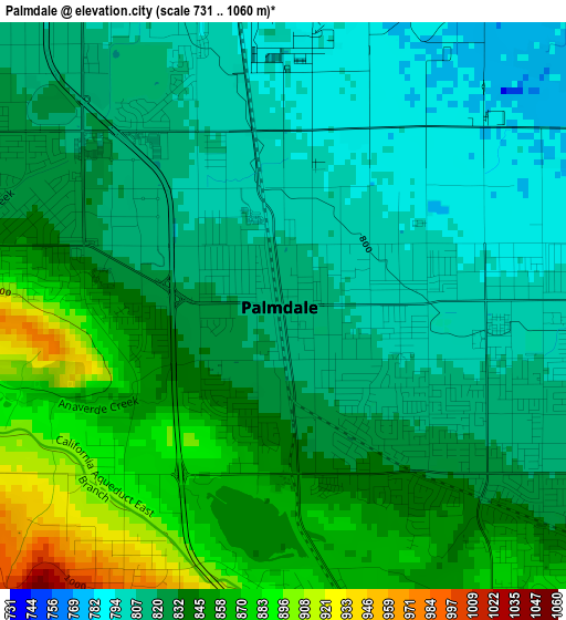
Below is the Elevation map of Palmdale, which displays elevation range with different colors. Scale of the first map is from 731 to 1060 m (2398 to 3478 ft) with average elevation of 831.6 meters (=2728 ft) [note 1]
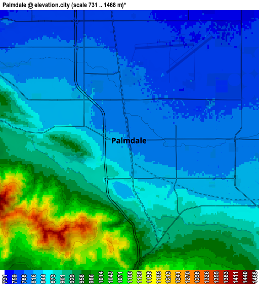
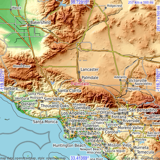
These maps also provides idea of topography and contour of this city, they are displayed at different zoom levels. More info about maps, scale and edge coordinates you can find below images.
| \ | Map #1 | Map #2 | Topo.Map |
| Scale [m] | 731..1060 m | 731..1468 m | × |
| Scale [ft] | 2398..3478 ft | 2398..4816 ft | × |
| Average | 831.6 m = 2728 ft | 880.8 m = 2890 ft | × |
| Width | 8.05 km = 5 mi | 16.09 km = 10 mi | 257.5 km = 160 mi |
| Height | 8.05 km = 5 mi | 16.09 km = 10 mi | 257.5 km = 160 mi |
| ↑Max Latitude | 34.615604° | 34.651762° | 35.72915° |
| Latitude at center | 34.57943° | 34.57943° | 34.57943° |
| ↓Min Latitude | 34.54324° | 34.507035° | 33.41359° |
| ← Min Longitude | -118.160405° | -118.204351° | -119.52271° |
| Longitude center | -118.11646° | -118.11646° | -118.11646° |
| →Max Longitude | -118.072515° | -118.028569° | -116.71021° |
Nearby cities:
Cities around Palmdale sort by population:
• Lancaster elevation 718 m
13.3 km,  351°
351°
• Rosamond 715 m
31.9 km, 352°
• Vincent 985 m
8.8 km,  180°
180°
• Lake Los Angeles 812 m
26.6 km,  82°
82°
• Sun Village 834 m
14.8 km,  98°
98°
• Quartz Hill 766 m
11.8 km,  308°
308°
• Acton 830 m
14.2 km,  211°
211°
• Agua Dulce 776 m
21.3 km,  244°
244°
• Desert View Highlands 831 m
3.5 km,  290°
290°
• Leona Valley 963 m
16.3 km, 285°
• Littlerock 887 m
13.8 km,  118°
118°
• Green Valley 894 m
27.6 km,  279°
279°
Multilingual:
 En español:
Palmdale elevación 815 m.
 En France:
Palmdale élévation 815 m.
 Auf Deutsch:
Palmdale höhe über dem Meeresspiegel ist 815 m.

Sources and notes:
- [note 1] Map square and city borders are not equal. Map elevation data is calculated only from area inside that square.
- [src 1] Elevation data from geonames database provided with same terms of usage.
- [src 2] The elevation map of Palmdale is generated using elevation data from NASA's 3 arcsec (90m) resolution SRTM data.
- [src 3] Base (background) map © OpenStreetMap contributors tiles are generated by Geofabrik and OpenTopoMap.
Copyright & License:
This Palmdale Elevation Map is licensed under CC BY-SA. You may reuse any part from this page, if you give a proper credit by linking to this URL:
 More info on terms of use page.