Maywood elevation
Maywood (California, Los Angeles County), United States elevation is 49 meters and Maywood elevation in feet is 161 ft above sea level [src 1]. Maywood is a populated place (feature code) with elevation that is 230 meters (755 ft) smaller than average city elevation in United States.
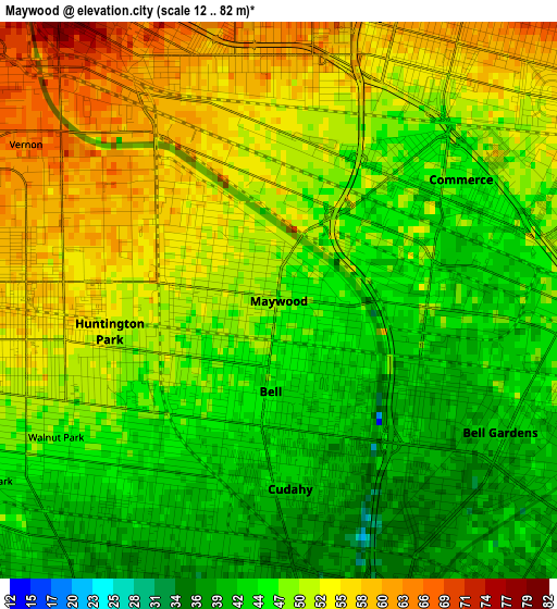
Below is the Elevation map of Maywood, which displays elevation range with different colors. Scale of the first map is from 12 to 82 m (39 to 269 ft) with average elevation of 48.9 meters (=160 ft) [note 1]
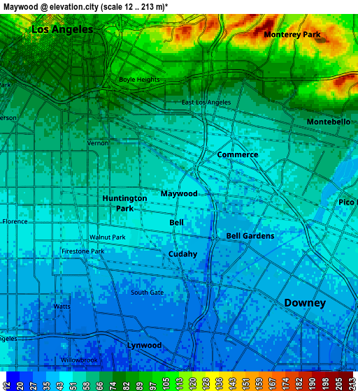
These maps also provides idea of topography and contour of this city, they are displayed at different zoom levels. More info about maps, scale and edge coordinates you can find below images.
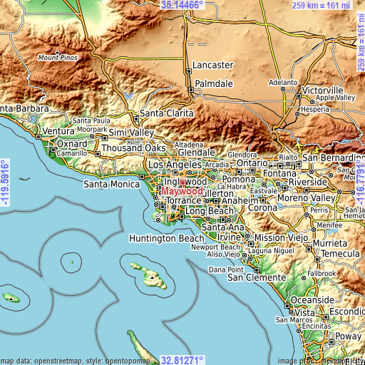
| \ | Map #1 | Map #2 | Topo.Map |
| Scale [m] | 12..82 m | 12..213 m | × |
| Scale [ft] | 39..269 ft | 39..699 ft | × |
| Average | 48.9 m = 160 ft | 59.3 m = 195 ft | × |
| Width | 8.1 km = 5 mi | 16.21 km = 10.1 mi | 259.3 km = 161.1 mi |
| Height | 8.1 km = 5 mi | 16.21 km = 10.1 mi | 259.3 km = 161.1 mi |
| ↑Max Latitude | 34.02311° | 34.059525° | 35.14466° |
| Latitude at center | 33.98668° | 33.98668° | 33.98668° |
| ↓Min Latitude | 33.950234° | 33.913773° | 32.81271° |
| ← Min Longitude | -118.229295° | -118.273241° | -119.5916° |
| Longitude center | -118.18535° | -118.18535° | -118.18535° |
| →Max Longitude | -118.141405° | -118.097459° | -116.7791° |
Nearby cities:
Cities around Maywood sort by population:
• East Los Angeles elevation 63 m
4.3 km,  16°
16°
• South Gate 38 m
4.3 km,  214°
214°
• Boyle Heights 104 m
5.6 km,  340°
340°
• Lynwood 31 m
6.7 km,  201°
201°
• Florence-Graham 46 m
5.8 km,  248°
248°
• Huntington Park 55 m
3.7 km,  261°
261°
• Bell Gardens 37 m
3.9 km,  127°
127°
• Bell 45 m
1 km,  188°
188°
• Cudahy 41 m
2.9 km,  180°
180°
• Walnut Park 48 m
4.2 km,  240°
240°
• Commerce 48 m
2.8 km,  56°
56°
• Belvedere 98 m
6.2 km,  13°
13°
Multilingual:
 En español:
Maywood elevación 49 m.
 En France:
Maywood élévation 49 m.


Sources and notes:
- [note 1] Map square and city borders are not equal. Map elevation data is calculated only from area inside that square.
- [src 1] Elevation data from geonames database provided with same terms of usage.
- [src 2] The elevation map of Maywood is generated using elevation data from NASA's 3 arcsec (90m) resolution SRTM data.
- [src 3] Base (background) map © OpenStreetMap contributors tiles are generated by Geofabrik and OpenTopoMap.
Copyright & License:
This Maywood Elevation Map is licensed under CC BY-SA. You may reuse any part from this page, if you give a proper credit by linking to this URL:
 More info on terms of use page.