Lompoc elevation
Lompoc (California, Santa Barbara County), United States elevation is 34 meters and Lompoc elevation in feet is 112 ft above sea level [src 1]. Lompoc is a populated place (feature code) with elevation that is 245 meters (804 ft) smaller than average city elevation in United States.
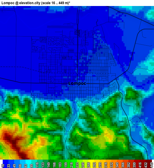
Below is the Elevation map of Lompoc, which displays elevation range with different colors. Scale of the first map is from 16 to 449 m (52 to 1473 ft) with average elevation of 90.7 meters (=298 ft) [note 1]
These maps also provides idea of topography and contour of this city, they are displayed at different zoom levels. More info about maps, scale and edge coordinates you can find below images.
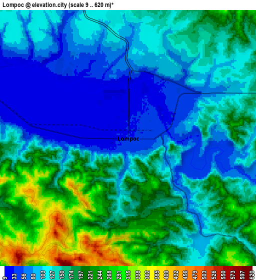
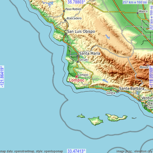
| \ | Map #1 | Map #2 | Topo.Map |
| Scale [m] | 16..449 m | 9..620 m | × |
| Scale [ft] | 52..1473 ft | 30..2034 ft | × |
| Average | 90.7 m = 298 ft | 147.1 m = 483 ft | × |
| Width | 8.04 km = 5 mi | 16.08 km = 10 mi | 257.3 km = 159.9 mi |
| Height | 8.04 km = 5 mi | 16.08 km = 10 mi | 257.3 km = 159.9 mi |
| ↑Max Latitude | 34.675298° | 34.71143° | 35.78803° |
| Latitude at center | 34.63915° | 34.63915° | 34.63915° |
| ↓Min Latitude | 34.602986° | 34.566807° | 33.47413° |
| ← Min Longitude | -120.501885° | -120.545831° | -121.86419° |
| Longitude center | -120.45794° | -120.45794° | -120.45794° |
| →Max Longitude | -120.413995° | -120.370049° | -119.05169° |
Nearby cities:
Cities around Lompoc sort by population:
• Santa Maria elevation 68 m
35 km,  3°
3°
• Orcutt 113 m
25.2 km, 4°
• Nipomo 102 m
44.9 km,  357°
357°
• Guadalupe 27 m
38.4 km,  344°
344°
• Vandenberg Village 116 m
7.7 km,  353°
353°
• Solvang 152 m
29.7 km,  99°
99°
• Buellton 113 m
24.4 km, 96°
• Santa Ynez 187 m
34.7 km,  94°
94°
• Mission Hills 102 m
5.6 km,  20°
20°
• Vandenberg Air Force Base 168 m
13.3 km, 335°
• Los Alamos 178 m
20.2 km,  54°
54°
• Los Olivos 255 m
31.5 km,  84°
84°
Multilingual:
 En español:
Lompoc elevación 34 m.
 En France:
Lompoc élévation 34 m.


Sources and notes:
- [note 1] Map square and city borders are not equal. Map elevation data is calculated only from area inside that square.
- [src 1] Elevation data from geonames database provided with same terms of usage.
- [src 2] The elevation map of Lompoc is generated using elevation data from NASA's 3 arcsec (90m) resolution SRTM data.
- [src 3] Base (background) map © OpenStreetMap contributors tiles are generated by Geofabrik and OpenTopoMap.
Copyright & License:
This Lompoc Elevation Map is licensed under CC BY-SA. You may reuse any part from this page, if you give a proper credit by linking to this URL:
 More info on terms of use page.