Lockeford elevation
Lockeford (California, San Joaquin County), United States elevation is 34 meters and Lockeford elevation in feet is 112 ft above sea level [src 1]. Lockeford is a populated place (feature code) with elevation that is 245 meters (804 ft) smaller than average city elevation in United States.
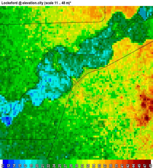
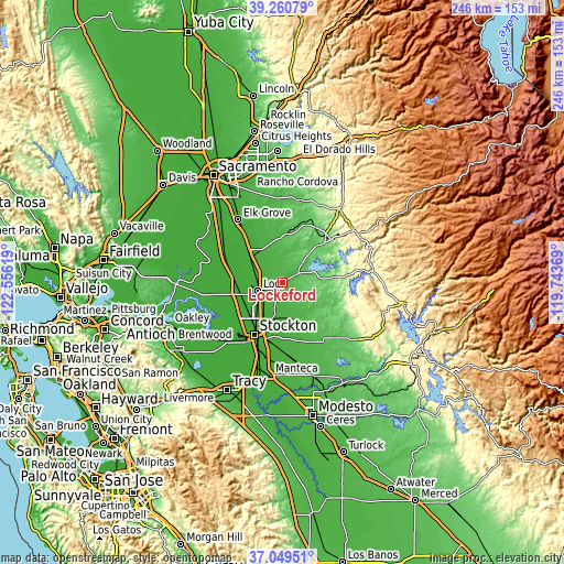
Below is the Elevation map of Lockeford, which displays elevation range with different colors. Scale of the first map is from 11 to 48 m (36 to 157 ft) with average elevation of 27.7 meters (=91 ft) [note 1]
These maps also provides idea of topography and contour of this city, they are displayed at different zoom levels. More info about maps, scale and edge coordinates you can find below images.
| \ | Map #1 | Topo.Map |
| Scale [m] | 11..48 m | × |
| Scale [ft] | 36..157 ft | × |
| Average | 27.7 m = 91 ft | × |
| Width | 7.68 km = 4.8 mi | 245.9 km = 152.8 mi |
| Height | 7.68 km = 4.8 mi | 245.9 km = 152.8 mi |
| ↑Max Latitude | 38.198074° | 39.26079° |
| Latitude at center | 38.16353° | 38.16353° |
| ↓Min Latitude | 38.12897° | 37.04951° |
| ← Min Longitude | -121.193885° | -122.55619° |
| Longitude center | -121.14994° | -121.14994° |
| →Max Longitude | -121.105995° | -119.74369° |
Nearby cities:
Cities around Lockeford sort by population:
• Lodi elevation 15 m
11.3 km,  250°
250°
• Galt 14 m
16.6 km,  307°
307°
• Garden Acres 10 m
23.3 km,  197°
197°
• August 9 m
22.8 km,  205°
205°
• Lincoln Village 6 m
23.5 km,  221°
221°
• Woodbridge 16 m
13.3 km,  265°
265°
• Morada 16 m
16.2 km, 211°
• Dogtown 46 m
7.7 km,  43°
43°
• Collierville 19 m
11.8 km,  298°
298°
• Linden 29 m
16.8 km,  159°
159°
• Clay 32 m
19.2 km,  357°
357°
• Herald 22 m
16.9 km,  330°
330°
Multilingual:
 En español:
Lockeford elevación 34 m.
 En France:
Lockeford élévation 34 m.
 Auf Deutsch:
Lockeford höhe über dem Meeresspiegel ist 34 m.

Sources and notes:
- [note 1] Map square and city borders are not equal. Map elevation data is calculated only from area inside that square.
- [src 1] Elevation data from geonames database provided with same terms of usage.
- [src 2] The elevation map of Lockeford is generated using elevation data from NASA's 3 arcsec (90m) resolution SRTM data.
- [src 3] Base (background) map © OpenStreetMap contributors tiles are generated by Geofabrik and OpenTopoMap.
Copyright & License:
This Lockeford Elevation Map is licensed under CC BY-SA. You may reuse any part from this page, if you give a proper credit by linking to this URL:
 More info on terms of use page.