La Cañada Flintridge elevation
La Cañada Flintridge (California, Los Angeles County), United States elevation is 365 meters and La Cañada Flintridge elevation in feet is 1198 ft above sea level [src 1]. La Cañada Flintridge is a populated place (feature code) with elevation that is 86 meters (282 ft) bigger than average city elevation in United States.
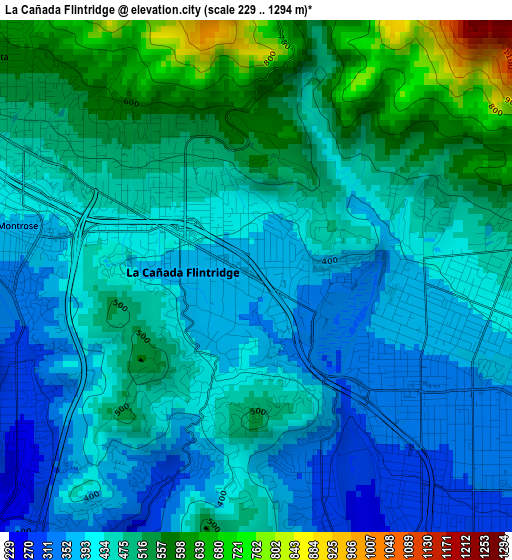
Below is the Elevation map of La Cañada Flintridge, which displays elevation range with different colors. Scale of the first map is from 229 to 1294 m (751 to 4245 ft) with average elevation of 456.5 meters (=1498 ft) [note 1]
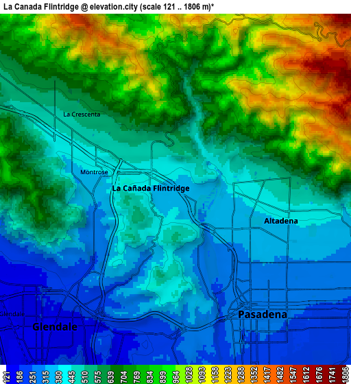
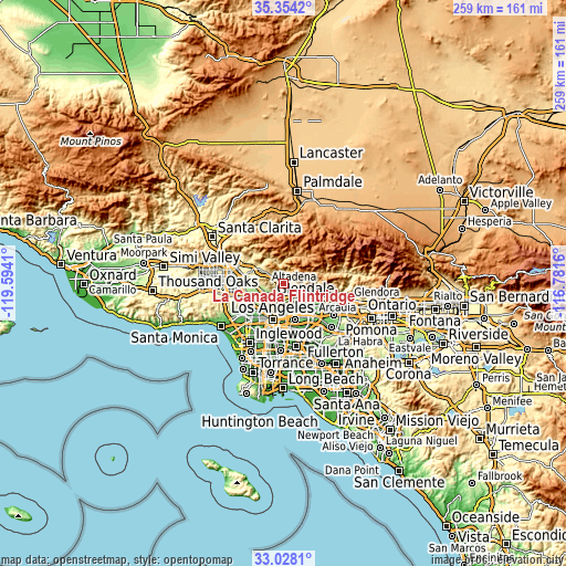
These maps also provides idea of topography and contour of this city, they are displayed at different zoom levels. More info about maps, scale and edge coordinates you can find below images.
| \ | Map #1 | Map #2 | Topo.Map |
| Scale [m] | 229..1294 m | 121..1806 m | × |
| Scale [ft] | 751..4245 ft | 397..5925 ft | × |
| Average | 456.5 m = 1498 ft | 570.3 m = 1871 ft | × |
| Width | 8.08 km = 5 mi | 16.17 km = 10 mi | 258.6 km = 160.7 mi |
| Height | 8.08 km = 5 mi | 16.17 km = 10 mi | 258.6 km = 160.7 mi |
| ↑Max Latitude | 34.235509° | 34.271832° | 35.3542° |
| Latitude at center | 34.19917° | 34.19917° | 34.19917° |
| ↓Min Latitude | 34.162815° | 34.126445° | 33.0281° |
| ← Min Longitude | -118.231795° | -118.275741° | -119.5941° |
| Longitude center | -118.18785° | -118.18785° | -118.18785° |
| →Max Longitude | -118.143905° | -118.099959° | -116.7816° |
Nearby cities:
Cities around La Cañada Flintridge sort by population:
• Glendale elevation 161 m
8.8 km,  224°
224°
• Pasadena 272 m
7 km,  145°
145°
• Burbank 192 m
11.3 km,  259°
259°
• Alhambra 153 m
12.8 km, 154°
• Altadena 420 m
5.3 km,  101°
101°
• Tujunga 546 m
11 km,  302°
302°
• South Pasadena 202 m
9.9 km,  159°
159°
• La Crescenta-Montrose 565 m
5.7 km,  310°
310°
• Sunland 464 m
12.9 km, 305°
• San Marino 177 m
11.4 km,  139°
139°
• Sierra Madre 255 m
13.1 km,  108°
108°
• East Pasadena 193 m
12.5 km,  122°
122°
Multilingual:
 En español:
La Cañada Flintridge elevación 365 m.
 En France:
La Cañada Flintridge élévation 365 m.
 Auf Deutsch:
La Cañada Flintridge höhe über dem Meeresspiegel ist 365 m.
 На русском:
Ла-Каньяда-Флинтридж высота над уровнем моря 365 м
Sources and notes:
- [note 1] Map square and city borders are not equal. Map elevation data is calculated only from area inside that square.
- [src 1] Elevation data from geonames database provided with same terms of usage.
- [src 2] The elevation map of La Cañada Flintridge is generated using elevation data from NASA's 3 arcsec (90m) resolution SRTM data.
- [src 3] Base (background) map © OpenStreetMap contributors tiles are generated by Geofabrik and OpenTopoMap.
Copyright & License:
This La Cañada Flintridge Elevation Map is licensed under CC BY-SA. You may reuse any part from this page, if you give a proper credit by linking to this URL:
 More info on terms of use page.